Ben of Howth
Hilly area on Howth Head near Dublin, Ireland
The Ben of Howth (/ˈhoʊθ/ HOHTH; Irish: Beann Éadair ) is a hilly area[2] on Howth Head, adjacent to the 171 metre high Black Linn,[2] the peninsula's highest point.[2]
| Ben of Howth | |
|---|---|
| Beann Éadair | |
 Ben of Howth Radio Mast | |
| Highest point | |
| Elevation | 171 m (561 ft)[1] |
| Prominence | 167 m (548 ft)[1] |
| Listing | Marilyn |
| Geography | |
Lua error in Module:Location_map at line 425: No value was provided for longitude.
| |
| Location | Dublin, Ireland |
| OSI/OSNI grid | O285376 |
| Topo map | OSi Discovery 50 |
Geography
Lying approximately 1½ km to the south of Howth village, the nearest road is Windgate Road, from which a path leads west past Green Hollows quarry.
Two of Howth's other peaks are nearby, Shelmartin or Shielmartin[2] which lies approximately 1 km to the west, and Dun Hill,[2] 0.5 km to the north west.
Gallery
-
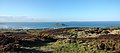 North-facing view
 -
 Northwest facing view
 -
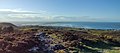
 Ben of Howth, southwest facing view
 -
 Ben of Howth, east view


References and notes
- ^ 1.0 1.1 "East Coast Area - Ben of Howth". MountainViews. Ordnance Survey Ireland. Retrieved 5 July 2015.
- ^ 2.0 2.1 2.2 2.3 2.4 The Neighbourhood of Dublin - Chapter 32[usurped], Weston St John Joyce, Dublin, MH Gill and Son, 1912, - multiple mentions