
File:Antarctic bottom water.svg

Original file (SVG file, nominally 745 × 470 pixels, file size: 42 KB)
| This is a file from the Wikimedia Commons. Information from its description page there is shown below. Commons is a freely licensed media file repository. You can help. |
Summary
| Description |
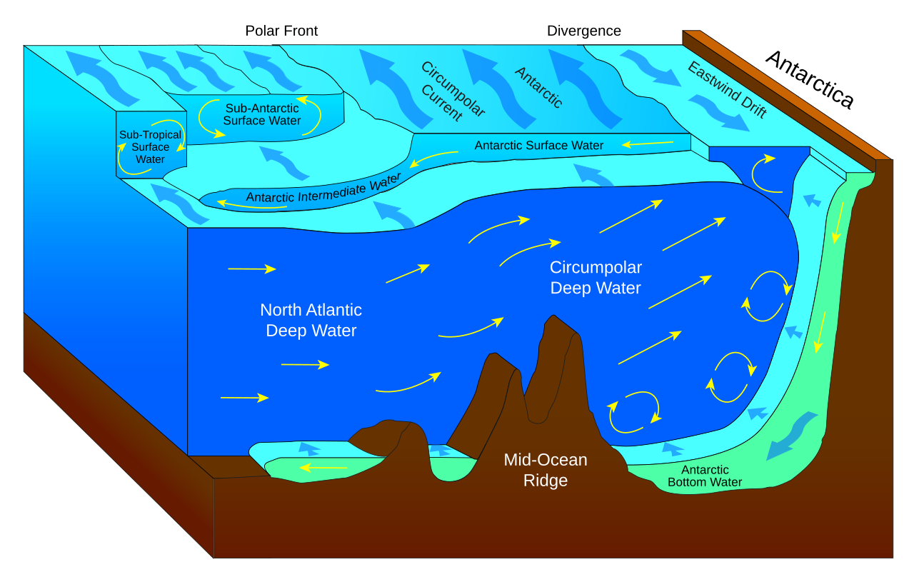
English: Water mass bodies of the Southern Ocean.
Català: Cossos de massa d'aigua de l'oceà austral. |
| Date | |
| Source |
 |
| Author | Fred the Oyster |
| Other versions |
File:Antarctic bottom water.svg has 2 translations.
|


| This SVG file contains embedded text that can be translated into your language, using any capable SVG editor, text editor or the SVG Translate tool. For more information see: About translating SVG files. |
This file is translated using SVG <switch> elements. All translations are stored in the same file! Learn more.
For most Wikipedia projects, you can embed the file normally (without a To translate the text into your language, you can use the SVG Translate tool. Alternatively, you can download the file to your computer, add your translations using whatever software you're familiar with, and re-upload it with the same name. You will find help in Graphics Lab if you're not sure how to do this. |
Licensing
- You are free:
- to share – to copy, distribute and transmit the work
- to remix – to adapt the work
- Under the following conditions:
- attribution – You must give appropriate credit, provide a link to the license, and indicate if changes were made. You may do so in any reasonable manner, but not in any way that suggests the licensor endorses you or your use.
- share alike – If you remix, transform, or build upon the material, you must distribute your contributions under the same or compatible license as the original.
File history
Click on a date/time to view the file as it appeared at that time.
| Date/Time | Thumbnail | Dimensions | User | Comment | |
|---|---|---|---|---|---|
| current | 01:50, 17 March 2022 | | 745 × 470 (42 KB) | wikimediacommons>Manlleus | File uploaded using svgtranslate tool (https://svgtranslate.toolforge.org/). Added translation for ca. |
File usage
More than 100 pages use this file. The following list shows the first 100 pages that use this file only. A full list is available.
- Airy wave theory
- Antarctic bottom water
- Atlantic meridional overturning circulation
- Atoll
- Azores Current
- Bahama Banks
- Baroclinity
- CORA dataset
- Cnoidal wave
- Coastal geography
- Color of water
- Continental margin
- Coriolis (project)
- Coriolis force
- Craik–Leibovich vortex force
- DSV Alvin
- Deep ocean water
- Deep scattering layer
- Divergent boundary
- Downwelling
- Echo sounding
- Edge wave
- Ekman transport
- Enderby Plain
- Faroe-Bank Channel overflow
- General circulation model
- Geochemical Ocean Sections Study
- Geophysical fluid dynamics
- Global Ocean Data Analysis Project
- Gravity wave
- Gulf Stream
- Guyot
- Head of tide
- High-nutrient, low-chlorophyll regions
- Hydrography
- Infragravity wave
- Iribarren number
- Kinematic wave
- Knoll (oceanography)
- Lofoten Vortex
- Luke's variational principle
- Marine biogeochemical cycles
- Marine energy
- Marine pollution
- Megatsunami
- Meteotsunami
- Mild-slope equation
- Modulational instability
- North Atlantic Deep Water
- North West Shelf Operational Oceanographic System
- OSTM/Jason-2
- Ocean
- Ocean exploration
- Ocean observations
- Ocean stratification
- Ocean surface topography
- Ocean thermal energy conversion
- Oceanic plateau
- Oceanic trench
- Oceanography
- Outer trench swell
- Overflow (oceanography)
- Paleotsunami
- Photic zone
- Porcupine Seabight
- RAFOS float
- Radiation stress
- Rule of twelfths
- SOCCOM project
- Sea
- Sea-level curve
- SeaDataNet
- Sea level
- Sea surface microlayer
- Seafloor spreading
- Seamount
- Shallow water equations
- Slab suction
- Sofar bomb
- Soliton
- Stokes drift
- Stokes problem
- Stokes wave
- Subduction
- Submarine volcano
- Subsurface ocean current
- Tidal force
- Tide
- Transform fault
- Trochoidal wave
- Tsunami
- Undersea mountain range
- Upwelling
- Ursell number
- Wave height
- Wave setup
- Wave shoaling
- Wave–current interaction
- Wind setup
- World Geodetic System
View more links to this file.