
File:Cayman Islands Map.svg

Size of this PNG preview of this SVG file: 502 × 249 pixels. Other resolutions: 320 × 159 pixels | 640 × 317 pixels | 1,024 × 508 pixels | 1,280 × 635 pixels | 2,560 × 1,270 pixels.
Original file (SVG file, nominally 502 × 249 pixels, file size: 18 KB)
| This is a file from the Wikimedia Commons. Information from its description page there is shown below. Commons is a freely licensed media file repository. You can help. |
Summary
| Description |
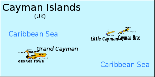
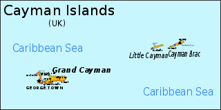
English: Map of the Cayman Islands. Information from CIA MAP, Yahoo Map, [1] Can be translated through version 1 here, although text must be converted to path due to rendering problems. |
| Date | original unknown |
| Source | outline from PlaniGlobe |
| Author | Planiglobe (outline), RaviC |
| Other versions |
Derivative works of this file: |
| SVG development |
![[1]](http://www.wordtravels.com/images/map/Cayman_Islands_map.jpg)
Licensing
This file is licensed under the Creative Commons Attribution 2.5 Generic license.
- You are free:
- to share – to copy, distribute and transmit the work
- to remix – to adapt the work
- Under the following conditions:
- attribution – You must give appropriate credit, provide a link to the license, and indicate if changes were made. You may do so in any reasonable manner, but not in any way that suggests the licensor endorses you or your use.
File history
Click on a date/time to view the file as it appeared at that time.
| Date/Time | Thumbnail | Dimensions | User | Comment | |
|---|---|---|---|---|---|
| current | 10:56, 16 June 2024 | | 502 × 249 (18 KB) | wikimediacommons>ToprakM | File uploaded using svgtranslate tool (https://svgtranslate.toolforge.org/). Added translation for tr. |
File usage
The following 6 pages use this file: