File:Conceptions Colomb map-en.svg

Original file (SVG file, nominally 1,022 × 635 pixels, file size: 857 KB)
| This is a file from the Wikimedia Commons. Information from its description page there is shown below. Commons is a freely licensed media file repository. You can help. |
Summary
| Description |
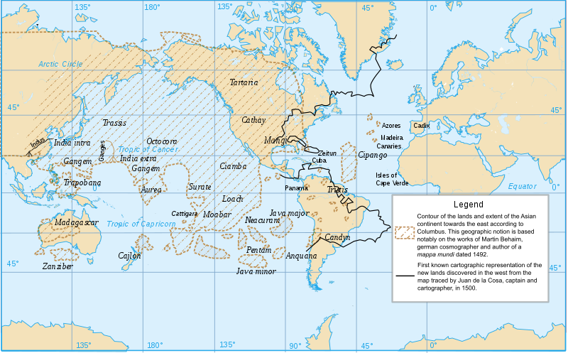
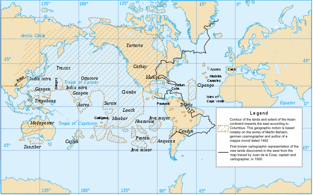
English: Columbus’s geographical conceptions |
| Date | |
| Source | Own work |
| Author | Mindriot |
| Other versions | Conceptions Colomb map-fr.svg |
| SVG development |
Translated from Conceptions Colomb map-fr.svg which was created by Ewan_ar_Born.
Based upon a map published in Jean Amsler, « La Renaissance (1415-1600) », Histoire universelle des explorations, tome II, Nouvelle Librairie de France, 1968, p. 56/57 (encart couleur).
Legend
[1: brown shades] Contour of the lands and extent of the Asian continent towards the east according to Columbus. This geograpic notion is based notably on the works of Martin Behaim, german cosmographer and author of a mappa mundi dated 1492.
[2: black line] First known cartographic representation of the new lands discovered in the west from the map traced by Juan de la Cosa, captain and cartographer, in 1500.
Licensing
- You are free:
- to share – to copy, distribute and transmit the work
- to remix – to adapt the work
- Under the following conditions:
- attribution – You must give appropriate credit, provide a link to the license, and indicate if changes were made. You may do so in any reasonable manner, but not in any way that suggests the licensor endorses you or your use.
- share alike – If you remix, transform, or build upon the material, you must distribute your contributions under the same or compatible license as the original.
File history
Click on a date/time to view the file as it appeared at that time.
| Date/Time | Thumbnail | Dimensions | User | Comment | |
|---|---|---|---|---|---|
| current | 18:09, 28 December 2013 | | 1,022 × 635 (857 KB) | wikimediacommons>Mindriot | User created page with UploadWizard |
File usage
The following 2 pages use this file: