
File:CrossrailLine1Map.svg

Size of this PNG preview of this SVG file: 800 × 204 pixels. Other resolutions: 320 × 82 pixels | 640 × 163 pixels | 1,024 × 261 pixels | 1,280 × 327 pixels | 2,560 × 653 pixels | 1,960 × 500 pixels.
Original file (SVG file, nominally 1,960 × 500 pixels, file size: 28 KB)
| This is a file from the Wikimedia Commons. Information from its description page there is shown below. Commons is a freely licensed media file repository. You can help. |
| Description |
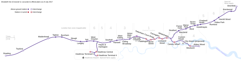
Deutsch: Übersicht über das London-Crossrail-Projekt English: A map of the proposed Crossrail system in London. Geographical data references OpenStreetMap. Français : Un plan du chemin de fer proposé Crossrail à Londres. |
| Source | Crossrail official site |
| Author | David Arthur |
| Permission (Reusing this file) |
This file is licensed under the Creative Commons Attribution-Share Alike 2.0 Canada license.
 |
| Other versions |
Derivative works of this file: |
W3C-validity not checked.
File history
Click on a date/time to view the file as it appeared at that time.
| Date/Time | Thumbnail | Dimensions | User | Comment | |
|---|---|---|---|---|---|
| current | 21:56, 17 February 2020 | 1,960 × 500 (28 KB) | wikimediacommons>RaviC | OOC confirmed for 2026 |
File usage
The following 2 pages use this file: