
File:Hydroprogne caspia map.svg

Size of this PNG preview of this SVG file: 800 × 413 pixels. Other resolutions: 320 × 165 pixels | 640 × 330 pixels | 1,024 × 529 pixels | 1,280 × 661 pixels | 2,560 × 1,321 pixels | 3,100 × 1,600 pixels.
Original file (SVG file, nominally 3,100 × 1,600 pixels, file size: 1.58 MB)
| This is a file from the Wikimedia Commons. Information from its description page there is shown below. Commons is a freely licensed media file repository. You can help. |
Summary
| Description |
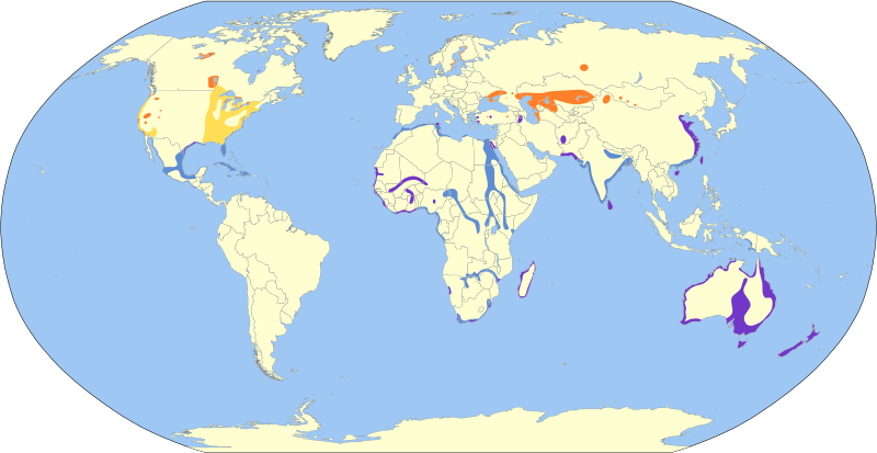
Français : Carte de répartition de la Sterne caspienne.
Aire de nidification Voie migratoire Présent à l'année Aire d'hivernage English: Geographical distribution of Caspian tern. Breeding Migration Year-round Nonbreeding |
| Date | |
| Source | BirdLife International. 2017. Hydroprogne caspia (amended version of 2016 assessment). The IUCN Red List of Threatened Species 2017: e.T22694524A111757252. https://dx.doi.org/10.2305/IUCN.UK.2017-1.RLTS.T22694524A111757252.en. Downloaded on 03 June 2018. |
| Author | Cephas |
Licensing
I, the copyright holder of this work, hereby publish it under the following license:
This file is licensed under the Creative Commons Attribution-Share Alike 4.0 International license.
- You are free:
- to share – to copy, distribute and transmit the work
- to remix – to adapt the work
- Under the following conditions:
- attribution – You must give appropriate credit, provide a link to the license, and indicate if changes were made. You may do so in any reasonable manner, but not in any way that suggests the licensor endorses you or your use.
- share alike – If you remix, transform, or build upon the material, you must distribute your contributions under the same or compatible license as the original.
File history
Click on a date/time to view the file as it appeared at that time.
| Date/Time | Thumbnail | Dimensions | User | Comment | |
|---|---|---|---|---|---|
| current | 18:26, 3 June 2018 | | 3,100 × 1,600 (1.58 MB) | wikimediacommons>Cephas | User created page with UploadWizard |
File usage
The following page uses this file: