
File:Jian'an Commanderies.svg

Size of this PNG preview of this SVG file: 800 × 576 pixels. Other resolutions: 320 × 230 pixels | 640 × 461 pixels | 1,024 × 737 pixels | 1,280 × 922 pixels | 2,560 × 1,843 pixels | 3,125 × 2,250 pixels.
Original file (SVG file, nominally 3,125 × 2,250 pixels, file size: 7.37 MB)
| This is a file from the Wikimedia Commons. Information from its description page there is shown below. Commons is a freely licensed media file repository. You can help. |
Summary
| Description |
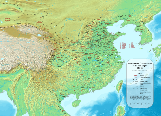
English: Provinces and commanderies of the Han Dynasty in 219 CE, during the Jian'an era
中文(中国大陆):东汉建安时期州郡地图(建安二十四年,公元219年) |
| Date | |
| Source |
Own work using:
|
| Author | Esiymbro |
Licensing
I, the copyright holder of this work, hereby publish it under the following license:
This file is licensed under the Creative Commons Attribution-Share Alike 4.0 International license.
- You are free:
- to share – to copy, distribute and transmit the work
- to remix – to adapt the work
- Under the following conditions:
- attribution – You must give appropriate credit, provide a link to the license, and indicate if changes were made. You may do so in any reasonable manner, but not in any way that suggests the licensor endorses you or your use.
- share alike – If you remix, transform, or build upon the material, you must distribute your contributions under the same or compatible license as the original.
File history
Click on a date/time to view the file as it appeared at that time.
| Date/Time | Thumbnail | Dimensions | User | Comment | |
|---|---|---|---|---|---|
| current | 02:50, 20 May 2022 | | 3,125 × 2,250 (7.37 MB) | wikimediacommons>Esiymbro | Corrections and more details |
File usage
The following 34 pages use this file:
- Anding Commandery
- Beidi Commandery
- Bohai Commandery
- Chen Commandery
- Fufeng (region)
- Government of the Han dynasty
- Guangyang Commandery
- Han dynasty
- Hedong Commandery
- Henan Commandery
- Henei Commandery
- Hongnong Commandery
- Jingzhao
- Jiyin Commandery
- Kuaiji Commandery
- Lelang Commandery
- Liang Province
- Liaodong Commandery
- Liaoxi Commandery
- List of provinces and commanderies of the Han dynasty
- Lu Commandery
- Military history of the Three Kingdoms
- Pei Commandery
- Pingyi (region)
- Shanggu Commandery
- Sili Province
- Wuyuan Commandery
- Yingchuan Commandery
- Yizhou (Southwest China)
- Youbeiping Commandery
- Yunzhong Commandery
- Yuyang Commandery
- Zhuo Commandery
- Template:Han dynasty provinces