
File:Kangshung-06.PNG

Size of this preview: 800 × 526 pixels. Other resolutions: 320 × 210 pixels | 640 × 421 pixels | 1,157 × 761 pixels.
Original file (1,157 × 761 pixels, file size: 1.95 MB, MIME type: image/png)
| This is a file from the Wikimedia Commons. Information from its description page there is shown below. Commons is a freely licensed media file repository. You can help. |
Summary
| Description |
Deutsch: Ost- (Kangshung-) Wand des Mount Everest mit Umgebung |
|
| Date | 12 November 2008 (original upload date) | |
| Source | Transferred from de.wikipedia to Commons by Rupert Pupkin using CommonsHelper. | |
| Author |
Photograph: NASA |
|
| Other versions |
|


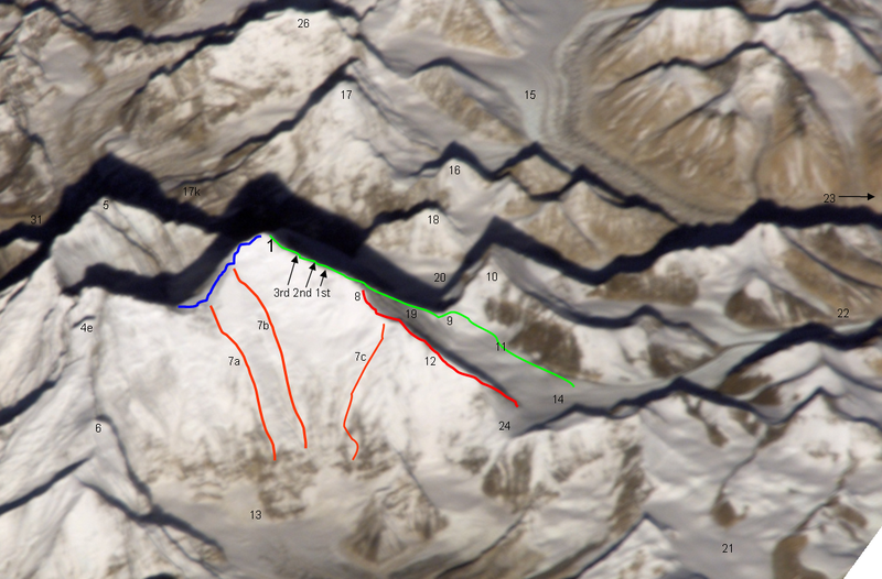
Notes
| green line | Normal route, mainly the Mallory route 1924, via high camps on 7700 and 8300 m, via "yellow band", exit cracks & upper NE ridge w. "Second Step") |
| red line / no.12 | lower and middle NE ridge |
| blue line | upper SE ridge (part of the «Hillary route» 1953 etc. coming from Western Qwm (in the shadow behind Mt. Everest) meeting point with the orange route 7a is the south col meeting point with the orange route 7b is the balcony |
| orange line 7a | 1988 US and GB ascent (Stephen Vernables et al.) |
| orange line 7b | 1982 US ascent (Carlos Buhler, Kim Momb et al.) |
| orange line 7c | “Phantasy Ridge” (acc. to a speech of George Mallory), no successful ascent until 2008, tried by Cathy O’Dowd and Ian Woodall; they came half way to NE ridge & Pinnacles |
| 1 | summit of Mount Everest 8848m |
| 3rd 2nd 1st | steps on the Upper NE ridge 8700m, 8605m and 8530m |
| 4e | Lhotse Shar |
| 5 | Nuptse |
| 6 | “Peak 38” |
| 13 | Kangshung Glacier |
| 8 | “Three Pinnacles” where Joe Tasker and Peter Boardman died 1982 (2nd pinnacle) |
| 9 | North Col on 7050m |
| 14 | East Rongbuk Glacier |
| 10 | Changtse (northern summit) |
| 11 | ABC Advanced Base Camp (North) on the upper East Rongbuk Glacier in front of the ice wall to north col |
| 15 | West Rongbuk Glacier (coming from the Cho Oyu and Gyachung Kang flanks) |
| 16 | Lingtren |
| 17 | Pumori |
| 17k | Kala Patthar, “Everest Trekking View Point” from the south side |
| 18 | Khumbutse (summit west of Lho La which is the connection on 6006m of the glacier systems of Rongbu and Khumbu and is also the tibetian-nepalian borderline / like SE ridge & W ridge. Lho La is "foot point" of the Everest W ridge.) |
| 19 | north ridge // below of fig. 19 the Zakharov Couloir offering a tough ascent to NE ridge without going via north col |
| 20 | Main Rongbuk Glacier |
| 21 | upper Kharta Glacier (Mallory 1921, where discovered the access to North Col) |
| 22 | Camp II of the early british expeditions 1922+1924 |
| 23 | to the Base camp on foot of the Main Rongbuk Glacier and to Rongbuk Gompa (Monastery) |
| 24 | Rapiu La (connection from Eastern Rongbuk Glacier System to Kangshung Glacier System) |
Licensing
Original photograph:
| This file is in the public domain in the United States because it was solely created by NASA. NASA copyright policy states that "NASA material is not protected by copyright unless noted". (See Template:PD-USGov, NASA copyright policy page or JPL Image Use Policy.) |
Lines and points:
Kassander der Minoer at German Wikipedia, the copyright holder of this work, hereby publishes it under the following license:

|
Permission is granted to copy, distribute and/or modify this document under the terms of the GNU Free Documentation License, Version 1.2 or any later version published by the Free Software Foundation; with no Invariant Sections, no Front-Cover Texts, and no Back-Cover Texts. A copy of the license is included in the section entitled GNU Free Documentation License. |
| This file is licensed under the Creative Commons Attribution-Share Alike 3.0 Unported license. | ||
Attribution:
| ||
| ||
| This licensing tag was added to this file as part of the GFDL licensing update. |
Original upload log
The original description page was here. All following user names refer to de.wikipedia.
- 2008-11-12 20:39 Kassander der Minoer 1157×761× (2046200 bytes) {{Information |Beschreibung = Ost- (Kangshung-) Wand des Mount Everest mit Umgebung |Quelle = NASA & eigene Arbeit (Linien und Punkte markiert) |Urheber = NASA |Datum = 12.11.2008 |Genehmigung = US-Gov-GFDL |Andere Versionen = |Anmerkungen = }}
File history
Click on a date/time to view the file as it appeared at that time.
| Date/Time | Thumbnail | Dimensions | User | Comment | |
|---|---|---|---|---|---|
| current | 22:59, 26 November 2008 | | 1,157 × 761 (1.95 MB) | wikimediacommons>File Upload Bot (Magnus Manske) | {{BotMoveToCommons|de.wikipedia}} {{Information |Description={{de|Ost- (Kangshung-) Wand des Mount Everest mit Umgebung}} |Source=Transferred from [http://de.wikipedia.org de.wikipedia]; transferred to Commons by User:Rupert Pupkin using [http://tool |
File usage
The following 2 pages use this file: