
File:Le Train Network Map.svg

Size of this PNG preview of this SVG file: 560 × 599 pixels. Other resolutions: 224 × 240 pixels | 449 × 480 pixels | 718 × 768 pixels | 957 × 1,024 pixels | 1,914 × 2,048 pixels.
Original file (SVG file, nominally 800 × 856 pixels, file size: 129 KB)
| This is a file from the Wikimedia Commons. Information from its description page there is shown below. Commons is a freely licensed media file repository. You can help. |
Summary
| Description |
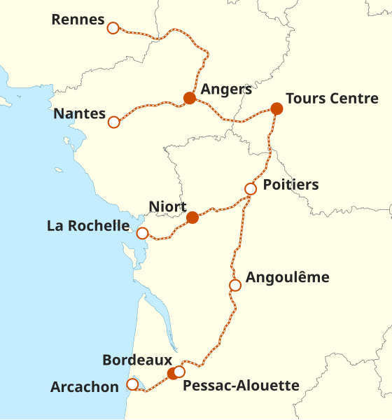
English: The proposed network map of upcoming French open-access high-speed rail operator Le Train |
| Date | |
| Source |
Own work based on: SNCF RÉSEAU (in fr). Carte du réseau ferré national. Retrieved on 21 June 2023. and this map
|
| Author | M.Bitton |
| SVG development | This vector image was created with a text editor. |
Licensing
I, the copyright holder of this work, hereby publish it under the following license:
This file is licensed under the Creative Commons Attribution-Share Alike 3.0 Unported license.
- You are free:
- to share – to copy, distribute and transmit the work
- to remix – to adapt the work
- Under the following conditions:
- attribution – You must give appropriate credit, provide a link to the license, and indicate if changes were made. You may do so in any reasonable manner, but not in any way that suggests the licensor endorses you or your use.
- share alike – If you remix, transform, or build upon the material, you must distribute your contributions under the same or compatible license as the original.
File history
Click on a date/time to view the file as it appeared at that time.
| Date/Time | Thumbnail | Dimensions | User | Comment | |
|---|---|---|---|---|---|
| current | 14:22, 9 May 2025 | | 800 × 856 (129 KB) | wikimediacommons>M.Bitton | Slight adjustment (in line with the newly released map) |
File usage
The following 3 pages use this file: