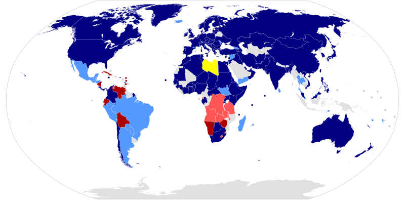
File:LibyanRepublicRelations.svg

Size of this PNG preview of this SVG file: 800 × 395 pixels. Other resolutions: 320 × 158 pixels | 640 × 316 pixels | 1,024 × 506 pixels | 1,280 × 633 pixels | 2,560 × 1,265 pixels | 880 × 435 pixels.
Original file (SVG file, nominally 880 × 435 pixels, file size: 1.3 MB)
| This is a file from the Wikimedia Commons. Information from its description page there is shown below. Commons is a freely licensed media file repository. You can help. |
Summary
| DescriptionLibyanRepublicRelations.svg |
Հայերեն: Աշխարհի ընդհանուր քարտեզ, որը ցույց է տալիս այն երկրները, որոնք ճանաչել կամ ոչ պաշտոնական հարաբերություններ են ունեցել Լիբիայի Հանրապետության հետ 2011թ. քաղաքացիական պատերազմի ընթացքում:
Español: Mapamundi de las relaciones diplomáticas que otros países mantuvieron con el Consejo Nacional de Transición de Libia durante la Guerra Civil de 2011.
Deutsch: Eine Weltkarte, die Staaten zeigt, welche den Nationalen Übergangsrat anerkennen oder informelle Beziehungen zu diesem haben.
English: A global map of the world showing countries that recognized or had informal relations with the Libyan Republic during the civil war of 2011.
Français : Une carte du monde représentant les pays ayant reconnu ou ayant des relations avec le w:Conseil National de Transition.
Македонски: Карта на државите во светот според воспоставените дипломатски односи со Либија.
Nederlands: Een wereldkaart die staten toont die de Nationale Overgangsraad erkennen of er informele betrekkingen mee onderhouden.
Português: Mapa-mundi mostrando as relações internacionais do w:Conselho Nacional de Transição da w:Líbia
Română: O hartă a lumii reprezentând țările ce au recunoscut Consiliul Național de Tranziție ca reprezentantul legitim al poporului libian.
Русский: Карта мира со странами, которые признают или имеют неформальные отношения с НПС Ливии.
Türkçe: Libya Cumhuriyeti ile resmi veya gayri resmi ilişkileri olan ülkelerin dünya haritası.
中文:地图示意正式或非正式承认利比亚全国过渡委员会的国家或地区.
日本語: リビア国民評議会に対する各国の認識を示した世界地図。
|
| Source |
File:BlankMap-World-Microstates.svg This W3C-unspecified vector image was created with Inkscape . |
| Author | Various (see below) |
Licensing
| Public domainPublic domainfalsefalse |
| I, the copyright holder of this work, release this work into the public domain. This applies worldwide. In some countries this may not be legally possible; if so: I grant anyone the right to use this work for any purpose, without any conditions, unless such conditions are required by law. |
Original upload log
The original description page was here. All following user names refer to en.wikipedia.
Upload date | User | Bytes | Dimensions | Comment
- 2011-08-16 00:49:44 | Haha169 | 1458104 | 880×435 | Don't know how China got left out. Simply following the table in the article, its got the same designation as Egypt, Greece, etc.,
- 2011-08-14 16:30:31 | U5K0 | 1458046 | 880×435 | sorry. my bad
- 2011-08-14 16:15:33 | U5K0 | 1462776 | 880×435 | Gabon as per countries table in the article
- 2011-08-12 23:53:26 | U5K0 | 1459143 | 880×435 | Botswana as per article and reference in article - see table with countries
- 2011-08-11 14:05:16 | Brightgalrs | 1457980 | 880×435 | Tweaked Sudan-South Sudan border (made it more visible)
- 2011-08-06 21:58:48 | Brightgalrs | 1457922 | 880×435 | Switched Kosovo and Montenegro's color. (Thanks Yalens)
- 2011-08-04 23:46:07 | Brightgalrs | 1457784 | 880×435 | Czech republic light blue Kosovo added back in (why did I delete this again?) as dark blue dot
- 2011-07-29 23:15:03 | U5K0 | 1456236 | 880×435 | portugal to dark blue as per talk page article
- 2011-07-21 16:03:28 | Brightgalrs | 1457158 | 880×435 | Montenegro
- 2011-07-20 18:18:56 | Brightgalrs | 1457086 | 880×435 | Added a grey dot for the Republic of Kosovo.
- 2011-07-20 17:34:23 | U5K0 | 1456212 | 880×435 | Slovenia recognises NTC as per http://www.mzz.gov.si/nc/si/splosno/cns/novica/article/6/29268/47f4795180/
- 2011-07-18 13:38:54 | Brightgalrs | 1455857 | 880×435 | Albania recognizes the NTC http://www.ora-news.com/v2/index.php?on=details&id=22692&nid=1&PHPSESSID=5d613e9758ecb4b261a2ea894f935fc4
- 2011-07-17 04:50:09 | Brightgalrs | 1455841 | 880×435 | South Sudan, resized
- 2011-07-17 04:05:44 | Brightgalrs | 1452050 | 940×477 | And I forgot Malta.
- 2011-07-17 04:03:51 | Brightgalrs | 1451955 | 940×477 | Added various dependencies of the USA, UK, Netherlands and France.
- 2011-07-16 18:53:29 | Brightgalrs | 1444235 | 940×477 | Forgot Senegal, good catch.
- 2011-07-16 02:24:34 | Brightgalrs | 1444231 | 940×477 | {{Information |Description = {{en|1=A global map of the world showing countries that recognize or have informal relations with the [[Libyan Republic]]}} |Source = [[:File:BlankMap-World-Microstates.svg]]<br>{{Inkscape}} |Date = ~~~
Captions
Add a one-line explanation of what this file represents
Items portrayed in this file
depicts
File history
Click on a date/time to view the file as it appeared at that time.
| Date/Time | Thumbnail | Dimensions | User | Comment | |
|---|---|---|---|---|---|
| current | 20:31, 7 December 2011 |  | 880 × 435 (1.3 MB) | wikimediacommons>Raistuumum | Mauritania and Eritrea to dark blue |
File usage
The following 4 pages use this file: