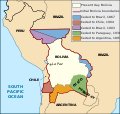
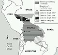
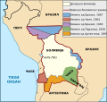
File:Map Bolivia territorial loss-en.svg

Size of this PNG preview of this SVG file: 375 × 355 pixels. Other resolutions: 254 × 240 pixels | 507 × 480 pixels | 811 × 768 pixels | 1,082 × 1,024 pixels | 2,163 × 2,048 pixels.
Original file (SVG file, nominally 375 × 355 pixels, file size: 78 KB)
File history
Click on a date/time to view the file as it appeared at that time.
| Date/Time | Thumbnail | Dimensions | User | Comment | |
|---|---|---|---|---|---|
| current | 17:19, 1 January 2020 |  | 375 × 355 (78 KB) | wikimediacommons>Janitoalevic | Added territory ceded to Argentina |
File usage
The following 5 pages use this file:


