
File:Map Denmark Demis SE islands.gif
No higher resolution available.
Map_Denmark_Demis_SE_islands.gif (415 × 420 pixels, file size: 23 KB, MIME type: image/gif)
| This is a file from the Wikimedia Commons. Information from its description page there is shown below. Commons is a freely licensed media file repository. You can help. |
Summary
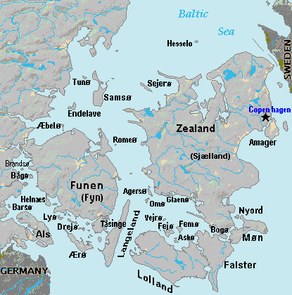
| Description | Terrain map of southeast Denmark, showing the major islands labeled, in the region between Germany and Sweden. The terrain data was extracted from the Demis map (on Wikimedia Commons) Image:La2-demis-denmark.png, and the extracted map was color-shifted to grayshade land areas (from the green Demis map). Labels are in font face Arial or Arial Narrow, sizes 8-10. |
| Date | |
| Source | Derivative of Demis map: Image:La2-demis-denmark.png |
| Author | Wikid77 (derivative of Demis map) |
Licensing
This image is in the public domain because it came from the site https://www.demis.nl/products/web-map-server/examples/ and was released by the copyright holder. Permission is granted to copy, distribute and/or modify this map since it is based on free of copyright images from: www.demis.nl. See also approval email on de.wp and its clarification.
|
| This work has been released into the public domain by its copyright holder, www.demis.nl. This applies worldwide. In some countries this may not be legally possible; if so: www.demis.nl grants anyone the right to use this work for any purpose, without any conditions, unless such conditions are required by law.
|
File history
Click on a date/time to view the file as it appeared at that time.
| Date/Time | Thumbnail | Dimensions | User | Comment | |
|---|---|---|---|---|---|
| current | 19:51, 3 September 2007 | | 415 × 420 (23 KB) | wikimediacommons>Wikid77 | added 14 island names |