File:Map of Ancient Rome 271 AD.svg

Size of this PNG preview of this SVG file: 800 × 473 pixels. Other resolutions: 320 × 189 pixels | 640 × 379 pixels | 1,024 × 606 pixels | 1,280 × 757 pixels | 2,560 × 1,515 pixels | 2,050 × 1,213 pixels.
Original file (SVG file, nominally 2,050 × 1,213 pixels, file size: 207 KB)
| This is a file from the Wikimedia Commons. Information from its description page there is shown below. Commons is a freely licensed media file repository. You can help. |
Summary
| Description |
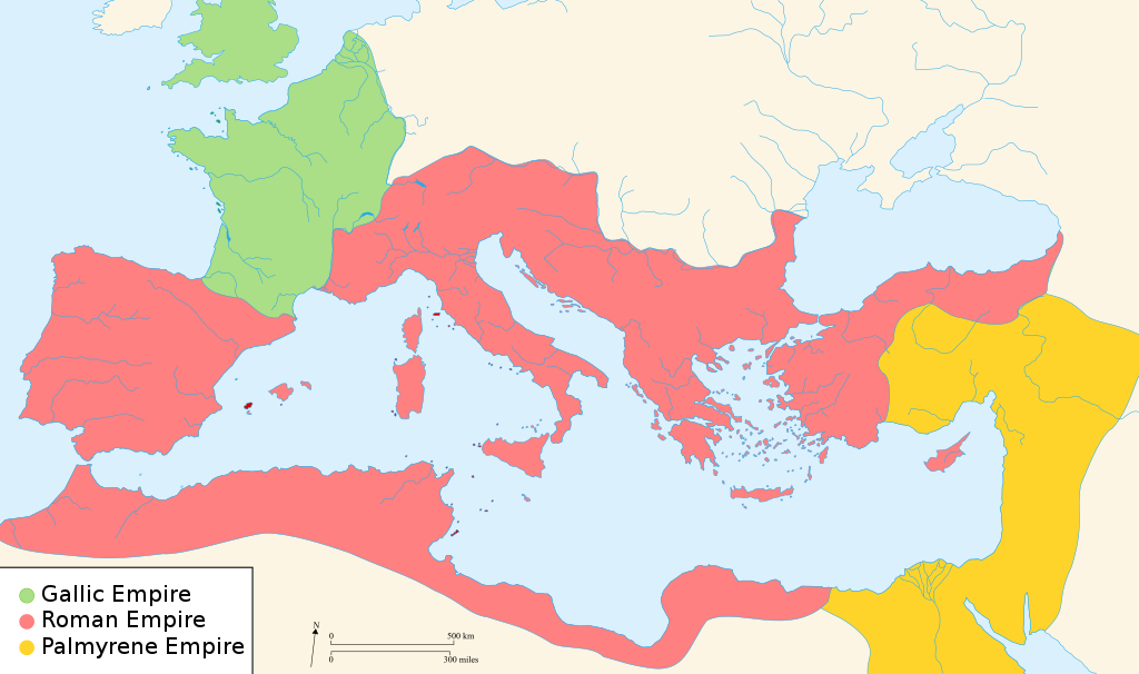
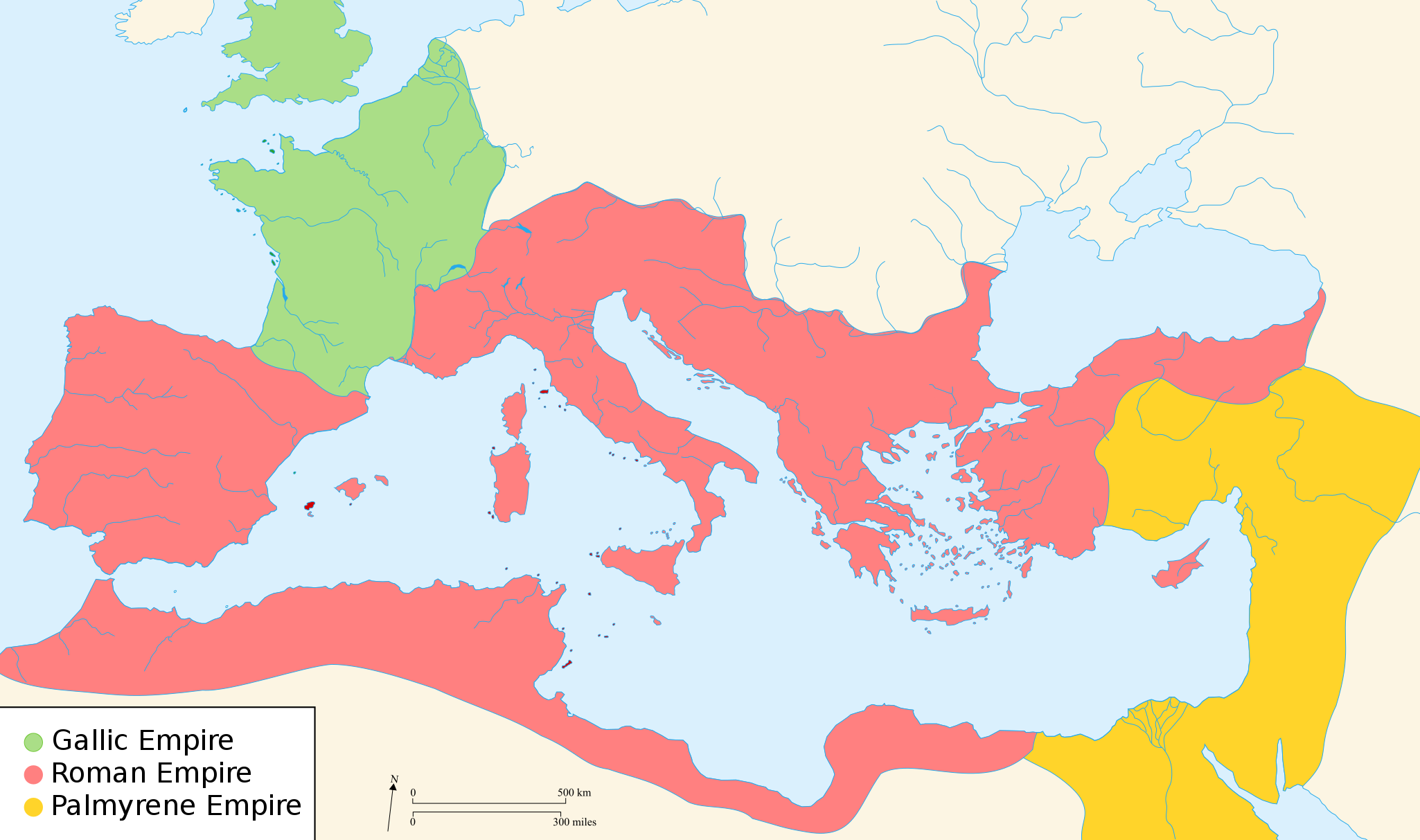
English: Map of the Roman Empire around the year of the consulship of Aurelianus and Bassus (271 AD), with the break away Gallic Empire in the West and the Palmyrene Empire in the East. |
||
| Date | (UTC) | ||
| Source | |||
| Author |
|
||
| Permission (Reusing this file) |
I, the copyright holder of this work, hereby publish it under the following licenses:
This file is licensed under the Creative Commons Attribution-Share Alike 2.5 Generic, 2.0 Generic and 1.0 Generic license.
You may select the license of your choice. |
||
| Other versions |
[]
|


.svg)


| This SVG file contains embedded text that can be translated into your language, using any capable SVG editor, text editor or the SVG Translate tool. For more information see: About translating SVG files. |
Licensing

|
Permission is granted to copy, distribute and/or modify this document under the terms of the GNU Free Documentation License, Version 1.2 or any later version published by the Free Software Foundation; with no Invariant Sections, no Front-Cover Texts, and no Back-Cover Texts. A copy of the license is included in the section entitled GNU Free Documentation License. Subject to disclaimers. |
Original upload log
The original description page was here. All following user names refer to en.wikipedia.
- 2007-11-07 02:47 Justinian43 524×377×8 (26490 bytes) The Mediterranean by 271 A.D -The [[Roman Empire]]. -The breakaway [[Gallic Empire]]. -The breakaway [[Palmyrene Empire]].
- derivative work: Pomalee (talk)
other_versions=Derivative works of this file: Map of Ancient Rome 271 AD-sr.svg Permission= GNU Free Documentation License, Version 1.2, Creative Commons Attribution-ShareAlike license versions 3.0, 2.5, 2.0, and 1.0
- Romanworld271AD.jpg: User:Justinian43, uploaded by User:El_bes
| This is a retouched picture, which means that it has been digitally altered from its original version. Modifications: Used "Blank_map_of_South_Europe_and_North_Africa.svg" to refashion "Romanworld271.jpg". The original can be viewed here: Romanworld271AD.jpg:
|

|
Permission is granted to copy, distribute and/or modify this document under the terms of the GNU Free Documentation License, Version 1.2 or any later version published by the Free Software Foundation; with no Invariant Sections, no Front-Cover Texts, and no Back-Cover Texts. A copy of the license is included in the section entitled GNU Free Documentation License. |
| This file is licensed under the Creative Commons Attribution-Share Alike 3.0 Unported license. | ||
| ||
| This licensing tag was added to this file as part of the GFDL licensing update. |
Original upload log
This image is a derivative work of the following images:
- File:Blank_map_of_South_Europe_and_North_Africa.svg licensed with Cc-by-sa-2.5,2.0,1.0, GFDL
- 2007-08-09T20:26:49Z Historicair 2050x1213 (1260388 Bytes)
- 2007-08-09T16:12:00Z Historicair 2050x1213 (351130 Bytes) {{Improving}} {{Information |Description={{fr}}Carte vierge de l'Europe du Sud et du Bassin Méditerranée dans l'Antiquité {{en}}Blank map of South Europe and North Africa at Antic period |Source=Own work + [[Image:Blank map of South Europe and North Africa.svg]] by myself
- File:Romanworld271AD.jpg licensed with GFDL-en
- 2007-11-20T15:23:56Z El bes 524x377 (26490 Bytes) {{Information |Description= The Roman Empire around the year 271 AD, with the break awai Gallic Empire in the West |Source= http://en.wikipedia.org/wiki/Image:Romanworld271AD.JPG |Date= November 20th, 2007 |Author= [[http://e
Uploaded with derivativeFX
File history
Click on a date/time to view the file as it appeared at that time.
| Date/Time | Thumbnail | Dimensions | User | Comment | |
|---|---|---|---|---|---|
| current | 22:07, 20 March 2022 | | 2,050 × 1,213 (207 KB) | wikimediacommons>Leptictidium | File uploaded using svgtranslate tool (https://svgtranslate.toolforge.org/). Added translation for ca. |
File usage
The following 9 pages use this file: