File:Map of Arizona highlighting La Paz County.svg

Size of this PNG preview of this SVG file: 487 × 599 pixels. Other resolutions: 195 × 240 pixels | 390 × 480 pixels | 624 × 768 pixels | 832 × 1,024 pixels | 1,664 × 2,048 pixels | 893 × 1,099 pixels.
Original file (SVG file, nominally 893 × 1,099 pixels, file size: 260 KB)
| This is a file from the Wikimedia Commons. Information from its description page there is shown below. Commons is a freely licensed media file repository. You can help. |
Summary
| Description |
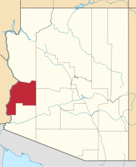
English: Locator map of La Paz County in Arizona. |
||
| Date | |||
| Source | v.1: David Benbennick; v.2: File:USA Arizona location map.svg | ||
| Author | Own work. | ||
| Permission (Reusing this file) |
|
||
| Other versions | |||
| Commons images used |
- For more information, see Commons:United States county locator maps.
File history
Click on a date/time to view the file as it appeared at that time.
| Date/Time | Thumbnail | Dimensions | User | Comment | |
|---|---|---|---|---|---|
| current | 23:06, 28 February 2015 | | 893 × 1,099 (260 KB) | wikimediacommons>Sumiaz | Newer version based on File:USA Arizona location map.svg |
File usage
The following 31 pages use this file:
- Bluewater, Arizona
- Bouse, Arizona
- Bradshaw's Ferry
- Brenda, Arizona
- Cibola, Arizona
- Clip, Arizona
- Colorado River Indian Tribes
- Deer Island (Arizona and California)
- Drift Desert, Arizona
- Ehrenberg, Arizona
- Empire Flat, Arizona
- Eureka Landing, Arizona
- Fort Tyson
- Hope, Arizona
- La Paz, Arizona
- La Paz County, Arizona
- List of counties in Arizona
- Mineral City, Arizona
- Nortons Landing, Arizona
- Olive City, Arizona
- Palo Verde Intake
- Parker, Arizona
- Parker Strip, Arizona
- Planet, Arizona
- Plomosa, Arizona
- Poston, Arizona
- Quartzsite, Arizona
- Salome, Arizona
- Wenden, Arizona
- Williamsport, Arizona
- Template:La Paz County, Arizona