
File:Map of the Black Sea with bathymetry and surrounding relief.svg

Size of this PNG preview of this SVG file: 800 × 508 pixels. Other resolutions: 320 × 203 pixels | 640 × 406 pixels | 1,024 × 650 pixels | 1,280 × 812 pixels | 2,560 × 1,625 pixels | 1,013 × 643 pixels.
Original file (SVG file, nominally 1,013 × 643 pixels, file size: 8.35 MB)
| This is a file from the Wikimedia Commons. Information from its description page there is shown below. Commons is a freely licensed media file repository. You can help. |
Summary
| Description |
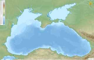
English: Map of the w:Black Sea with bathymetry and surrounding relief.
ქართული: შავი ზღვის რუკა სიღრმის მაჩვენებლებითა და მიდამოების რელიეფით.
Mercator projection. Geographic limits of the map:
|
| Date | |
| Source | Own work |
| Author | Giorgi Balakhadze |
Licensing
Giorgi Balakhadze at English Wikipedia, the copyright holder of this work, hereby publishes it under the following license:
This file is licensed under the Creative Commons Attribution-Share Alike 4.0 International license.
Attribution: Giorgi Balakhadze at English Wikipedia
- You are free:
- to share – to copy, distribute and transmit the work
- to remix – to adapt the work
- Under the following conditions:
- attribution – You must give appropriate credit, provide a link to the license, and indicate if changes were made. You may do so in any reasonable manner, but not in any way that suggests the licensor endorses you or your use.
- share alike – If you remix, transform, or build upon the material, you must distribute your contributions under the same or compatible license as the original.
Original upload log
The original description page was here. All following user names refer to en.wikipedia.
| Date/Time | Dimensions | User | Comment |
|---|---|---|---|
| 2016-06-21 15:17:32 | 1013× 643× | Giorgi Balakhadze | fix |
| 2016-06-21 15:12:26 | 1013× 643× | Giorgi Balakhadze | {{Information |Description={{en|Map of the [[Black Sea]] with bathymetry and surrounding relief.}} </br>Mercator projection. Geographic limits of the map: * N: 47.594° N * S: 40.548° N * W: 26.825° E * E: 42.242° E *SRTM WED 3-arc second *ETOPO1 Be... |
File history
Click on a date/time to view the file as it appeared at that time.
| Date/Time | Thumbnail | Dimensions | User | Comment | |
|---|---|---|---|---|---|
| current | 04:49, 23 June 2016 | | 1,013 × 643 (8.35 MB) | wikimediacommons>OgreBot | (BOT): Reverting to most recent version before archival |
File usage
The following 22 pages use this file:
- 1986 Black Sea incident
- 1988 Black Sea bumping incident
- Battle of Sinop
- Battle of Varna
- Batumi International Airport
- Black Sea
- Burgas
- Dnieper–Bug estuary
- Kalamita Bay
- Kerch Strait incident
- Krasnoperekopsk
- Maican Island
- Ordu
- Perekop
- Pitsunda
- Sabiha Gökçen International Airport
- Sakarya gas field
- Sea of Azov
- Snake Island campaign
- Trabzon
- Varna, Bulgaria
- Varna Airport