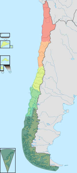
File:Natural Regions of Chile.svg

Size of this PNG preview of this SVG file: 267 × 600 pixels. Other resolutions: 107 × 240 pixels | 213 × 480 pixels | 342 × 768 pixels | 455 × 1,024 pixels | 911 × 2,048 pixels | 1,183 × 2,658 pixels.
Original file (SVG file, nominally 1,183 × 2,658 pixels, file size: 1.16 MB)
| This is a file from the Wikimedia Commons. Information from its description page there is shown below. Commons is a freely licensed media file repository. You can help. |
Summary
| Description |
Español: Mapa de las regiones naturales de Chile. |
| Date | |
| Source |
This file was derived from: |
| Author |
|
| Other versions |
,_administrative_divisions_(CORFO_regions)_-_Nmbrs_-_colored_2018.svg) |
.svg)
Licensing
This file is licensed under the Creative Commons Attribution-ShareAlike 3.0 Chile license.
- You are free:
- to share – to copy, distribute and transmit the work
- to remix – to adapt the work
- Under the following conditions:
- attribution – You must give appropriate credit, provide a link to the license, and indicate if changes were made. You may do so in any reasonable manner, but not in any way that suggests the licensor endorses you or your use.
- share alike – If you remix, transform, or build upon the material, you must distribute your contributions under the same or compatible license as the original.

File history
Click on a date/time to view the file as it appeared at that time.
| Date/Time | Thumbnail | Dimensions | User | Comment | |
|---|---|---|---|---|---|
| current | 23:37, 15 August 2023 | | 1,183 × 2,658 (1.16 MB) | wikimediacommons>Janitoalevic | Arreglo límite entre la zona centro y la zona sur. |
File usage
The following 3 pages use this file: