
File:Rossendale UK local election 2019 map.svg

Size of this PNG preview of this SVG file: 636 × 600 pixels. Other resolutions: 255 × 240 pixels | 509 × 480 pixels | 814 × 768 pixels | 1,086 × 1,024 pixels | 2,172 × 2,048 pixels | 1,385 × 1,306 pixels.
Original file (SVG file, nominally 1,385 × 1,306 pixels, file size: 280 KB)
| This is a file from the Wikimedia Commons. Information from its description page there is shown below. Commons is a freely licensed media file repository. You can help. |
Any autoconfirmed user can overwrite this file from the same source. Please ensure that overwrites comply with the guideline.
Summary
| Description |
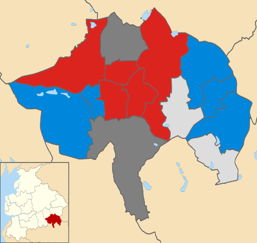
English: Labour Party (UK): 5 Conservative Party (UK): 5 Independent (politician): 2 Wards in dark grey were not contested in 2019 |
| Date | |
| Source |
This file was derived from: Rossendale UK ward map 2010 (blank).svg: |
| Author |
Rossendale_UK_ward_map_2010_(blank).svg: Nilfanion, created using Ordnance Survey data
|
.svg)
Licensing
This file is licensed under the Creative Commons Attribution-Share Alike 4.0 International license.
- You are free:
- to share – to copy, distribute and transmit the work
- to remix – to adapt the work
- Under the following conditions:
- attribution – You must give appropriate credit, provide a link to the license, and indicate if changes were made. You may do so in any reasonable manner, but not in any way that suggests the licensor endorses you or your use.
- share alike – If you remix, transform, or build upon the material, you must distribute your contributions under the same or compatible license as the original.
File history
Click on a date/time to view the file as it appeared at that time.
| Date/Time | Thumbnail | Dimensions | User | Comment | |
|---|---|---|---|---|---|
| current | 13:28, 14 May 2025 | | 1,385 × 1,306 (280 KB) | wikimediacommons>Alextheconservative | Community First colour |
File usage
The following page uses this file: