
File:Seven second summits map-fr.svg

Size of this PNG preview of this SVG file: 800 × 406 pixels. Other resolutions: 320 × 163 pixels | 640 × 325 pixels | 1,024 × 520 pixels | 1,280 × 650 pixels | 2,560 × 1,300 pixels | 1,636 × 831 pixels.
Original file (SVG file, nominally 1,636 × 831 pixels, file size: 4.11 MB)
| This is a file from the Wikimedia Commons. Information from its description page there is shown below. Commons is a freely licensed media file repository. You can help. |
Summary
| Description |
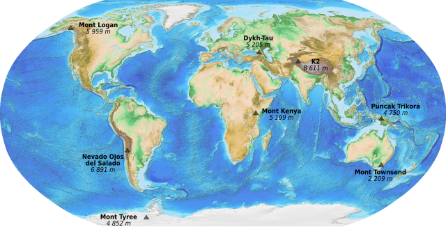
English: Map of the Seven Second Summits. French version.
Français : Carte des Sept seconds sommets (secondes plus hautes montagnes de chaque continent). |
||
| Date | (UTC) | ||
| Source |
|
||
| Author | Sémhur (talk) | ||
| Other versions | |||
| Attribution (required by the license) | © Sémhur / Wikimedia Commons / | ||
| SVG | W3C-validity not checked.
|
||
| Graphic Lab |
Licensing
This image is in the public domain because it contains materials that originally came from the U.S. National Oceanic and Atmospheric Administration, taken or made as part of an employee's official duties.
|
File history
Click on a date/time to view the file as it appeared at that time.
| Date/Time | Thumbnail | Dimensions | User | Comment | |
|---|---|---|---|---|---|
| current | 22:28, 22 October 2010 | | 1,636 × 831 (4.11 MB) | wikimediacommons>Sémhur | == {{int:filedesc}} == {{Information |Description={{en|1=Map of the Seven Second Summits. French version.}} {{fr|1=Carte des Sept seconds sommets (secondes plus hautes montagnes de chaque continent |
File usage
The following page uses this file: