File:Sicily prehellenic topographic map.svg

Size of this PNG preview of this SVG file: 800 × 533 pixels. Other resolutions: 320 × 213 pixels | 640 × 427 pixels | 1,024 × 683 pixels | 1,280 × 853 pixels | 2,560 × 1,707 pixels | 2,373 × 1,582 pixels.
Original file (SVG file, nominally 2,373 × 1,582 pixels, file size: 3.55 MB)
| This is a file from the Wikimedia Commons. Information from its description page there is shown below. Commons is a freely licensed media file repository. You can help. |
Summary
| Description |
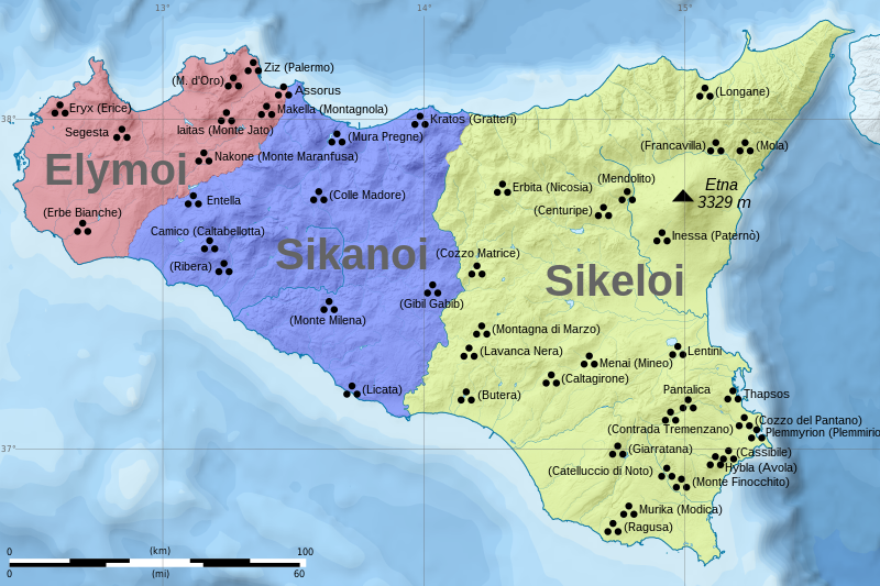
English: The map shows the most important archaeological sites of Sicily related to pre-hellenic cultures, as well as the possible extent of the cultures of Sicani, Siceli and Elymians. Note that the borders shown are merely approximate, and resemble the situation of VI century BC, when there already were foreign colonies present on the island. Historical names where known, modern Italian names in brackets.
Map self-made in Inkscape, based on the following files:
Polski: Mapa przedstawiająca najważniejsze stanowiska archeologiczne z okresu przedhelleńskiego na Sycylii, oraz przypuszczalny zasięg trzech kultur sycylijskich: Sykanów, Sykulów i Elimian. Nazwy historyczne (jeśli znane), współczesne nazwy włoskie w nawiasach.
Uwaga: granice są czysto orientacyjne, przedstawiają mniej więcej zasięg poszczególnych kultur w VI wieku p.n.e. Mapa wykonana w programie Inkscape na podstawie:
|
| Date | |
| Source | Own work |
| Author | Halibutt |
Licensing
I, the copyright holder of this work, hereby publish it under the following license:
This file is licensed under the Creative Commons Attribution-Share Alike 4.0 International license.
- You are free:
- to share – to copy, distribute and transmit the work
- to remix – to adapt the work
- Under the following conditions:
- attribution – You must give appropriate credit, provide a link to the license, and indicate if changes were made. You may do so in any reasonable manner, but not in any way that suggests the licensor endorses you or your use.
- share alike – If you remix, transform, or build upon the material, you must distribute your contributions under the same or compatible license as the original.
File history
Click on a date/time to view the file as it appeared at that time.
| Date/Time | Thumbnail | Dimensions | User | Comment | |
|---|---|---|---|---|---|
| current | 23:00, 22 January 2023 | | 2,373 × 1,582 (3.55 MB) | wikimediacommons>A09 | File uploaded using svgtranslate tool (https://svgtranslate.toolforge.org/). Added translation for sl. |
File usage
The following 4 pages use this file: