File:Trolleybus Winterthur Netz.svg

Size of this PNG preview of this SVG file: 682 × 600 pixels. Other resolutions: 273 × 240 pixels | 546 × 480 pixels | 873 × 768 pixels | 1,164 × 1,024 pixels | 2,328 × 2,048 pixels | 4,349 × 3,826 pixels.
Original file (SVG file, nominally 4,349 × 3,826 pixels, file size: 336 KB)
| This is a file from the Wikimedia Commons. Information from its description page there is shown below. Commons is a freely licensed media file repository. You can help. |
Summary
| Description |
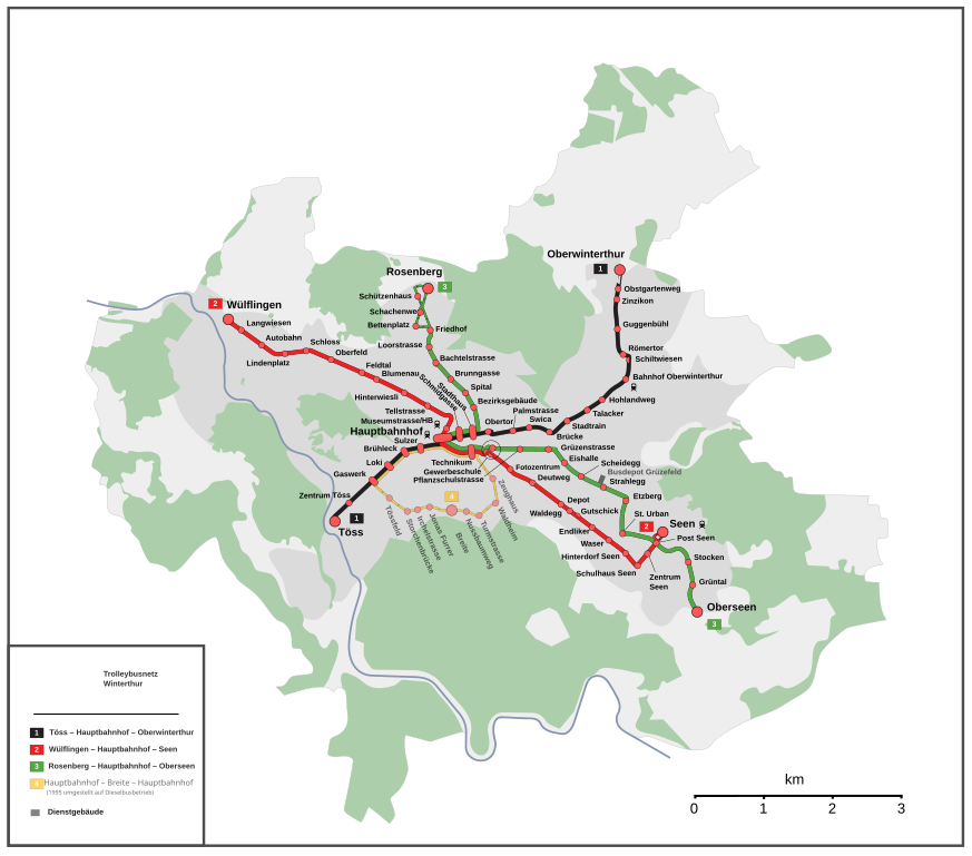
English: Map of the Winterthur trolleybus system
Deutsch: Karte des Trolleybusnetzes Winterthur |
| Date | |
| Source |
Own work Map was created using: |
| Author | Pechristener |
| Permission (Reusing this file) |
Map data (c) OpenStreetMap (and) contributors, CC-BY-SA |
Licensing
This file is licensed under the Creative Commons Attribution-Share Alike 2.0 Generic license.
- You are free:
- to share – to copy, distribute and transmit the work
- to remix – to adapt the work
- Under the following conditions:
- attribution – You must give appropriate credit, provide a link to the license, and indicate if changes were made. You may do so in any reasonable manner, but not in any way that suggests the licensor endorses you or your use.
- share alike – If you remix, transform, or build upon the material, you must distribute your contributions under the same or compatible license as the original.
File history
Click on a date/time to view the file as it appeared at that time.
| Date/Time | Thumbnail | Dimensions | User | Comment | |
|---|---|---|---|---|---|
| current | 00:13, 24 December 2013 | | 4,349 × 3,826 (336 KB) | wikimediacommons>Pechristener | Dättnau war schon vorher drin + die anderen Korrekturen |
File usage
The following page uses this file: