Frankenberg, Hesse
Frankenberg an der Eder is a town in Waldeck-Frankenberg district, Hesse, Germany.
Frankenberg | |
|---|---|
_Altstadt.jpg) Frankenberg | |
_COA.svg) Coat of arms | |
Location of Frankenberg within Waldeck-Frankenberg district <imagemap>File: Frankenberg (Eder) in KB.svg | 240x240px poly 537 2091 653 2091 669 2117 757 2117 755 2151 729 2161 765 2209 761 2255 783 2261 785 2291 715 2293 703 2365 747 2391 713 2407 619 2405 623 2363 575 2369 567 2377 451 2373 367 2287 441 2217 479 2137 543 2127 543 2091 Hatzfeld poly 501 1913 517 1947 445 2019 471 2045 513 2015 541 2093 651 2093 671 2117 755 2115 759 2153 729 2161 765 2213 765 2259 787 2263 785 2291 711 2291 707 2367 745 2387 837 2351 839 2309 879 2307 879 2265 935 2211 961 2229 1005 2217 1023 2165 991 2173 957 2111 871 2127 791 2043 805 2019 757 1995 745 2007 701 2005 669 1907 641 1895 601 1901 555 1877 Battenberg poly 503 1910 441 1893 454 1827 503 1778 565 1778 582 1741 652 1741 871 1798 912 1757 929 1807 908 1840 933 1869 892 1856 887 1889 954 1980 1024 1980 1065 1964 1086 1988 1082 2034 1036 2059 1049 2083 1007 2096 1040 2120 1024 2158 987 2162 958 2137 945 2100 892 2120 846 2108 830 2075 776 2034 805 1997 755 1988 731 2005 689 1997 677 1906 627 1889 602 1893 582 1873 532 1873 Allendorf (Eder) poly 1005 2221 1041 2127 1023 2103 1043 2103 1053 2087 1043 2071 1069 2061 1097 2045 1149 2079 1217 2075 1229 2051 1275 2051 1303 2027 1321 2047 1335 2047 1349 2033 1375 2049 1349 2079 1353 2111 1401 2113 1401 2099 1437 2099 1439 2107 1451 2109 1449 2095 1483 2101 1473 2125 1479 2139 1463 2153 1423 2139 1391 2143 1389 2159 1335 2181 1339 2209 1319 2199 1209 2197 1155 2209 1157 2239 1113 2249 1099 2283 1043 2289 999 2259 1023 2169 1045 2125 1021 2105 1039 2103 1051 2085 1039 2067 1069 2063 Burgwald poly 1095 2281 1111 2251 1155 2235 1153 2217 1175 2203 1307 2195 1335 2213 1337 2181 1387 2159 1393 2139 1425 2135 1463 2151 1483 2183 1491 2225 1517 2227 1515 2251 1589 2297 1557 2317 1577 2341 1565 2381 1413 2347 1395 2367 1261 2371 1197 2341 1213 2313 1179 2285 1111 2337 1065 2319 Rosenthal poly 1461 2149 1477 2143 1527 2173 1529 2139 1569 2121 1611 2131 1669 2125 1685 2111 1711 2149 1725 2145 1741 2163 1761 2133 1799 2145 1777 2167 1799 2211 1885 2187 1909 2229 1851 2269 1863 2287 1839 2313 1859 2319 1867 2361 1891 2371 1883 2445 1747 2449 1721 2407 1657 2381 1643 2333 1587 2301 1519 2257 1519 2227 1487 2225 Gemünden (Wohra) poly 1461 2093 1455 2051 1541 2015 1573 2033 1577 2015 1611 1995 1609 1893 1651 1873 1673 1881 1743 1855 1769 1859 1801 1847 1919 1927 1921 1957 1963 2031 1997 2021 2021 2037 2043 2015 2067 2025 2055 2059 2079 2089 1907 2229 1885 2189 1801 2213 1775 2171 1799 2145 1759 2133 1745 2159 1729 2145 1707 2149 1689 2109 1677 2103 1663 2125 1573 2121 1553 2137 1529 2141 1529 2173 1475 2141 1485 2099 Haina poly 919 1771 917 1807 931 1821 923 1847 937 1885 905 1869 901 1905 963 1989 1005 1983 1029 1991 1071 1979 1099 2005 1097 2047 1149 2075 1217 2079 1227 2053 1267 2053 1293 2029 1311 2029 1323 2047 1345 2037 1371 2047 1351 2079 1359 2111 1397 2111 1401 2099 1435 2099 1441 2111 1451 2111 1451 2097 1463 2095 1455 2049 1547 2017 1571 2033 1575 2011 1609 1993 1605 1953 1565 1959 1563 1947 1529 1941 1505 1959 1473 1929 1505 1911 1477 1901 1457 1863 1471 1857 1461 1827 1395 1815 1365 1795 1415 1775 1397 1757 1419 1737 1415 1723 1359 1687 1329 1697 1321 1709 1305 1705 1271 1765 1211 1763 1179 1713 1151 1711 1147 1695 1131 1697 1129 1709 1085 1707 1017 1749 969 1735 Frankenberg poly 1417 1721 1415 1735 1397 1755 1419 1769 1363 1797 1395 1813 1459 1827 1471 1857 1457 1861 1473 1903 1505 1909 1475 1929 1501 1963 1527 1941 1567 1943 1565 1961 1613 1953 1609 1899 1657 1875 1675 1885 1749 1857 1775 1859 1797 1843 1753 1809 1741 1765 1701 1737 1699 1715 1723 1697 1727 1677 1705 1639 1715 1623 1697 1607 1695 1561 1675 1561 1649 1587 1609 1585 1613 1611 1567 1613 1543 1623 1531 1647 1557 1655 1559 1737 1539 1745 1483 1711 1457 1723 Frankenau poly 1721 1671 1789 1689 1819 1689 1829 1717 1897 1727 1897 1683 1937 1687 1937 1669 1963 1661 1983 1681 2001 1681 2005 1647 2041 1637 2045 1617 2087 1615 2107 1593 2119 1611 2143 1611 2145 1597 2175 1595 2191 1633 2213 1621 2233 1637 2277 1625 2343 1631 2403 1647 2423 1667 2377 1713 2381 1743 2311 1821 2265 1823 2291 1853 2273 1881 2239 1897 2235 1933 2199 1969 2181 1967 2151 1983 2099 1985 2107 2067 2085 2079 2055 2055 2063 2025 2043 2015 2025 2037 2001 2019 1959 2027 1921 1959 1923 1927 1743 1801 1741 1753 1695 1717 1723 1693 Bad Wildungen poly 1167 1317 1191 1329 1173 1353 1137 1359 1133 1433 1145 1449 977 1643 1007 1713 1061 1717 1083 1709 1131 1711 1133 1699 1147 1697 1151 1711 1187 1713 1209 1767 1267 1765 1299 1709 1327 1707 1319 1673 1339 1671 1337 1619 1399 1561 1413 1545 1423 1495 1411 1475 1451 1459 1451 1421 1495 1339 1477 1275 1429 1263 1403 1277 1367 1277 1347 1247 1339 1247 1335 1257 1313 1257 1315 1239 1299 1239 1273 1221 1245 1241 1189 1247 1191 1283 1161 1301 Lichtenfels poly 1091 1107 1075 1155 1079 1181 1069 1197 1095 1221 1099 1257 1143 1321 1171 1321 1169 1285 1193 1281 1187 1247 1233 1241 1271 1217 1313 1253 1329 1253 1337 1245 1353 1245 1351 1259 1365 1275 1469 1269 1495 1239 1467 1191 1487 1177 1535 1177 1561 1211 1603 1211 1651 1239 1701 1239 1711 1171 1693 1147 1713 1133 1713 1113 1691 1105 1667 1073 1671 1043 1665 1017 1683 1003 1673 985 1637 969 1599 987 1553 963 1527 967 1493 949 1469 917 1489 883 1517 863 1483 827 1443 825 1423 865 1429 897 1415 907 1359 905 1351 915 1229 913 1221 931 1199 923 1199 981 1171 981 1215 1049 1205 1071 1163 1059 1147 1097 Korbach poly 861 793 823 779 739 855 743 895 591 1033 637 1087 677 1095 693 1165 777 1175 813 1121 911 1103 961 1083 965 1055 1055 1059 1047 1095 1095 1113 1141 1099 1157 1059 1209 1067 1207 1045 1163 969 1111 949 1073 951 1025 883 971 879 941 893 895 857 Willingen poly 859 793 889 737 943 701 939 667 989 635 1093 659 1111 635 1155 635 1271 579 1343 615 1373 597 1417 627 1499 577 1643 579 1643 619 1621 611 1599 631 1585 631 1507 693 1509 717 1455 747 1447 769 1483 807 1483 825 1451 827 1425 855 1433 893 1423 903 1361 905 1353 915 1227 911 1223 933 1201 919 1197 977 1171 979 1149 961 1113 949 1073 949 1019 879 979 879 933 891 899 867 Diemelsee poly 1589 353 1659 353 1701 341 1709 343 1709 361 1751 399 1779 391 1791 361 1811 357 1813 373 1841 373 1847 339 1913 391 1969 385 1969 369 1997 339 1973 283 1973 269 2021 265 2051 177 2065 159 2027 119 1987 129 1917 113 1875 49 1737 97 1669 137 1545 163 1511 219 1519 249 1567 269 Diemelstadt poly 1469 1271 1491 1241 1489 1221 1467 1193 1481 1177 1531 1175 1559 1209 1601 1207 1647 1237 1705 1237 1707 1287 1737 1307 1775 1295 1795 1309 1797 1375 1767 1401 1733 1423 1711 1437 1713 1481 1747 1493 1755 1533 1701 1565 1679 1563 1659 1575 1649 1583 1605 1587 1613 1613 1573 1615 1545 1625 1529 1647 1559 1651 1559 1737 1521 1743 1487 1709 1461 1721 1405 1723 1369 1687 1323 1699 1313 1675 1333 1671 1337 1619 1399 1567 1425 1491 1415 1473 1447 1461 1451 1425 1495 1325 Vöhl poly 2019 267 1981 267 1973 285 1997 337 1969 381 1919 387 1915 431 1905 447 1911 527 1933 561 1971 555 2013 577 2027 559 2057 591 2057 643 2095 687 2203 657 2205 689 2229 701 2253 735 2305 687 2281 659 2313 653 2319 619 2273 579 2263 531 2229 519 2203 483 2245 481 2267 465 2229 457 2253 441 2251 353 2211 357 2155 339 2111 363 2057 355 2047 293 Volkmarsen poly 1589 355 1587 401 1677 417 1679 487 1647 493 1639 617 1661 649 1647 669 1647 687 1673 689 1775 755 1807 797 1833 769 1831 803 1879 807 1901 803 1925 813 1925 841 1917 851 1943 893 1977 915 2011 917 2013 987 2047 1001 2051 1015 2039 1019 2053 1033 2051 1069 2067 1081 2161 1059 2161 1031 2121 991 2123 889 2129 851 2097 845 2099 815 2171 763 2133 751 2091 689 2051 645 2063 595 2049 575 2029 561 2009 577 1973 553 1929 563 1905 527 1909 461 1905 449 1919 427 1919 393 1849 339 1847 369 1821 377 1811 357 1789 371 1781 391 1753 397 1709 367 1705 341 1663 353 Bad Arolsen poly 1641 617 1661 653 1645 663 1647 687 1669 687 1775 751 1801 801 1829 767 1833 799 1879 807 1903 799 1929 819 1915 845 1943 895 1929 925 1909 939 1875 939 1869 969 1835 953 1799 967 1793 947 1753 955 1715 997 1711 1009 1683 1003 1679 981 1631 967 1591 989 1553 963 1517 969 1479 939 1473 915 1487 883 1515 857 1485 825 1485 815 1451 777 1451 747 1509 719 1505 697 1595 625 Twistetal poly 1681 1003 1709 1009 1749 955 1801 945 1797 965 1839 955 1867 967 1877 937 1917 935 1941 893 1977 913 2013 917 2017 985 2051 999 2053 1019 2043 1021 2053 1039 2053 1071 2077 1089 2105 1155 2171 1171 2161 1279 2141 1285 2123 1329 2127 1349 2051 1371 2061 1403 1975 1405 1991 1369 1959 1359 1931 1383 1893 1373 1869 1381 1831 1359 1849 1319 1829 1311 1817 1377 1861 1423 1855 1433 1793 1415 1723 1487 1711 1435 1795 1373 1801 1315 1769 1297 1737 1303 1705 1281 1705 1239 1715 1177 1693 1147 1717 1129 1715 1111 1691 1101 1667 1069 1671 1049 1667 1013 Waldeck poly 1721 1483 1797 1413 1855 1435 1863 1421 1821 1383 1817 1321 1843 1311 1853 1323 1829 1353 1861 1377 1895 1371 1927 1381 1953 1361 1987 1361 1989 1375 1975 1403 2059 1401 2055 1361 2123 1349 2133 1289 2163 1283 2195 1297 2285 1383 2287 1445 2339 1497 2339 1527 2299 1545 2339 1549 2331 1573 2393 1631 2441 1643 2425 1663 2399 1643 2323 1629 2247 1629 2231 1635 2217 1619 2199 1635 2177 1597 2149 1599 2147 1609 2119 1609 2113 1595 2089 1611 2047 1613 2037 1637 2007 1639 2003 1685 1985 1681 1961 1663 1937 1671 1939 1689 1903 1687 1903 1721 1829 1719 1823 1691 1775 1689 1723 1675 1705 1647 1717 1617 1697 1609 1695 1563 1753 1537 1753 1499 1721 1485 Edertal poly 2475 118 2432 211 2412 288 2339 274 2273 304 2246 357 2114 360 2051 347 2051 291 2017 268 2034 238 2051 178 2071 161 2021 115 1991 132 1951 128 1878 42 1547 161 1503 218 1510 251 1566 268 1593 407 1673 420 1669 483 1636 490 1633 579 1503 563 1414 619 1364 589 1328 609 1261 573 1149 629 1109 629 1092 659 986 632 936 666 936 689 887 732 853 792 820 782 731 858 734 898 595 1037 621 1090 678 1090 694 1170 787 1173 807 1127 959 1087 973 1054 1056 1057 1042 1097 1089 1113 1069 1210 1095 1226 1102 1263 1149 1319 1178 1319 1172 1349 1139 1352 1132 1438 1135 1462 969 1647 1003 1714 1052 1717 1019 1744 976 1734 873 1803 664 1753 634 1770 598 1747 575 1777 535 1787 452 1846 452 1896 502 1906 508 1946 442 2016 472 2045 512 2022 552 2112 479 2135 439 2201 419 2241 372 2274 379 2317 362 2354 366 2384 339 2470 4 2470 14 -1 2469 3 North Rhine-Westphalia poly 2472 119 2432 178 2422 284 2349 278 2263 308 2250 351 2250 440 2230 457 2256 460 2240 477 2207 480 2220 517 2263 523 2266 576 2319 613 2309 653 2283 656 2303 689 2253 732 2203 692 2203 656 2100 679 2117 742 2167 759 2094 815 2097 845 2117 845 2130 988 2153 1024 2160 1054 2071 1080 2110 1160 2170 1170 2163 1279 2193 1296 2283 1379 2286 1449 2336 1505 2445 1432 2445 1382 2475 1359 Kassel (district) poly 2475 1359 2449 1386 2445 1429 2336 1492 2346 1518 2306 1541 2336 1548 2333 1565 2382 1628 2442 1641 2266 1823 2286 1857 2266 1886 2240 1893 2230 1936 2200 1966 2180 1966 2147 1989 2100 1989 2100 2072 2008 2172 1905 2218 1885 2248 1852 2261 1862 2321 1858 2361 1882 2364 1882 2440 1915 2473 2472 2450 Schwalm-Eder-Kreis poly 339 2473 366 2354 389 2314 445 2371 561 2377 565 2367 621 2364 618 2404 717 2410 840 2344 837 2308 880 2308 883 2261 930 2211 963 2228 1003 2221 1003 2264 1042 2291 1086 2281 1066 2321 1105 2337 1185 2288 1212 2314 1198 2334 1215 2361 1387 2364 1404 2347 1563 2384 1576 2351 1547 2311 1586 2311 1643 2334 1646 2371 1683 2400 1719 2404 1742 2447 1885 2447 1911 2477 Marburg-Biedenkopf desc bottom-left </imagemap> | |
 Frankenberg  Frankenberg | |
| Coordinates: 51°03′32″N 08°47′48″E / 51.05889°N 8.79667°E | |
| Country | Germany |
| State | Hesse |
| Admin. region | Kassel |
| District | Waldeck-Frankenberg |
| Government | |
| • Mayor (2023–29) | Barbara Eckes[1] (SPD) |
| Area | |
| • Total | 124.87 km2 (48.21 sq mi) |
| Highest elevation | 405 m (1,329 ft) |
| Lowest elevation | 280 m (920 ft) |
| Population (2022-12-31)[2] | |
| • Total | 18,033 |
| • Density | 140/km2 (370/sq mi) |
| Time zone | UTC+01:00 (CET) |
| • Summer (DST) | UTC+02:00 (CEST) |
| Postal codes | 35066 |
| Dialling codes | 06451 |
| Vehicle registration | KB, FKB, WA |
| Website | www.frankenberg.de |
The mountain at a ford over the Eder north of the Burgwald range was for a long time a fortified place, playing an especially important role under the Franks in the Saxon Wars. The town was built in 1233-1234 by the Thuringian Landgrave at the junction of two trade routes. The renovated Old and New Town have many half-timbered houses. In 2018 the town adopted the additional name "Philipp Soldan Stadt".[citation needed]
Geography

Frankenberg lies between the Burgwald range in the south and the Breite Struth (hills) in the northwest, where the river Nemphe empties into the Eder. North of the town, the Nuhne empties into the same river at the constituent community of Schreufa. It is 27 kilometres (17 miles) north of Marburg.
Neighbouring communities
Frankenberg borders in the north on the community of Vöhl, in the east on the town of Frankenau, in the southeast on the community of Haina, in the southwest on the community of Burgwald, in the west on the community of Allendorf, and in the northwest on the town of Lichtenfels (all in Waldeck-Frankenberg).
‡
- Dörnholzhausen, 70 inhabitants
- Friedrichshausen, 384 inhabitants
- Geismar, 1011 inhabitants
- Haubern, 530 inhabitants
- Hommershausen, 169 inhabitants
- Rengershausen, 390 inhabitants
- Rodenbach, 168 inhabitants
- Röddenau, 1737 inhabitants
- Schreufa, 1183 inhabitants
- Viermünden, 804 inhabitants
- Wangershausen, 201 inhabitants
- Willersdorf, 611 inhabitants
Population figures as at 2012
History
At the foot of the mountain on which the town of Frankenberg was built crossed two old military and commercial roads. From the area of the lower Main, from the Burgwald range, came the Weinstraße ("Wine Road"), crossing the Eder through a ford and then going on through the heights on the river's left bank to Westphalia. From the west came the Siegener Straße ("Siegen Road") over the Lahn-Eder watershed, leading round the mountain to the north and further on into Lower Hesse.
Frankish times

After the Hesse area had been swallowed up into the Frankish domains about the year 500, the well-defended mountain became involved in the quarrels of heightened military importance with the Saxons who lived north of the Eder. The mountain had already been fortified by the Franks in earlier times. As the number of Saxon incursions nevertheless rose in the early 8th century, Charles Martel had strong defences built, ensuring their efficacy by maintaining a constant presence there. These measures served during the Saxon Wars (772 to 804) as the base for Frankish counterattacks far inside the Saxons' territory, earning the Weinstraße new importance as a route of advance, connection and supply. After the Saxons had been subjugated and Christianized, the fortification became redundant. The building works, left as they were to decay, kept alive the memory of the Franks.
Town's founding
Whether the mountain was further used for living is not known with any certainty. There might have been storage and trading places for travellers and merchants who were passing through town. Only in the early decades of the 13th century does history once again shed light on "the Frankenberg". The Thuringian-Hessian Landgraves were trying to forge a connection between their holdings in Upper Hesse and those in Lower Hesse by somehow getting around the County of Ziegenhain that lay between them. This plan was at odds with what the Archbishops of Mainz, who were, for their part, also expanding, from the west into the Wohra Valley, had in mind. The Landgrave of Thuringia struck back at the Archbishops decisively. Since the Frankenberg had passed to the Landgraves in 1122 and lay in the Vogtei of the Vögte von Keseberg, he chose, right in the middle of the Mainz county of Battenberg, on the boundary between the court regions of Röddenau and Geismar, to build a castle, and furthermore a town, disregarding all of the local lords' objections.
On the uppermost peak of the mountain, which fell away steeply on three sides, appeared the castle, commanding the whole middle Eder Valley. Onto this was built a ward, which also enclosed the ecclesiastical area. Right behind this, going by exact plans (as can be seen in the town's layout), the town was built. The mountain ridge and the mountainside that dropped so sharply off to the north were embraced by the great marketplace. Splitting the marketplace in two, with the town hall built at its west end, is something that might have been done sometime later. A further intention can be seen beyond simply making the town into a stronghold. This lay in also giving the town economic strength by using its advantageous location on the trade roads. The new town's people were from the surrounding villages and hamlets, having been resettled in town or, in some cases, having voluntarily moved there. In the course of time, 16 former living places around town were forsaken, but many of their names live on in names given fields and meadows. Frankenberg was soon girt by a mighty town wall. Of the 25 towers and gates, only the Hexenturm ("Witches Tower") still stands today; all five town gates have vanished.
Heyday

The new community grew quickly, underpinned by a healthy merchant and craftsman class. It was a sign of the growing prosperity that already in 1286, after the church dependence of Geismar had been broken, building work began on the great Marienkirche (Church of Mary) – now known as the Liebfrauenkirche – which was built using the Elisabethkirche in Marburg as a model. Frankenberg buyers and sellers broadly fostered trade links, as witnessed not only by the weekly markets, but also by the four yearly fairs. The economic upswing also afforded a quick upward cultural development. Already in the 13th century, Frankenberg had a town school (Lateinschule), which reached its greatest heights about 1500. Onto the church, which had been completed in 1353, the Marienkapelle (Mary's Chapel) was built between 1370 and 1380, one of Thyle von Frankenberg's masterworks.
New Town's founding
The steady population growth brought the need for a bigger town, and so, on the Landgrave's initiative, the New Town was established at the foot of the mountain towards the Eder. It rose along the Siegener Straße (a commercial road), even having its own administration, although it was still under the Old Town's church and court, and had no marketplace of its own. Only in 1556 was it united with the Old Town into one municipality.
The Great Fire and its aftermath
On 9 May 1476, a fire broke out that burnt the whole New Town and Old Town down. Even the Liebfrauenkirche was burnt right out. Although the townsfolk promptly tackled the job of building their town over again, Frankenberg, which had hitherto been among Hesse's most important towns, never fully recovered from this catastrophic fire. In 1507, half the New Town burnt down again. The seat of the Amt of Frankenberg, which had existed since the 14th century and which included the town areas of Frankenberg and Frankenau as well as half the court region of Geismar, was relocated to the Wolkersdorf Hunting Lodge, itself built on the site of an old moat-ringed castle. Thus was born the Amt of Wolkersdorf, to which belonged the Röddenau lower courts (with the amalgamated courts of Rengershausen and Bromskirchen) and the Geismar court (the "Ämmetche"). Only in the 16th century was there once again an Amt of Frankenberg under which were united not only the town but also Rodenbach farm and the Wiesenfeld wine cellars. The Amt was united with the Amt of Wolkersdorf in 1604.
Frankenberg in the 16th, 17th and 18th centuries
.jpg)

In the 16th century, the town was built anew. Only the Steinhaus ("Stone House") had withstood the fire right up to the roof. Building work on the stately new town hall, which is still the town's landmark today, was begun in 1509. After 1526, as was true throughout Hesse, the Reformation was introduced into Frankenberg by the preachers Ludwig Stippius and Caspar Tholde. The church reform forced by Landgrave Moritz in 1606 is responsible for destroying the apostle and saint statues in the church and the Marienkapelle. In Plague years between 1529 and 1611, the University of Marburg five times sought refuge within Frankenberg's walls. The Thirty Years' War (1618 to 1648) struck the town a heavy blow. Frankenberg's advantageous location at an important crossroads became the town's scourge, as it also did in later wars. Troops from both sides on their way through, and a long occupation by Imperial troops, brought immeasurable harm down on the town. Nearby, on the Totenhöhe ("Dead Man's Heights"), a battle was fought in 1646 between troops from Hesse-Darmstadt and troops from Hesse-Kassel (or Hesse-Cassel), with the latter reinforced by Swedish troops and winning the encounter.
Frankenberg up until the First World War
Under Napoleonic rule (1806 to 1813), Frankenberg was home to the seat of a canton in the department of Werra in the Kingdom of Westphalia. In 1821, Frankenberg became district seat (Kreisstadt) of the newly formed district of Frankenberg, consisting of the former Ämter of Frankenberg, Hessenstein, Rosenthal and Haina, along with the court district of Viermünden. The district council – after 1834 provincial council – had its seat in the St. Georgenberg Monastery. Frankenberg had sunk down from a key town to an unnotable, mean little town. Its economic underpinnings, as had already been so in the Middle Ages, were the clothiers and the tanners. Whereas by the late 18th century the woolmen's and clothiers' guild had 106 members and the tanners' guild 46, by the middle of the 19th century, membership in the woolmen's and clothiers' guild rose to 140, and red and white tanning blossomed once again. Alongside other guilds, there was also at that time a stocking weavers' and glovers' guild. In the second half of the century, a noticeable downswing set in, which could even be seen in population figures (2,611 in 1787, 3,163 in 1867 and 2,787 in 1894). From 1590 to 1818, copper and silver ore was mined and smelted near Frankenberg. During the 19th century, various attempts were undertaken to get the mining industry running again, but in 1875, it was abandoned for good. Sights between Frankenberg and Geismar still bear witness today to the mining in days of yore, as do some placenames such as "Alte Hütte" ("Old Ironworks"), "Neue Hütte" ("New Ironworks") and "Zechenhaus" ("Colliery House"). Only when the railway reached Frankenberg did a new economic upswing, albeit a modest one, come to the town. In 1890, the Marburg-Frankenberg line was opened, and the Brothers Thonet from Vienna furthermore set up a chair-making factory near the railway station making use of the wealth of wood in the area. Ten years later, the line was extended through Korbach to Warburg, making connections to Westphalia. In 1908, the stretch of line to Bestwig was completed, and in 1910, so was the one to Berleburg.
The town's water supply originally came through public and private wells. After the Great Fire of 1476, this was supplemented in 1502 by building the waterworks in Niedermühle whereby Eder water, driven by a waterwheel in the Eder, was fed into the Old Town and distributed to various cisterns. In 1899, a public waterworks was built. Instead of using the Eder's water, however, the new waterworks used springwater from the pond lands in Teichmühle driven by water power from the Nemphe, and also by motor power, into a tank high up the Burgberg, whence it was piped to individual houses. In 1913, the Gernshäuser Springs came along whose water still runs down the slopes even today into the lower town. In 1903, in the municipal building "Niedermühle", a turbine was built that was driven by Eder water. With this turbine and a naturally aspirated gas engine (60 horsepower), direct current was generated for Frankenberg's first electric light. As part of the electrification of North Hesse, alternating current power supplies were ensured with PreussenElektra's overland cables in 1921. In 1871, a land survey of the Frankenberg municipal area was done. Land acquisitions were undertaken in the 1890s and were completed by 1904. The economic upswing before the First World War was expressed in population figures that were rising again. In 1908, 3,314 people lived in Frankenberg. The town now began to expand beyond its limits, which had been in place since its founding, marked by the town wall. In 1890, the railway station, the Thonet chair factory and soon afterwards the new post office were built behind the provincial council office. In 1900, the savings bank building went up before the Geismarer Tor ("Geismar Gate"). Following this were the Amt court in 1903 and the teachers' college with a drill school in 1905. The building nowadays houses the Gymnasium (Edertalschule). In 1913, the town school (Ortenberg-Schule) came into being. In 1905, before the Linnertor (gate), the Jewish school was built. An economic and cultural stagnation was brought upon Frankenberg by the First World War. During the Second World War, too, there were very few meaningful changes in town, other than a few new houses in Ederdorf and a few building renovations and expansions in the main town. Even a town expansion of 144 ha east of the cemetery, as recommended in 1914 in a report about the Gau of Frankenberg by the Research Body for German Housing Business (Forschungsstätte für die Deutsche Siedlungsgesellschaft) at the Reichsherrnstättenamt, was never undertaken.
Weimar Republic and Third Reich
Only slowly did Frankenberg recover from the First World War's consequences. As the money lost its worth and the attendant economic downfall set in, there came a new wave of emigration from the town, especially overseas. In 1922, the town got its own Gymnasium, as of 1925 named the Edertalschule (Eder Valley School). When the inflation ended in autumn of 1923, bringing with it an upswing in the economy, this was expressed in, among other ways, the Stoelcker chair factory setting up shop in town in 1925. The upswing, however, did not last long. The world economic crisis struck the structurally weak and highly indebted town hard. In the face of rising joblessness and social need, the NSDAP's propaganda was finding fertile ground here, as it was throughout the district, by the end of the 1920s, which was reflected in election results. After Hitler seized power in January 1933, Frankenberg town council gave several places new names: the Steingasse ("Stone Lane") became Adolf-Hitler-Straße, Röddenauer Straße became Hermann-Göring-Straße, and the Untermarkt ("Lower Market") became Hindenburg-Platz, and the people, above all the youth, were infected with the Nazi ideology. Worst affected by all this were Frankenberg's Jewish townsfolk, who, already having had to deal with discrimination and harassment for a long time, were systematically persecuted, stripped of their rights, and in the end, murdered. Luckily, most of the town's Jews had managed to get out of Germany early enough. Those who stayed behind because they either had no money or kin living abroad or trusted that nothing would happen to them, had all been deported to the death camps by 1942. At least eight Jews from Frankenberg and three from the outlying centre of Röddenau lost their lives to the Nazis' racial madness. Since 1988, a memorial plaque at the town hall has recalled Frankenberg's Jewish community and Holocaust victims. During the Second World War, Frankenberg was spared for the most part any direct exposure to military action. There were, however, two air-raids in March 1945 on the railway station in which more than 90 people lost their lives. In August 1944, a Wehrmacht field hospital was moved from Grodno to Frankenberg and housed at the town's two schools and at the Amt court. When the Americans came marching in on 29 March 1945, they met no resistance whatsoever. Two hundred and eighty-five men from Frankenberg never came home from the war. On April 11, 1946, the city issued its own postage stamps, two 12 pfennig stamps overprinted "Tag der Volkssolidarität" (People's Solidarity Day).
Frankenberg after the Second World War
With the stream of refugees after the Second World War, Frankenberg's population rose sharply by two thousand, requiring that the town's building area be expanded. Already before currency reform in 1948, the Frankenberg district had begun building the district hospital on the Goßberg, to which a nursing school and nurses' residence were added in the early 1970s. In 1975, the hospital was expanded and has since then become a modern Hessenklinik ("Hesse Clinic"). Since 1962, Frankenberg has been a garrison town. In 1962–1963, the problem of sewage disposal was solved by building a sewage treatment plant, which was expanded in 1978. The rising demand for water was satisfied by boring deep wells and building both elevated water tanks and pumping works. Also rising was demand for electricity and this was satisfied by building new 20 kV loop line and new transformer stations. The existing schools (Ortenbergschule, Edertalschule, Burgwaldschule) were expanded into modern schools and in Wermersdorf, the Wigand-Gerstenberg-Schule (named after the chronicler) was newly built. The district vocational school, which had been housed in the barracks at the sporting ground on the Eder since 1950, was newly built in the early 1960s on Marburger Straße and expanded into an effective vocational education centre with a vocational technical school and upper school for engineering. Near Geismarer Straße, the Friedrich-Trost-Schule (school for students with learning disabilities) was built. From it grew in the early 1980s the Kegelberg-Schule (school for educables). Late in the 1970s, there came into being on the Kegelberg a workshop for those with disabilities and an integrative kindergarten sponsored by the Lebenshilfe-Werk ("Assisted Daily Living Works")
On the floodplain in the 1960s an industrial park opened up – and has been expanded – in which a few sizeable new businesses have been able to establish themselves, strengthening Frankenberg's economic power and improving its economic structure. Also built on the floodplain was a new emergency management centre that houses all institutions involved in protection against catastrophes, such as the fire brigade – local and from farther afield – emergency management, Technisches Hilfswerk and the German Red Cross. In 1967 a new indoor swimming pool was built right near the parklands on Teichweg and in 1972, an outdoor swimming pool with a miniature golf course was built onto it. As part of municipal reforms in 1970 and 1971, 12 villages voluntarily joined the town of Frankenberg, thereby enlarging the town's municipal area from 2 736 ha to 12 518 ha and increasing the population from 9,397 to 15,263. In 1974, owing to the realignment of municipalities in Hesse, Frankenberg, which had been a district seat, had to give this status up to Korbach; on 1 January 1974, Korbach became the district seat of the new district of Waldeck-Frankenberg, created through a merger of the former districts of Frankenberg and Waldeck. The postal service built a new post office in the 1970s on Sudetenstraße and a telecommunications office on Marburger Straße with a transmission tower, whose height rivalled the Liebfrauenkirche tower's. The Ederberglandhalle, finished in time for the Hessentag (yearly state fair and festival in Hesse, held in a different town every year) in 1989, is today the hub of the town's cultural life. The greatest influence on Frankenberg's development came from the town renovation plans, initiated by town council's decision on 10 August 1967, for the Old Town and New Town centres (16 ha and 8 ha respectively). Remodelling the Old Town and New Town by building parking garages and pedestrian precincts changed the shape of the town core, but not always to its advantage. One hundred half-timbered buildings were torn down as part of this renovation and were replaced by new buildings that were not always agreeable. The remodelling did, however, contribute to improving the town's economic situation considerably. Frankenberg has become a shopping town, inviting people to take a walk and visit the Old Town and New Town.
History of the civic coat of arms
Frankenberg's civic coat of arms might heraldically be described thus: In azure a three-knolled hill Or above which a lion rampant gules with four bars argent armed and crowned Or and langued gules.
The town's current coat of arms dates back to a small town seal on a document from the St. Georgenberg Monastery dated 2 July 1325 (first occurrence). The seal shows roughly the same as what the current coat of arms shows, except that the lion of Hesse had a double tail. Already in the 14th century, this seal design was being used as a coat of arms and a banner. The local lore has it that the three-knolled hill (called a Dreiberg in German heraldry) refers to the Burgberg, the Goßberg and the Hinstürz, three local peaks.
In 1644, the town of Frankenberg had two small town seals of different sizes made that each show the crowned lion rising out of the three-knolled hill. These still exist today.
On 19 December 1985, the town council finalized a new charter that said in its first section (§1) – as before – the following:
- As a coat of arms, the town of Frankenberg bears a red-white striped, golden-crowned lion rising out of a three-knolled hill in a blue field.
- The town colours are blue-white.
- The official flag shows the civic coat of arms in the middle of the lengthwise-striped blue-white bunting.
- As a seal, the illustration of the town of Frankenberg (Eder) with wall, gate and five towers is borne.
That last point refers to a town seal first known to have been used on a document from the St. Georgenberg Monastery dated 11 October 1249.
Further reading
- Hans Joachim von Brockhusen: Die Hoheitszeichen der Stadt Frankenberg. – In: Heimatkalender für den Kreis Frankenberg-Eder, 1950, S. 53–56.
- Heinz Brandt: Siegel und Wappen der Stadt Frankenberg. Stadttor, Mauer und Löwe. – In: Unser Frankenberger Land 16, 1990, Nr. 9 vom 3. November 1990.
- Jürgen Römer: Die Stadt Frankenberg an der Eder (DKV-Kunstführer, Nr. 538). München/Berlin 1999
Sightseeing


Buildings
- Liebfrauenkirche – (1286 to 1380), a Gothic building in the style of Marburg's Elisabethkirche), which was utterly burnt out in the Great Fire of 1476.
- Former hospital church – Built 1513–15. This church has one nave and a wooden vault from 1865. Inside is a pulpit from the 17th century.
- Former St. Georgenberg Monastery – (several building phases from 1249 to the 17th century) Today the former Cistercian Monastery houses, among other things, the district local history museum.
- The 10-towered town hall (1509) – Between the Upper and Lower Markets. The first town hall was torn down in 1421 to make way for the forerunner to today's town hall. This second town hall already had ten towers representing the ten guilds in the town. The current building is a reconstruction of that second town hall, which burnt down in the Great Fire of 1476.
- Steinhaus ("Stone House") – Pferdemarkt 20. Built about 1240, it is likely the town's oldest secular building, having come out of the Great Fire of 1476 unscathed. During renovation work (1975–77), the inside was thoroughly gutted and the Gothic stepped gable was rebuilt according to comparable models elsewhere. Inside, the remains of a great kitchen hearth have been preserved.
- Residential buildings – Thanks to renovations since the 1970s, hardly any closed streetscapes have been kept. Especially fine is the group of buildings at Pferdemarkt 10–16. Parts of them, however, were drastically renovated between 1979 and 1986. Individually, several others are worth mentioning:
- Geismarer Straße 3 – Half-timbered building from the 16th century with mediaeval stonework.
- Neue Gasse 5 – Half-timbered building from about 1500, restored 1978–1979.
- Neustädter Straße 35 – Three-storey house with gable facing the street from 17th century with corner oriel, restored 1977. The basement has been destroyed by storage fixtures.
- Steingasse 1 (Herboldsches Haus) – Three-storey building with corner oriel. The eaves on the right side is fouled considerably by newer building work.
- Steingasse 17 – One of the town's oldest half-timbered buildings. Restored 1983.
- Ritterstraße 6-8 – built about 1520.
- Altes Brauhaus ("Old Brewhouse") – Massive two-storey house with eaves facing the street with pointed-arch driveway, supposedly built in 1538. The building has since been torn down behind its façade and has been incorporated into the hotel complex next door.
- Former Girls' School – Two-storey half-timbered building from 1769 with half-hipped roof.
- Hexenturm ("Witches Tower") from the 13th century with its 3 m-thick walls.
- Remains of the Franks' defensive works from about 520.
Museums
- Dampfmaschinenmuseum ("Steam Engine Museum"), with the biggest steam engine of its kind in Germany, with artistic and theatrical performances.
- "Haus am Geismarer Tor" ("House at the Geismar Gate"), changing exhibitions of Kunsttreff Frankenberg.
- Thonet-Museum, an internationally noteworthy furniture museum with the world-famous Thonet coffee house chairs.
- Kreisheimatmuseum ("district local history museum") in the St. Georgenberg Monastery.
Gallery of sights
-
 Town Hall, from the Lower Market
 -
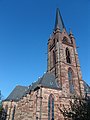 Liebfrauenkirche
 -
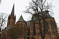 Liebfrauenkirche
 -
 Historic Upper Market
 -
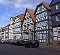 Half-timbered houses
 -
 St. Georgenberg Monastery
 -
 St. Georgenberg Monastery
 -
 Steinhaus, built in 1240
 -
 Mill, built in 1358

-001.jpg)
.JPG)


-002.jpg)

Regular festivals

- "Nightgroove", the pub festival
- Maistadtfest (May Town Festival)
- Pfingstmarkt (Whitsun Market)
With 250.000 visitors the biggest Volksfest in Northern Hesse. - Lichterfest (Light Festival)
- Bütower Treffen (Bütow Meeting)
- Beach-Cup at the Upper Market
- Rolling Oldies
- Herbststadtfest (Autumn Town Festival)
- Halloween-Shopping-Night
- Eder-Bike-Tour
Economy

The economy is divided evenly over various fields, thus contributing to a very good regional labour situation. Established in Frankenberg are, among others, the famous furniture factory of the Brothers Thonet, a plant belonging to the injection moulding firm Hettich and the Bundeswehr's Electronic Warfare Battalion (Bataillon Elektronische Kampfführung) 932. The biggest employer in the area is the heating technology manufacturer Viessmann in Allendorf.
For the last 25 years, one technological focus has been formed by plastics technology. Frankenberg has in Ewikon and Günther two worldwide leaders among companies in so-called hotrunner technology. Likewise important to the economy is Finger Fertighaus, a prefabricated housing company.
Many administrative bodies have their offices in Frankenberg, which was the district seat until 1973.
Since 2005, Frankenberg has been the seat of a professional academy, BA-Nordhessen, which offers systems engineering as its course of study.
Model Hessian Municipality
Since November 2005, Frankenberg has been a "Model Hessian Municipality", the "Family town with future". This ten-year programme sought to choose two midsize towns in Hesse, and Frankenberg was chosen from a field of 33 candidates.
With the "Family town with future" model project, the state of Hesse would like to test whether, and if so with what success, municipal measures can have a positive influence on demographic development. As part of the scientifically conducted experiment, the town gets up to €5,000,000, spread out over the experiment's running time, to carry out the municipal measures in question. The focus of the Frankenberg experiment will be measures aimed at making family life and work life compatible (the so-called work-life balance).
International relations
Twin towns — Sister cities
Frankenberg is twinned with:
|
Persons
- Tyle von Frankenberg, building master and sculptor in stone, (14th century)
- Wigand Gerstenberg, (1457–1522), chronicler, compiled the "Stadtchronik für Frankenberg bis 1525" ("Town chronicle for Frankenberg to 1525")
- Helius Eobanus Hessus (1488-1540), humanist and great Neo-Latin poet
- Conrad Buno (1613-1671), copper cutters, publishers, draftsmen and bookseller
- Philipp Soldan, (1500-1569), sculptor, carver, building master and painter,
- Theodor Valentin Volkmar (1781-1847), legal scientist, mayor in Frankenberg and first mayor of Marburg
- Caspar Garthe, (1795-1874), founder of the Cologne Zoological Garden
- Georg Thonet, (1909-2005), entrepreneur, great-grandson of Michael Thonet, built the Thonet firm back up after the Second World War and won it international fame, especially with Bauhaus steel-pipe furniture.
- Heinrich Kohl (1912-1984), politician (FDP), district administrator of the Frankenberg district and state secretary in the Hessian Ministry of the Interior
- Friedhelm König, (born 1931), Evangelistic writer, spent a great deal of his life in Frankenberg and is cofounder of the Frankenberger Handelsschule.
- Ansgar Nierhoff, (1941-2010), sculptor and artist, grew up in Frankenberg
- Christiane Kohl, (born 1954), journalist (Süddeutsche Zeitung) and writer ("Der Jude und das Mädchen" – "The Jew and the Girl")
References
- ^ "Ergebnisse der jeweils letzten Direktwahl von Landrätinnen und Landräte sowie (Ober-)Bürgermeisterinnen und (Ober-)Bürgermeister in Hessen" (XLS) (in Deutsch). Hessisches Statistisches Landesamt. 21 May 2024.
- ^ "Bevölkerung in Hessen am 31.12.2022 nach Gemeinden" (XLS) (in German). Hessisches Statistisches Landesamt. June 2023.
{{cite web}}: CS1 maint: unrecognized language (link) - ^ "Miasta Partnerskie". Bytów City Council Official Site (in polski). Archived from the original on 2013-05-03. Retrieved 2013-06-22.