Guiscriff
Commune in Brittany, France
Guiscriff (French pronunciation: [ɡiskʁif]; Breton: Gwiskri) is a commune in the Morbihan department in Brittany in north-western France.[2]
Guiscriff
Gwiskri | |
|---|---|
 The parish church in Guiscriff | |
 Guiscriff  Guiscriff | |
| Coordinates: 48°03′02″N 3°38′39″W / 48.0506°N 3.6442°W | |
| Country | France |
| Region | Brittany |
| Department | Morbihan |
| Arrondissement | Pontivy |
| Canton | Gourin |
| Intercommunality | Roi Morvan Communauté |
| Government | |
| • Mayor (2020–2026) | Renée Courtel[1] |
| Area 1 | 85.46 km2 (33.00 sq mi) |
| Time zone | UTC+01:00 (CET) |
| • Summer (DST) | UTC+02:00 (CEST) |
| INSEE/Postal code | 56081 /56560 |
| Elevation | 70–237 m (230–778 ft) |
| 1 French Land Register data, which excludes lakes, ponds, glaciers > 1 km2 (0.386 sq mi or 247 acres) and river estuaries. | |
Population
Inhabitants of Guiscriff are called Guiscrivites. Guiscriff's population peaked at 5,896 in 1921 and declined to 2,081 in 2020. This represents a 65% decrease in total population since the peak census figure.
|
| |||||||||||||||||||||||||||||||||||||||||||||||||||||||||||||||||||||||||||||||||||||||||||||||||||||||||||||||
<graph>{"legends":[],"scales":[{"type":"linear","name":"x","zero":false,"domain":{"data":"chart","field":"x"},"range":"width","nice":true},{"clamp":true,"type":"linear","name":"y","domain":{"data":"chart","field":"y"},"domainMin":0,"zero":false,"range":"height","nice":true},{"domain":{"data":"chart","field":"series"},"type":"ordinal","name":"color","range":"category10"}],"version":2,"marks":[{"type":"line","properties":{"hover":{"stroke":{"value":"red"}},"update":{"stroke":{"scale":"color","field":"series"}},"enter":{"y":{"scale":"y","field":"y"},"x":{"scale":"x","field":"x"},"stroke":{"scale":"color","field":"series"},"strokeWidth":{"value":2.5}}},"from":{"data":"chart"}}],"height":170,"axes":[{"type":"x","title":"Year","scale":"x","format":"d","properties":{"title":{"fill":{"value":"#54595d"}},"grid":{"stroke":{"value":"#54595d"}},"ticks":{"stroke":{"value":"#54595d"}},"axis":{"strokeWidth":{"value":2},"stroke":{"value":"#54595d"}},"labels":{"align":{"value":"right"},"angle":{"value":-45},"fill":{"value":"#54595d"}}},"grid":false},{"type":"y","title":"Population","scale":"y","format":",d","properties":{"title":{"fill":{"value":"#54595d"}},"grid":{"stroke":{"value":"#54595d"}},"ticks":{"stroke":{"value":"#54595d"}},"axis":{"strokeWidth":{"value":2},"stroke":{"value":"#54595d"}},"labels":{"fill":{"value":"#54595d"}}},"grid":true}],"data":[{"format":{"parse":{"y":"integer","x":"integer"},"type":"json"},"name":"chart","values":[{"y":2786,"series":"y","x":1793},{"y":2695,"series":"y","x":1800},{"y":2500,"series":"y","x":1806},{"y":2786,"series":"y","x":1831},{"y":3153,"series":"y","x":1836},{"y":3016,"series":"y","x":1841},{"y":3418,"series":"y","x":1846},{"y":3570,"series":"y","x":1851},{"y":3396,"series":"y","x":1856},{"y":3452,"series":"y","x":1861},{"y":3531,"series":"y","x":1866},{"y":3558,"series":"y","x":1872},{"y":3724,"series":"y","x":1876},{"y":3754,"series":"y","x":1881},{"y":3894,"series":"y","x":1886},{"y":4330,"series":"y","x":1891},{"y":4594,"series":"y","x":1896},{"y":4060,"series":"y","x":1901},{"y":4972,"series":"y","x":1906},{"y":5380,"series":"y","x":1911},{"y":5896,"series":"y","x":1921},{"y":5525,"series":"y","x":1926},{"y":5182,"series":"y","x":1931},{"y":5063,"series":"y","x":1936},{"y":5034,"series":"y","x":1946},{"y":4222,"series":"y","x":1954},{"y":3740,"series":"y","x":1962},{"y":3377,"series":"y","x":1968},{"y":2931,"series":"y","x":1975},{"y":2734,"series":"y","x":1982},{"y":2529,"series":"y","x":1990},{"y":2394,"series":"y","x":1999},{"y":2339,"series":"y","x":2009},{"y":2228,"series":"y","x":2014},{"y":2081,"series":"y","x":2020}]}],"width":340}</graph> | ||||||||||||||||||||||||||||||||||||||||||||||||||||||||||||||||||||||||||||||||||||||||||||||||||||||||||||||||
| Source: EHESS[3] and INSEE (2009–2020)[4] | ||||||||||||||||||||||||||||||||||||||||||||||||||||||||||||||||||||||||||||||||||||||||||||||||||||||||||||||||
Geography
Historically, the village belongs to Cornouaille. The village centre is located 21 km (13 mi) north of Quimperlé and 35 km (22 mi) east of Quimper.
History

Gallery
Church and chapels
-
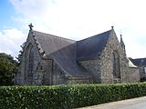
 The parish church
 -
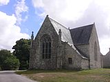
 Chapel Saint Maudé
 -
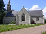
 Chapel Saint Eloi
 -
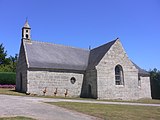
 Chapel Saint Antoine
 -
 Chapel Saint Tugdual


See also
References
- ^ "Maires du Morbihan" (PDF). Préfecture du Morbihan. 7 July 2020.
- ^ Commune de Guiscriff (56081), INSEE
- ^ Des villages de Cassini aux communes d'aujourd'hui: Commune data sheet Guiscriff, EHESS (in French).
- ^ Population en historique depuis 1968, INSEE
External links
Wikimedia Commons has media related to Guiscriff.
- Base Mérimée: Search for heritage in the commune, Ministère français de la Culture. (in French)
- Mayors of Morbihan Association (in French)
This Morbihan geographical article is a stub. You can help Wikipedia by expanding it. |