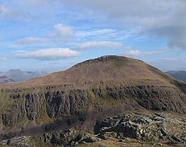
Ruadh Stac Mor
Ruadh Stac Mor or Ruadh-Stac Mòr (Gaelic)[2] is a mountain with a height of 919 metres (3,015 ft) in the Northwest Highlands of Scotland. It is located in the Dundonnell and Fisherfield Forest in Wester Ross.
| Ruadh Stac Mor | |
|---|---|
| An Ruadh-Stac Mòr | |
 | |
<mapframe zoom="10" frameless="1" align="center" longitude="-5.3292" latitude="57.7268" height="200" width="250">{"type":"Feature","geometry":{"coordinates":[-5.3292,57.7268],"type":"Point"},"properties":{"marker-color":"#5E74F3","title":"Ruadh Stac Mor","marker-symbol":"mountain"}}</mapframe> <mapframe zoom="5" frameless="1" align="center" longitude="-5.3292" latitude="57.7268" height="200" width="250">{"type":"Feature","geometry":{"coordinates":[-5.3292,57.7268],"type":"Point"},"properties":{"marker-color":"#5E74F3","title":"Ruadh Stac Mor","marker-symbol":"mountain"}}</mapframe> <mapframe zoom="1" frameless="1" align="center" longitude="-5.3292" latitude="57.7268" height="200" width="250">{"type":"Feature","geometry":{"coordinates":[-5.3292,57.7268],"type":"Point"},"properties":{"marker-color":"#5E74F3","title":"Ruadh Stac Mor","marker-symbol":"mountain"}}</mapframe> | |
| Highest point | |
| Elevation | 919 m (3,015 ft)[1] |
| Prominence | 167 m (548 ft) |
| Listing | Munro, Marilyn |
| Coordinates | 57°43′36″N 5°19′45″W / 57.7268°N 5.3292°W |
| Naming | |
| English translation | great red stack |
| Language of name | Scottish Gaelic |
| Geography | |
| Location | Wester Ross, Scotland |
| Parent range | Northwest Highlands |
| OS grid | NH018756 |
| Topo map | OS Landranger 19 |
One of the remotest Munros in Scotland, it provides superb views from its summit. Climbs generally start from the village of Poolewe to the west.[3]
References
- ^ "Ruadh Stac Mor". hill-bagging.co.uk. Retrieved 31 May 2019.
- ^ "Ruadh Stac Mor". Ainmean-Àite na h-Alba: Gaelic Place-Names of Scotland.
- ^ "walkhighlands Ruadh Stac Mor". walkhighlands.co.uk. Retrieved 31 May 2019.