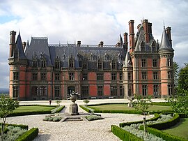
Saint-Goazec
Commune in Brittany, France
Saint-Goazec (French pronunciation: [sɛ̃ ɡwazɛk]; Breton: Sant-Wazeg) in commune in the Finistère department of Brittany in northwestern France.
Saint-Goazec
Sant-Wazeg | |
|---|---|
 | |
| Coordinates: 48°09′52″N 3°46′51″W / 48.1644°N 3.7808°W | |
| Country | France |
| Region | Brittany |
| Department | Finistère |
| Arrondissement | Châteaulin |
| Canton | Briec |
| Intercommunality | Haute Cornouaille |
| Government | |
| • Mayor (2020–2026) | Stéphane Guillou[1] |
| Area 1 | 33.76 km2 (13.03 sq mi) |
| Time zone | UTC+01:00 (CET) |
| • Summer (DST) | UTC+02:00 (CEST) |
| INSEE/Postal code | 29249 /29520 |
| Elevation | 33–295 m (108–968 ft) |
| 1 French Land Register data, which excludes lakes, ponds, glaciers > 1 km2 (0.386 sq mi or 247 acres) and river estuaries. | |
Population
Inhabitants of Saint-Goazec are called in French Saint-Goaziens. The commune's population peaks in 1906.
|
| ||||||||||||||||||||||||||||||||||||||||||||||||||||||||||||||||||||||||||||||||||||||||||||||||||||||||||||||||||
<graph>{"legends":[],"scales":[{"type":"linear","name":"x","zero":false,"domain":{"data":"chart","field":"x"},"range":"width","nice":true},{"clamp":true,"type":"linear","name":"y","domain":{"data":"chart","field":"y"},"domainMin":0,"zero":false,"range":"height","nice":true},{"domain":{"data":"chart","field":"series"},"type":"ordinal","name":"color","range":"category10"}],"version":2,"marks":[{"type":"line","properties":{"hover":{"stroke":{"value":"red"}},"update":{"stroke":{"scale":"color","field":"series"}},"enter":{"y":{"scale":"y","field":"y"},"x":{"scale":"x","field":"x"},"stroke":{"scale":"color","field":"series"},"strokeWidth":{"value":2.5}}},"from":{"data":"chart"}}],"height":170,"axes":[{"type":"x","title":"Year","scale":"x","format":"d","properties":{"title":{"fill":{"value":"#54595d"}},"grid":{"stroke":{"value":"#54595d"}},"ticks":{"stroke":{"value":"#54595d"}},"axis":{"strokeWidth":{"value":2},"stroke":{"value":"#54595d"}},"labels":{"align":{"value":"right"},"angle":{"value":-45},"fill":{"value":"#54595d"}}},"grid":false},{"type":"y","title":"Population","scale":"y","format":",d","properties":{"title":{"fill":{"value":"#54595d"}},"grid":{"stroke":{"value":"#54595d"}},"ticks":{"stroke":{"value":"#54595d"}},"axis":{"strokeWidth":{"value":2},"stroke":{"value":"#54595d"}},"labels":{"fill":{"value":"#54595d"}}},"grid":true}],"data":[{"format":{"parse":{"y":"integer","x":"integer"},"type":"json"},"name":"chart","values":[{"y":1075,"series":"y","x":1793},{"y":898,"series":"y","x":1800},{"y":986,"series":"y","x":1806},{"y":815,"series":"y","x":1821},{"y":1104,"series":"y","x":1831},{"y":1135,"series":"y","x":1836},{"y":1104,"series":"y","x":1841},{"y":1121,"series":"y","x":1846},{"y":1105,"series":"y","x":1851},{"y":1053,"series":"y","x":1856},{"y":1099,"series":"y","x":1861},{"y":1230,"series":"y","x":1866},{"y":1201,"series":"y","x":1872},{"y":1307,"series":"y","x":1876},{"y":1362,"series":"y","x":1881},{"y":1420,"series":"y","x":1886},{"y":1480,"series":"y","x":1891},{"y":1555,"series":"y","x":1896},{"y":1740,"series":"y","x":1901},{"y":1860,"series":"y","x":1906},{"y":1774,"series":"y","x":1911},{"y":1605,"series":"y","x":1921},{"y":1569,"series":"y","x":1926},{"y":1562,"series":"y","x":1931},{"y":1439,"series":"y","x":1936},{"y":1510,"series":"y","x":1946},{"y":1121,"series":"y","x":1954},{"y":1042,"series":"y","x":1962},{"y":976,"series":"y","x":1968},{"y":845,"series":"y","x":1975},{"y":876,"series":"y","x":1982},{"y":771,"series":"y","x":1990},{"y":725,"series":"y","x":1999},{"y":705,"series":"y","x":2007},{"y":713,"series":"y","x":2012},{"y":712,"series":"y","x":2019}]}],"width":340}</graph> | |||||||||||||||||||||||||||||||||||||||||||||||||||||||||||||||||||||||||||||||||||||||||||||||||||||||||||||||||||
| Source: EHESS[2] and INSEE (1968-2017)[3] | |||||||||||||||||||||||||||||||||||||||||||||||||||||||||||||||||||||||||||||||||||||||||||||||||||||||||||||||||||
Geography
Saint-Goazec lies on the northern slope of the Montagnes Noires (french, Black Mountains). The canal de Nantes à Brest, which is the canalized river Aulne, forms the commune's northern border.
Map
See also
References
- ^ "Répertoire national des élus: les maires". data.gouv.fr, Plateforme ouverte des données publiques françaises (in français). 9 August 2021.
- ^ Des villages de Cassini aux communes d'aujourd'hui: Commune data sheet Saint-Goazec, EHESS (in French).
- ^ Population en historique depuis 1968, INSEE
External links
Wikimedia Commons has media related to Saint-Goazec.
- Official website (in French)
- Base Mérimée: Search for heritage in the commune, Ministère français de la Culture. (in French)
- Mayors of Finistère Association (in French)

