Tagewaldhorn
Mountain in Italy
The Tagewaldhorn (Italian: Corno di Tramin; ‹See Tfd›German: Tagewaldhorn) is a mountain in the Sarntal Alps in South Tyrol, Italy.
| Tagewaldhorn | |
|---|---|
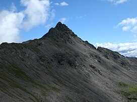
 The Tagewaldhorn (2.708 m) from SE above the innermost Flagger valley, Sarntal Alps, South Tyrol. | |
<mapframe zoom="10" frameless="1" align="center" longitude="11.496944444444" latitude="46.780555555556" height="200" width="250">{"type":"Feature","geometry":{"coordinates":[11.496944444444443,46.78055555555555],"type":"Point"},"properties":{"marker-color":"#5E74F3","title":"Tagewaldhorn","marker-symbol":"mountain"}}</mapframe> <mapframe zoom="5" frameless="1" align="center" longitude="11.496944444444" latitude="46.780555555556" height="200" width="250">{"type":"Feature","geometry":{"coordinates":[11.496944444444443,46.78055555555555],"type":"Point"},"properties":{"marker-color":"#5E74F3","title":"Tagewaldhorn","marker-symbol":"mountain"}}</mapframe> <mapframe zoom="1" frameless="1" align="center" longitude="11.496944444444" latitude="46.780555555556" height="200" width="250">{"type":"Feature","geometry":{"coordinates":[11.496944444444443,46.78055555555555],"type":"Point"},"properties":{"marker-color":"#5E74F3","title":"Tagewaldhorn","marker-symbol":"mountain"}}</mapframe> | |
| Highest point | |
| Elevation | 2,708 m (8,885 ft) |
| Coordinates | 46°46′50″N 11°29′49″E / 46.78056°N 11.49694°E |
| Geography | |
| Location | South Tyrol, Italy |
| Parent range | Sarntal Alps |
| Climbing | |
| First ascent | 12 July 1885 by Julius Pock |
References
- Hanspaul Menara: Südtiroler Gipfelwanderungen. Athesia, Bozen 2001, ISBN 88-8266-013-3
- 88-8315-054-6
- Topografische Wanderkarte, Monti Sarenti / Sarntaler Alpen, Blatt 040, 1:25.000, Casa Editrice Tobacco, ISBN 88-8315-054-6