Template:OSM Location map/examples
numbered dots with an auto-caption
User:RobinLeicester/sandbox/swithlandwood
User:RobinLeicester/sandbox/swithlandwood
[
{"type": "FeatureCollection",
"features": [
{ "type": "Feature",
  "properties": {
   "title": "Kaiwha",
   "description": " -38.50990,175.69186",
   "marker-symbol": "-number-F387175858933850990", "marker-size": "medium", "marker-color": "#105396" },
  "geometry": {"type": "Point", "coordinates": [175.69186,-38.50990] }
}
, { "type": "Feature",
  "properties": {
   "title": "Waihaha",
   "description": " -38.762649,175.685639",
   "marker-symbol": "-number-F387175858933850990", "marker-size": "medium", "marker-color": "#105396" },
  "geometry": {"type": "Point", "coordinates": [175.685639,-38.762649] }
}
, { "type": "Feature",
  "properties": {
   "title": "Motutere",
   "description": " -38.88643,175.95359",
   "marker-symbol": "-number-F387175858933850990", "marker-size": "medium", "marker-color": "#105396" },
  "geometry": {"type": "Point", "coordinates": [175.95359,-38.88643] }
}
, { "type": "Feature",
  "properties": {
   "title": "Pūkawa",
   "description": " -38.9167,175.755",
   "marker-symbol": "-number-F387175858933850990", "marker-size": "medium", "marker-color": "#105396" },
  "geometry": {"type": "Point", "coordinates": [175.755,-38.9167] }
}
, { "type": "Feature",
  "properties": {
   "title": "Rangitoto Range",
   "description": " -38.417,175.583",
   "marker-symbol": "-number-F387175858933850990", "marker-size": "medium", "marker-color": "#105396" },
  "geometry": {"type": "Point", "coordinates": [175.583,-38.417] }
}
, { "type": "Feature",
  "properties": {
   "title": "Tuaropakai (Mōkai)",
   "description": " -38.526348,175.903913",
   "marker-symbol": "-number-F387175858933850990", "marker-size": "medium", "marker-color": "#105396" },
  "geometry": {"type": "Point", "coordinates": [175.903913,-38.526348] }
}
, { "type": "Feature",
  "properties": {
   "title": "Waitahanui pa",
   "description": " -38.944333,175.781431",
   "marker-symbol": "-number-F387175858933850990", "marker-size": "medium", "marker-color": "#105396" },
  "geometry": {"type": "Point", "coordinates": [175.781431,-38.944333] }
}
, { "type": "Feature",
  "properties": {
   "title": "Motuoapa",
   "description": " -38.92148,175.86236",
   "marker-symbol": "-number-F387175858933850990", "marker-size": "medium", "marker-color": "#105396" },
  "geometry": {"type": "Point", "coordinates": [175.86236,-38.92148] }
}
]
}
<syntaxhighlight lang="wikitext"> | minimap = file bottom right | mini-file = New Zealand North Island relief map.jpg | mini-width = 65 |mini-height = 88 | minipog-gx = 54 | minipog-gy = 59 | minimap-boxwidth = 13
| mark-coord1= 38°30′36″S 175°41′31″E / 38.50990°S 175.69186°E | mark-title1 =Kaiwha | shape1=n-circle | shape-color1=dark blue | shape-outline1=white | mark-size1=16 | mark-coord2 = 38°45′46″S 175°41′08″E / 38.762649°S 175.685639°E | mark-title2 = Waihaha | mark-coord3= 38°53′11″S 175°57′13″E / 38.88643°S 175.95359°E | mark-title3 = Motutere | mark-coord4 = 38°55.0′S 175°45.3′E / 38.9167°S 175.7550°E | mark-title4 = Pūkawa | mark-coord5 = 38°25′S 175°35′E / 38.417°S 175.583°E | mark-title5 = Rangitoto Range | mark-coord6 = 38°31′35″S 175°54′14″E / 38.526348°S 175.903913°E | mark-title6 =Tuaropakai (Mōkai) | mark-coord7 = 38°56′40″S 175°46′53″E / 38.944333°S 175.781431°E | mark-title7 = Waitahanui pa | mark-coord8 = 38°55′17″S 175°51′44″E / 38.92148°S 175.86236°E | mark-title8 = Motuoapa | caption = Places in the life of Herea | auto-caption=10</syntaxhighlight>
A map with a variety of features and a main subject.
User:RobinLeicester/sandbox/swithlandwood
User:RobinLeicester/sandbox/swithlandwood
[
{"type": "FeatureCollection",
"features": [
{ "type": "Feature",
"properties": {
"title": "Pentre Ifan, Pembrokeshire",
"description": "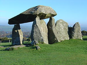 The largest and best preserved neolithic dolmen in Wales 51.9990,-4.77",
"marker-symbol": "-number-F5204830519990520545", "marker-size": "medium", "marker-color": "#AA1205" },
"geometry": {"type": "Point", "coordinates": [-4.77,51.9990] }
}
The largest and best preserved neolithic dolmen in Wales 51.9990,-4.77",
"marker-symbol": "-number-F5204830519990520545", "marker-size": "medium", "marker-color": "#AA1205" },
"geometry": {"type": "Point", "coordinates": [-4.77,51.9990] }
}

, { "type": "Feature",
"properties": {
"title": "Llech-y-Tribedd, Pembrokeshire",
"description": " Llech-y-Tribedd is a well preserved dolmen with three tapering uprights and a massive capstone. 52.0545,-4.7717",
"marker-symbol": "-number-F5204830519990520545", "marker-size": "medium", "marker-color": "#AA1205" },
"geometry": {"type": "Point", "coordinates": [-4.7717,52.0545] }
}
Llech-y-Tribedd is a well preserved dolmen with three tapering uprights and a massive capstone. 52.0545,-4.7717",
"marker-symbol": "-number-F5204830519990520545", "marker-size": "medium", "marker-color": "#AA1205" },
"geometry": {"type": "Point", "coordinates": [-4.7717,52.0545] }
}

, { "type": "Feature",
"properties": {
"title": "Carreg Coetan Arthur, Pembrokeshire",
"description": " Carreg Coetan Arthur is a dolmen in a small hedged enclosure on the outskirts of Newport 52.0186,-4.8282",
"marker-symbol": "-number-F5204830519990520545", "marker-size": "medium", "marker-color": "#AAAA88" },
"geometry": {"type": "Point", "coordinates": [-4.8282,52.0186] }
}
Carreg Coetan Arthur is a dolmen in a small hedged enclosure on the outskirts of Newport 52.0186,-4.8282",
"marker-symbol": "-number-F5204830519990520545", "marker-size": "medium", "marker-color": "#AAAA88" },
"geometry": {"type": "Point", "coordinates": [-4.8282,52.0186] }
}

, { "type": "Feature",
"properties": {
"title": "Banc Du Neolithic enclosure, Pembrokeshire",
"description": " Banc Du is a promentary hill with the first confirmed neolithic enclosure in Wales 51.9409,-4.823",
"marker-symbol": "-number-F5204830519990520545", "marker-size": "medium", "marker-color": "#AA1205" },
"geometry": {"type": "Point", "coordinates": [-4.823,51.9409] }
}
Banc Du is a promentary hill with the first confirmed neolithic enclosure in Wales 51.9409,-4.823",
"marker-symbol": "-number-F5204830519990520545", "marker-size": "medium", "marker-color": "#AA1205" },
"geometry": {"type": "Point", "coordinates": [-4.823,51.9409] }
}

, { "type": "Feature",
"properties": {
"title": "Bedd yr Afanc Burial Chamber, Pembrokeshire",
"description": " Bedd yr Afanc is a stone burial chamber below the summit of Mynydd Preseli 51.9775,-4.7563",
"marker-symbol": "-number-F5204830519990520545", "marker-size": "medium", "marker-color": "#AA1205" },
"geometry": {"type": "Point", "coordinates": [-4.7563,51.9775] }
}
Bedd yr Afanc is a stone burial chamber below the summit of Mynydd Preseli 51.9775,-4.7563",
"marker-symbol": "-number-F5204830519990520545", "marker-size": "medium", "marker-color": "#AA1205" },
"geometry": {"type": "Point", "coordinates": [-4.7563,51.9775] }
}

, { "type": "Feature",
  "properties": {
   "title": "Standing Stones, Pembrokeshire",
   "description": "Tafarn-y-Bwlch and Waun Mawn Standing Stones 51.9685,-4.7945",
   "marker-symbol": "-number-F5204830519990520545", "marker-size": "medium", "marker-color": "#AA1205" },
  "geometry": {"type": "Point", "coordinates": [-4.7945,51.9685] }
}
, { "type": "Feature",
"properties": {
"title": "Trellyffaint burial chamber, Pembrokeshire",
"description": " Trellyffaint dolmen, looking northeast. The capstone has collapsed at some point. 52.0478,-4.7982",
"marker-symbol": "-number-F5204830519990520545", "marker-size": "medium", "marker-color": "#AA1205" },
"geometry": {"type": "Point", "coordinates": [-4.7982,52.0478] }
}
Trellyffaint dolmen, looking northeast. The capstone has collapsed at some point. 52.0478,-4.7982",
"marker-symbol": "-number-F5204830519990520545", "marker-size": "medium", "marker-color": "#AA1205" },
"geometry": {"type": "Point", "coordinates": [-4.7982,52.0478] }
}

, { "type": "Feature",
"properties": {
"title": "Cerig-y-Gof chambered tomb, Pembrokeshire",
"description": " A group of five stone-lined chambers, thought to have been originally covered by a single mound. 52.0137,-4.8627",
"marker-symbol": "-number-F5204830519990520545", "marker-size": "medium", "marker-color": "#AA1205" },
"geometry": {"type": "Point", "coordinates": [-4.8627,52.0137] }
}
A group of five stone-lined chambers, thought to have been originally covered by a single mound. 52.0137,-4.8627",
"marker-symbol": "-number-F5204830519990520545", "marker-size": "medium", "marker-color": "#AA1205" },
"geometry": {"type": "Point", "coordinates": [-4.8627,52.0137] }
}

, { "type": "Feature",
"properties": {
"title": "Bedd Arthur, Pembrokeshire",
"description": " Bedd Arthur is an oval banked enclosure set with stones. 51.9597,-4.7223",
"marker-symbol": "-number-F5204830519990520545", "marker-size": "medium", "marker-color": "#AA1205" },
"geometry": {"type": "Point", "coordinates": [-4.7223,51.9597] }
}
Bedd Arthur is an oval banked enclosure set with stones. 51.9597,-4.7223",
"marker-symbol": "-number-F5204830519990520545", "marker-size": "medium", "marker-color": "#AA1205" },
"geometry": {"type": "Point", "coordinates": [-4.7223,51.9597] }
}

]
}
<syntaxhighlight lang="wikitext"> | mark-coord = 51°59′56″N 4°46′12″W / 51.9990°N 4.7700°W | mark-size = 14 | mark-title = Pentre Ifan, Pembrokeshire | mark-image = DMPentreIfanFront.JPG | mark-description = The largest and best preserved neolithic dolmen in Wales | label = Pentre Ifan | label-size = 14,outline,background |label-color = dark grey | label-pos = left,with-line | ldx=-14|ldy=3</syntaxhighlight>
Using new features: live-link markers and a dashed-line feature to mark out a distance
User:RobinLeicester/sandbox/swithlandwood
User:RobinLeicester/sandbox/swithlandwood[
{"type": "FeatureCollection",
"features": [
{ "type": "Feature",
"properties": {
"title": "Land's End",
"description": " The south-western tip of Cornwall 50.06811,-5.71526",
"marker-symbol": "-number-F546318935006811", "marker-size": "medium", "marker-color": "#AA1205" },
"geometry": {"type": "Point", "coordinates": [-5.71526,50.06811] }
}
The south-western tip of Cornwall 50.06811,-5.71526",
"marker-symbol": "-number-F546318935006811", "marker-size": "medium", "marker-color": "#AA1205" },
"geometry": {"type": "Point", "coordinates": [-5.71526,50.06811] }
}

, { "type": "Feature",
"properties": {
"title": "John o' Groats",
"description": " The north-easterly tip of Scotland 58.644115,-3.069552",
"marker-symbol": "-number-F546318935006811", "marker-size": "medium", "marker-color": "#AA1205" },
"geometry": {"type": "Point", "coordinates": [-3.069552,58.644115] }
}
The north-easterly tip of Scotland 58.644115,-3.069552",
"marker-symbol": "-number-F546318935006811", "marker-size": "medium", "marker-color": "#AA1205" },
"geometry": {"type": "Point", "coordinates": [-3.069552,58.644115] }
}

, { "type": "Feature",
  "properties": {
   "title": "",
   "description": " 54.6,-4.305",
   "marker-symbol": "-number-F546318935006811", "marker-size": "medium", "marker-color": "#AA1205" },
  "geometry": {"type": "Point", "coordinates": [-4.305,54.6] }
}
]
}
<syntaxhighlight lang="wikitext">
|mark-coord3=54°36′00″N 4°18′18″W / 54.6°N 4.305°W |mark-size3=350 |shape3=rule |shape-angle3=-80.2 |label-angle3=-80.2 |label-pos3=center |ldy3=-74| ldx3=14 |label3=Direct line distance^^= 603 miles (970 km) |shape-outline3=dark grey,5,40,dotted </syntaxhighlight>
Using the new photo-panel feature to highlight a landmark
[
{"type": "FeatureCollection",
"features": [
{ "type": "Feature",
"properties": {
"title": "National Carillon",
"description": "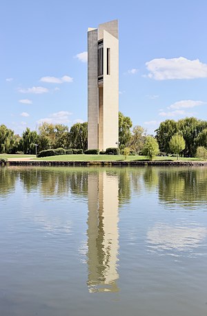 -35.2985,149.1417",
"marker-symbol": "-number-F3529605149122893352985", "marker-size": "medium", "marker-color": "#AA1205" },
"geometry": {"type": "Point", "coordinates": [149.1417,-35.2985] }
}
-35.2985,149.1417",
"marker-symbol": "-number-F3529605149122893352985", "marker-size": "medium", "marker-color": "#AA1205" },
"geometry": {"type": "Point", "coordinates": [149.1417,-35.2985] }
}

]
}
<syntaxhighlight lang="wikitext"> | mark-coord1 = 35°17′55″S 149°08′30″E / 35.2985°S 149.1417°E | label-pos1=left, photo-panel, 0.65, 83 | label-color1=hard blue | ldx1=-36| ldy1=-93 | label1=National ^Carillon | mark-title1=National Carillon | mark-image1=National Carillon, Canberra ACT.jpg </syntaxhighlight>
Using numbered dots, including the new lines features to sort out crowded dots
Country-scale map with live-link locator dots (zoom=5)
Austria
User:RobinLeicester/sandbox/swithlandwood
User:RobinLeicester/sandbox/swithlandwood[
{"type": "FeatureCollection",
"features": [
{ "type": "Feature",
  "properties": {
   "title": "Donauwörth on 7 October 1805",
   "description": " 48.7,10.8",
   "marker-symbol": "-number-F4813893487", "marker-size": "medium", "marker-color": "#5581A9" },
  "geometry": {"type": "Point", "coordinates": [10.8,48.7] }
}
, { "type": "Feature",
  "properties": {
   "title": "Battle of Wertingen on 8 October 1805",
   "description": " 48.56,10.68",
   "marker-symbol": "-number-F4813893487", "marker-size": "medium", "marker-color": "#5581A9" },
  "geometry": {"type": "Point", "coordinates": [10.68,48.56] }
}
, { "type": "Feature",
  "properties": {
   "title": "Battle of Günzburg on 9 October 1805",
   "description": " 48.45,10.27",
   "marker-symbol": "-number-F4813893487", "marker-size": "medium", "marker-color": "#5581A9" },
  "geometry": {"type": "Point", "coordinates": [10.27,48.45] }
}
, { "type": "Feature",
  "properties": {
   "title": "Battle of Haslach-Jungingen on 11 October 1805",
   "description": " 48.4,9.98",
   "marker-symbol": "-number-F4813893487", "marker-size": "medium", "marker-color": "#5581A9" },
  "geometry": {"type": "Point", "coordinates": [9.98,48.4] }
}
, { "type": "Feature",
  "properties": {
   "title": "Battle of Memmingen on 14 October 1805",
   "description": " 47.99,10.18",
   "marker-symbol": "-number-F4813893487", "marker-size": "medium", "marker-color": "#5581A9" },
  "geometry": {"type": "Point", "coordinates": [10.18,47.99] }
}
, { "type": "Feature",
  "properties": {
   "title": "Battle of Elchingen on 14 October 1805",
   "description": " 48.45,10.1",
   "marker-symbol": "-number-F4813893487", "marker-size": "medium", "marker-color": "#5581A9" },
  "geometry": {"type": "Point", "coordinates": [10.1,48.45] }
}
, { "type": "Feature",
  "properties": {
   "title": "Battle of Ulm from 15 to 20 October 1805",
   "description": " 48.38,9.98",
   "marker-symbol": "-number-F4813893487", "marker-size": "medium", "marker-color": "#7A0101" },
  "geometry": {"type": "Point", "coordinates": [9.98,48.38] }
}
, { "type": "Feature",
  "properties": {
   "title": "Battle of Lambach on 31 October 1805",
   "description": " 48.09,13.88",
   "marker-symbol": "-number-F4813893487", "marker-size": "medium", "marker-color": "#5581A9" },
  "geometry": {"type": "Point", "coordinates": [13.88,48.09] }
}
, { "type": "Feature",
  "properties": {
   "title": "Battle of Amstetten on 5 November 1805",
   "description": " 48.12,14.87",
   "marker-symbol": "-number-F4813893487", "marker-size": "medium", "marker-color": "#5581A9" },
  "geometry": {"type": "Point", "coordinates": [14.87,48.12] }
}
, { "type": "Feature",
  "properties": {
   "title": "Battle of Mariazell on 8 November 1805",
   "description": " 47.77,15.32",
   "marker-symbol": "-number-F4813893487", "marker-size": "medium", "marker-color": "#5581A9" },
  "geometry": {"type": "Point", "coordinates": [15.32,47.77] }
}
, { "type": "Feature",
  "properties": {
   "title": "Battle of Dürenstein on 11 November 1805",
   "description": " 48.39,15.52",
   "marker-symbol": "-number-F4813893487", "marker-size": "medium", "marker-color": "#5581A9" },
  "geometry": {"type": "Point", "coordinates": [15.52,48.39] }
}
, { "type": "Feature",
  "properties": {
   "title": "Battle of Schöngrabern on 16 November 1805",
   "description": " 48.61,16.02",
   "marker-symbol": "-number-F4813893487", "marker-size": "medium", "marker-color": "#5581A9" },
  "geometry": {"type": "Point", "coordinates": [16.02,48.61] }
}
, { "type": "Feature",
  "properties": {
   "title": "Battle of Wischau on 25 November 1805",
   "description": " 49.28,17",
   "marker-symbol": "-number-F4813893487", "marker-size": "medium", "marker-color": "#5581A9" },
  "geometry": {"type": "Point", "coordinates": [17,49.28] }
}
, { "type": "Feature",
  "properties": {
   "title": "Battle of Austerlitz on 2 December 1805",
   "description": " 49.13,16.77",
   "marker-symbol": "-number-F4813893487", "marker-size": "medium", "marker-color": "#000000" },
  "geometry": {"type": "Point", "coordinates": [16.77,49.13] }
}
]
}
<syntaxhighlight lang="wikitext">
| label6= | label-pos6=top, n-line | label-size6=12,outline,background | ldx6=-11|ldy6=-18 | mark-coord6=48°27′N 10°06′E / 48.45°N 10.1°E | mark-title6=Battle of Elchingen on 14 October 1805</syntaxhighlight>
Using new shapes and line features to add items relevant to the article
Landscape-scale map with a selection of features. (zoom=14)
{
  "type": "ExternalData",
  "service": "geoline",
  "ids": "Q748078",
  "properties": {
    "stroke": "#000000",
    "stroke-width": 6,
    "stroke-opacity": 0.1
   }
}]</mapframe>User:RobinLeicester/sandbox/swithlandwoodUser:RobinLeicester/sandbox/swithlandwood
User:RobinLeicester/sandbox/swithlandwood[
{
 "type": "ExternalData",
 "service": "geoline",
 "ids": "Q748078",
 "properties": {
   "title": "Neath Port Talbot",
   "description": "",
   "stroke": "#CC3333",
   "stroke-width": 3
 }
 },
{"type": "FeatureCollection",
"features": [
{ "type": "Feature",
  "properties": {
   "title": "Blast Furnaces at Banwen",
   "description": " 51.7811,-3.6425",
   "marker-symbol": "-number-F517838365625178115178365", "marker-size": "medium", "marker-color": "#AA1205" },
  "geometry": {"type": "Point", "coordinates": [-3.6425,51.7811] }
}
, { "type": "Feature",
  "properties": {
   "title": "Roman Auxiliary Fort",
   "description": " 51.78365,-3.6553",
   "marker-symbol": "-number-F517838365625178115178365", "marker-size": "medium", "marker-color": "#FFFFFF" },
  "geometry": {"type": "Point", "coordinates": [-3.6553,51.78365] }
}
, { "type": "Feature",
  "properties": {
   "title": "Roman Marching Camp",
   "description": " 51.7802,-3.6515",
   "marker-symbol": "-number-F517838365625178115178365", "marker-size": "medium", "marker-color": "#FFFFFF" },
  "geometry": {"type": "Point", "coordinates": [-3.6515,51.7802] }
}
, { "type": "Feature",
  "properties": {
   "title": "Henrhyd Waterfall",
   "description": " 51.7943,-3.66327",
   "marker-symbol": "-number-F517838365625178115178365", "marker-size": "medium", "marker-color": "#AA1205" },
  "geometry": {"type": "Point", "coordinates": [-3.66327,51.7943] }
}
, { "type": "Feature",
  "properties": {
   "title": "Memorial Stone to St Patrick",
   "description": " 51.77603,-3.65821",
   "marker-symbol": "-number-F517838365625178115178365", "marker-size": "medium", "marker-color": "#AA1205" },
  "geometry": {"type": "Point", "coordinates": [-3.65821,51.77603] }
}
]
}
<syntaxhighlight lang="wikitext">
| mark-coord1 = 51°47′01″N 3°39′19″W / 51.78365°N 3.6553°W | shape1=box | mark-size1=17,17,3 | shape-outline1=hard grey,1,70 | shape-color1=white | shape-angle1=-9 | label1 = Roman Fort | ldx1=-3 | mark-title1 = Roman Auxiliary Fort | label-pos1=left | label-angle1=0 | label-size1 = 12
...
| mark-coord8 = 51°47′10″N 3°40′00″W / 51.7860°N 3.6667°W | mark-size8=0 | mark-title8 = none | label8=Powys^Neath Port Talbot | label-size8=8 | label-angle8=-1 | label-pos8=center | label-color8=black,40 </syntaxhighlight>
Example from Margam Stones Museum (right) landscape scale locator dots (zoom=12)
User:RobinLeicester/sandbox/swithlandwood
User:RobinLeicester/sandbox/swithlandwood[
{"type": "FeatureCollection",
"features": [
{ "type": "Feature",
  "properties": {
   "title": "Margam Stones Museum",
   "description": " 51.56327,-3.73057",
   "marker-symbol": "-number-F5156737438935156327", "marker-size": "medium", "marker-color": "#5581A9" },
  "geometry": {"type": "Point", "coordinates": [-3.73057,51.56327] }
}
51.56327,-3.73057",
"marker-symbol": "-number-F5156737438935156327", "marker-size": "medium", "marker-color": "#5581A9" },
"geometry": {"type": "Point", "coordinates": [-3.73057,51.56327] }
}
.jpg)
, { "type": "Feature",
  "properties": {
   "title": "Pumpeius Stone (Kenfig)",
   "description": " 51.545,-3.7267",
   "marker-symbol": "-number-F5156737438935156327", "marker-size": "medium", "marker-color": "#5581A9" },
  "geometry": {"type": "Point", "coordinates": [-3.7267,51.545] }
}
, { "type": "Feature",
"properties": {
"title": "Bodvoc Stone",
"description": " Ring cairn, with replica stone. 51.5857,-3.6893",
"marker-symbol": "-number-F5156737438935156327", "marker-size": "medium", "marker-color": "#5581A9" },
"geometry": {"type": "Point", "coordinates": [-3.6893,51.5857] }
}
Ring cairn, with replica stone. 51.5857,-3.6893",
"marker-symbol": "-number-F5156737438935156327", "marker-size": "medium", "marker-color": "#5581A9" },
"geometry": {"type": "Point", "coordinates": [-3.6893,51.5857] }
}

, { "type": "Feature",
  "properties": {
   "title": "Cwrt Uchaf (4, Pillar of Thomas; also 9 and 16)",
   "description": " 51.59127,-3.781297",
   "marker-symbol": "-number-F5156737438935156327", "marker-size": "medium", "marker-color": "#5581A9" },
  "geometry": {"type": "Point", "coordinates": [-3.781297,51.59127] }
}
, { "type": "Feature",
  "properties": {
   "title": "Margam Church and churchyard (5,6,7, 8 and 15)",
   "description": " 51.56258,-3.72989",
   "marker-symbol": "-number-F5156737438935156327", "marker-size": "medium", "marker-color": "#5581A9" },
  "geometry": {"type": "Point", "coordinates": [-3.72989,51.56258] }
}
, { "type": "Feature",
  "properties": {
   "title": "Cwrt-y-defaid (10, 11: Ilci and Ilquici crosses)",
   "description": " 51.55574,-3.7304",
   "marker-symbol": "-number-F5156737438935156327", "marker-size": "medium", "marker-color": "#5581A9" },
  "geometry": {"type": "Point", "coordinates": [-3.7304,51.55574] }
}
, { "type": "Feature",
  "properties": {
   "title": "Port Talbot Railway Station (cross 12)",
   "description": " 51.592,-3.781",
   "marker-symbol": "-number-F5156737438935156327", "marker-size": "medium", "marker-color": "#5581A9" },
  "geometry": {"type": "Point", "coordinates": [-3.781,51.592] }
}
, { "type": "Feature",
  "properties": {
   "title": "Eglwys Nunydd (Cart wheel cross 13)",
   "description": " 51.548633,-3.7278518",
   "marker-symbol": "-number-F5156737438935156327", "marker-size": "medium", "marker-color": "#5581A9" },
  "geometry": {"type": "Point", "coordinates": [-3.7278518,51.548633] }
}
]
}
References
- ^ Royal Commission on the Ancient and Historical Monuments of Wales (1976). Glamorgan Inventory, Vol 1, Part 2: The Iron Age and Roman Occupation. p. 100.
Some pages with example uses for OSM Location map
Roman Britain fortress ground plans, etc
Townscape scale maps to show 'on-the-ground' features (zoom 15/16)
- Caerleon Roman Fortress and Baths
- Isca Augusta (Roman Fortress at Caerleon)
- Burrium (Roman fortress at Usk)
- Nidum (Roman auxilliary fortress at Neath)
- Leucarum (Roman auxilliary fortress at Loughor)
- Banwen (Roman and other sites)
Building-scale architectural plan
(zoom=19) St Illtyd's Church, Llantwit Major