Valframbert
Commune in Normandy, France
Valframbert (French pronunciation: [valfʁɑ̃bɛʁ] ) is a commune in the Orne department in north-western France.
Valframbert | |
|---|---|
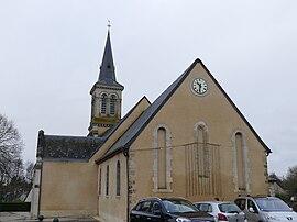
 The church in Valframbert | |
| Coordinates: 48°27′52″N 0°06′32″E / 48.4644°N 0.1089°E | |
| Country | France |
| Region | Normandy |
| Department | Orne |
| Arrondissement | Alençon |
| Canton | Damigny |
| Intercommunality | CU d'Alençon |
| Government | |
| • Mayor (2020–2026) | Francis Aïvar[1] |
| Area 1 | 13.95 km2 (5.39 sq mi) |
| Time zone | UTC+01:00 (CET) |
| • Summer (DST) | UTC+02:00 (CEST) |
| INSEE/Postal code | 61497 /61250 |
| Elevation | 133–179 m (436–587 ft) (avg. 147 m or 482 ft) |
| 1 French Land Register data, which excludes lakes, ponds, glaciers > 1 km2 (0.386 sq mi or 247 acres) and river estuaries. | |
Geography
The commune along with another 32 communes is part of a 3,503 hectare, Natura 2000 conservation area, called the Haute vallée de la Sarthe.[2]
Points of interest
National heritage sites
- Château d'Aché a nineteenth century chateau, it was registered as a Monument historique in 1994.[3]
Transport
- Aérodrome d'Alençon - Valframbert is an Aerodrome within the commune which is also shared with neighbouring communes of Cerisé and Alençon that opened in 1936.[4][5] Its IATA airport code is XAN and its ICAO airport code is LFOF.[6]
See also
References
- ^ "Répertoire national des élus: les maires". data.gouv.fr, Plateforme ouverte des données publiques françaises (in français). 2 December 2020.
- ^ "INPN - FSD Natura 2000 - FR2500107 - Haute Vallée de la Sarthe - Description".
- ^ "Château d'Aché à Valframbert - PA00132906". monumentum.fr.
- ^ "Histoire. Alençon a-t-elle raté le train de l'aviation ?". actu.fr. 1 June 2021.
- ^ "Google Maps". Google Maps.
- ^ "Alençon Valframbert - France". World Airport Codes.
Wikimedia Commons has media related to Valframbert.

