Albigna lake
| Albigna lake | |
|---|---|
| Lägh da l'Albigna Lago da l'Albigna | |
 | |
 | |
| Location | Bregaglia, Graubünden |
| Coordinates | 46°19′48″N 9°38′51″E / 46.33000°N 9.64750°E |
| Type | reservoir |
| Primary inflows | mountain streams |
| Primary outflows | Albigna |
| Catchment area | 20.5 km2 (7.9 sq mi) |
| Basin countries | Switzerland |
| Surface area | 1.13 km2 (0.44 sq mi) |
| Max. depth | 108 m (354 ft) |
| Surface elevation | 2,163 m (7,096 ft) |
| Lua error in Module:Mapframe at line 384: attempt to perform arithmetic on local 'lat_d' (a nil value). | |
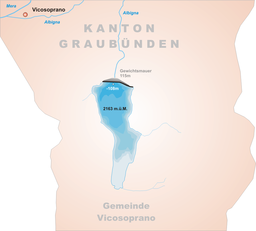
Albigna Lake (German: Albignasee, Italian: Lago da l'Albigna, Romansh: Lägh da l'Albigna) is a reservoir in the canton of Graubünden, Switzerland. It is located in the municipality of Vicosoprano at an elevation of 2,163 metres (7,096 ft) on the southwest side of the Bregaglia valley, northeast of Pizzo Cacciabella. The lake has a surface area of 1.13 square kilometres (280 acres). Its outflow, the Albigna River, is a left tributary of the Mera River.
See also
External links
 Media related to Albigna lake at Wikimedia Commons
Categories:
- Short description with empty Wikidata description
- Coordinates not on Wikidata
- Articles using infobox body of water without alt
- Articles using infobox body of water without pushpin map alt
- Articles using infobox body of water without alt bathymetry
- Commons category link is defined as the pagename
- Reservoirs in Switzerland
- Lakes of Graubünden
- Val Bregaglia
- Graubünden lake stubs


