Audenge
Audenge | |
|---|---|
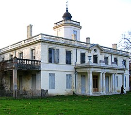
 Chateau of Certes | |
| Coordinates: 44°41′05″N 1°00′43″W / 44.6847°N 1.0119°W | |
| Country | France |
| Region | Nouvelle-Aquitaine |
| Department | Gironde |
| Arrondissement | Arcachon |
| Canton | Andernos-les-Bains |
| Intercommunality | CA Bassin d'Arcachon Nord |
| Government | |
| • Mayor (2020–2026) | Nathalie Le Yondre[1] |
| Area 1 | 82.09 km2 (31.70 sq mi) |
| Time zone | UTC+01:00 (CET) |
| • Summer (DST) | UTC+02:00 (CEST) |
| INSEE/Postal code | 33019 /33980 |
| Elevation | 0–59 m (0–194 ft) (avg. 7 m or 23 ft) |
| 1 French Land Register data, which excludes lakes, ponds, glaciers > 1 km2 (0.386 sq mi or 247 acres) and river estuaries. | |
Audenge (French pronunciation: [odɑ̃ʒ]; Occitan: Audenja) is a commune in the Gironde department in southwestern France.
Geography
The town is situated on the Arcachon Bay (Bassin d'Arcachon), between Lanton, Biganos and Marcheprime.
Population
Inhabitants of Audenge are called Audengeois.
| Year | Pop. | ±% p.a. |
|---|---|---|
| 1968 | 2,234 | — |
| 1975 | 2,529 | +1.79% |
| 1982 | 2,675 | +0.81% |
| 1990 | 2,981 | +1.36% |
| 1999 | 3,948 | +3.17% |
| 2007 | 5,660 | +4.61% |
| 2012 | 6,622 | +3.19% |
| 2017 | 7,993 | +3.84% |
| Source: INSEE[2] | ||
History
Audenge's patron saint is Saint Yves, patron of fishermen.
See also
References
- ^ "Répertoire national des élus: les maires". data.gouv.fr, Plateforme ouverte des données publiques françaises (in français). 2 December 2020.
- ^ Population en historique depuis 1968, INSEE
Wikimedia Commons has media related to Audenge.
Categories:
- CS1 français-language sources (fr)
- Use dmy dates from August 2023
- Articles with invalid date parameter in template
- Short description with empty Wikidata description
- Coordinates not on Wikidata
- Pages with French IPA
- Articles containing Occitan (post 1500)-language text
- Pages using Lang-xx templates
- Commons category link is defined as the pagename
- Communes of Gironde
- Gironde geography stubs


