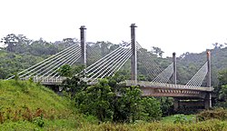
Brazil–Peru Integration Bridge
Brazil-Peru Integration Bridge | |
|---|---|
 | |
| Coordinates | 10°56′29″S 69°34′37″W / 10.94139°S 69.57694°W |
| Crosses | Acre River |
| Locale | Border between Peru and Brazil near Iñapari |
| Characteristics | |
| Total length | 240 metres (790 ft) |
| Longest span | 110 metres (360 ft) |
| History | |
| Opened | 2006 |
| Location | |
| <mapframe zoom="10" frameless="1" align="center" longitude="-69.576944444444" latitude="-10.941388888889" height="200" width="250">{"type":"Feature","geometry":{"coordinates":[-69.57694444444444,-10.94138888888889],"type":"Point"},"properties":{"marker-color":"#5E74F3","title":"Brazil–Peru Integration Bridge","marker-symbol":"bridge"}}</mapframe> | |
The Brazil-Peru Integration Bridge is a bridge that crosses the Acre River at a point which forms the international border between Peru and Brazil. The bridge is part of highway BR-317, and connects the Peruvian city Iñapari to the Brazilian city Assis Brasil. The bridge is very close to the Bolivian city Bolpebra.

Gallery


