
Chablais Alps
| Chablais Alps | |
|---|---|
| French: Préalpes franco-suisses | |
 The seven summits of the Dents du Midi | |
| Highest point | |
| Peak | Dents du Midi (Haute Cime) |
| Elevation | 3,257 m (10,686 ft) |
| Coordinates | 46°9′45″N 6°55′25″E / 46.16250°N 6.92361°E |
| Geography | |
Location of the main peaks <mapframe width="280" height="450" zoom="10" longitude="6.8" latitude="46.2" mapstyle="osm-intl" frameless="true">[
]</mapframe>
5km 3miles
France
Switzerland
Tenneverge (2,989)
Hauts forts (2,466)
Mont Buet (3,096)
Dents blanches (2,756)
Mont de Grange (2,432)
Cornettes de Bise (2,432)
Dent d'Oche (2,221)
Les Jumelles
(2,215)
Tour Salière
(3,220)
Dents du Midi (3,257) <maplink zoom="10" class="no-icon" frameless="1" latitude="46.2" longitude="6.8" text="'"`UNIQ--templatestyles-0000000E-QINU`"'<span class="rt-commentedText tooltip tooltip-dotted " title="'"`UNIQ--nowiki-00000010-QINU`"'"> </span>">
[
{"type": "FeatureCollection", "features": [
  "properties": {
   "title": ".",
   "description": " 46.1606,6.9235",
   "marker-symbol": "-number-F462683461606", "marker-size": "medium", "marker-color": "#AA1205" },
  "geometry": {"type": "Point", "coordinates": [6.9235,46.1606] }
}
, { "type": "Feature", "properties": {
"title": "",
"description": " 46.1268,6.9247",
"marker-symbol": "-number-F462683461606", "marker-size": "medium", "marker-color": "#AA1205" },
"geometry": {"type": "Point", "coordinates": [6.9247,46.1268] }
}
, { "type": "Feature", "properties": {
"title": "",
"description": " 46.3517,6.8155",
"marker-symbol": "-number-F462683461606", "marker-size": "medium", "marker-color": "#AA1205" },
"geometry": {"type": "Point", "coordinates": [6.8155,46.3517] }
}
, { "type": "Feature", "properties": {
"title": "",
"description": " 46.3528,6.7313",
"marker-symbol": "-number-F462683461606", "marker-size": "medium", "marker-color": "#AA1205" },
"geometry": {"type": "Point", "coordinates": [6.7313,46.3528] }
}
, { "type": "Feature", "properties": {
"title": "",
"description": " 46.3325,6.7847",
"marker-symbol": "-number-F462683461606", "marker-size": "medium", "marker-color": "#AA1205" },
"geometry": {"type": "Point", "coordinates": [6.7847,46.3325] }
}
, { "type": "Feature", "properties": {
"title": "",
"description": " 46.2625,6.7806",
"marker-symbol": "-number-F462683461606", "marker-size": "medium", "marker-color": "#AA1205" },
"geometry": {"type": "Point", "coordinates": [6.7806,46.2625] }
}
, { "type": "Feature", "properties": {
"title": "",
"description": " 46.1319,6.8420",
"marker-symbol": "-number-F462683461606", "marker-size": "medium", "marker-color": "#AA1205" },
"geometry": {"type": "Point", "coordinates": [6.8420,46.1319] }
}
, { "type": "Feature", "properties": {
"title": "",
"description": " 46.02475,6.8526",
"marker-symbol": "-number-F462683461606", "marker-size": "medium", "marker-color": "#AA1205" },
"geometry": {"type": "Point", "coordinates": [6.8526,46.02475] }
}
, { "type": "Feature", "properties": {
"title": "",
"description": " 46.1679,6.7777",
"marker-symbol": "-number-F462683461606", "marker-size": "medium", "marker-color": "#AA1205" },
"geometry": {"type": "Point", "coordinates": [6.7777,46.1679] }
}
, { "type": "Feature", "properties": {
"title": "",
"description": " 46.0938,6.8793",
"marker-symbol": "-number-F462683461606", "marker-size": "medium", "marker-color": "#AA1205" },
"geometry": {"type": "Point", "coordinates": [6.8793,46.0938] }
}
, { "type": "Feature", "properties": {
"title": "",
"description": " 46.26,6.915",
"marker-symbol": "-number-F462683461606", "marker-size": "medium", "marker-color": "#AA1205" },
"geometry": {"type": "Point", "coordinates": [6.915,46.26] }
}
, { "type": "Feature", "properties": {
"title": "",
"description": " 46.1817,6.6934",
"marker-symbol": "-number-F462683461606", "marker-size": "medium", "marker-color": "#AA1205" },
"geometry": {"type": "Point", "coordinates": [6.6934,46.1817] }
}
| |
| Countries | Switzerland and France |
| Departments | Valais and Haute Savoie |
| Parent range | Alps |
| Borders on | Bernese Alps and Mont Blanc Massif |
The Chablais Alps (French: Massif du Chablais, pronounced [masif dy ʃablɛ]) are a mountain range in the Western Alps. They are situated between Lake Geneva and the Mont Blanc Massif.[1] The Col des Montets separates them from the Mont Blanc Massif in the south, and the Rhône valley separates them from the Bernese Alps in the east.
The Chablais Alps are composed of two distinct parts separated by the Val d'Illiez: the Dents du Midi massif on the south which contains the highest peaks, and the alpine foothills on the north.
Peaks
The peaks of the Chablais Alps include:
| Peak | Elevation (m/ft) | |
|---|---|---|
| Dents du Midi | 3,257 | 10,686 |
| Tour Sallière | 3,220 | 10,564 |
| Mont Ruan | 3,053 | 10,016 |
| Le Luisin | 2,786 | 9,140 |
| Dents Blanches | 2,759 | 9,052 |
| Pointe d'Anterne | 2,733 | 8,967 |
| Fontanabran | 2,703 | 8,868 |
| Hauts-Forts | 2,466 | 8,091 |
| Cornettes de Bise | 2,432 | 7,979 |
| Les Jumelles | 2,215 | 7,267 |
| Le Grammont | 2,172 | 7,126 |
| Pointe de l'Au | 2,152 | 7,060 |
| Dent du Vélan | 2,059 | 6,755 |
| Pointe de Bellevue | 2,042 | 6,699 |
| Pointe de Nyon | 2,019 | 6,624 |
| Pointe de Chavasse | 2,012 | 6,601 |
| Pointe d'Uble | 1,963 | 6,440 |
| Mont Billiat | 1,894 | 6,214 |
| Pointe d'Ireuse | 1,890 | 6,200 |
| Mont Ouzon | 1,880 | 6,170 |
| Le Môle | 1,863 | 6,112 |
| Grenier de Commune | 1,775 | 5,823 |
| Montagne des Mémises | 1,674 | 5,492 |
| Pointe de Miribel | 1,581 | 5,187 |
| Pointe des Brasses | 1,502 | 4,928 |
| Mont Bichet | 1,360 | 4,460 |
| Mont Orchez | 1,347 | 4,419 |
| Mont de Boisy | 739 | 2,425 |
-
 The Rhône valley on the right and the east part of the Chablais Alps on the left from across Lake Geneva
 -
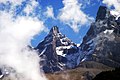 Summits of the Dents du Midi
 -
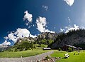 Above Champéry
 -
 Tour Sallière
 -


See also
References
- ^ Chaîne franco-suisse, Club Alpin Suisse CAS, 2003, ISBN -978-3-85902-209-6
- Short description with empty Wikidata description
- Articles containing French-language text
- Pages using Lang-xx templates
- Coordinates not on Wikidata
- Articles containing OSM location maps
- Pages with French IPA
- Mountain ranges of the Alps
- Mountain ranges of Switzerland
- Mountain ranges of Auvergne-Rhône-Alpes
- Mountains of Valais
- Swiss Alps