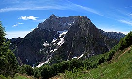
Col Nudo
| Col Nudo | |
|---|---|
 Col Nudo northern slopes | |
| Highest point | |
| Elevation | 2,471 m (8,107 ft)[1] |
| Prominence | 1,645 m (5,397 ft)[2][3] |
| Listing | |
| Coordinates | 46°13′44″N 12°24′05″E / 46.22889°N 12.40139°E |
| Geography | |
| Country | Italy |
| Regions | Veneto and Friuli-Venezia Giulia |
| Parent range | Venetian Prealps |
The Col Nudo is a mountain in the Alps located in Italy. It is the highest peak of the Venetian Prealps and the 30th most prominent summit of the Alps.
Geography
Administratively the mountain is divided between the Italian regions of Friuli-Venezia Giulia (province of Pordenone) and Veneto (province of Belluno).
SOIUSA classification
According to SOIUSA (International Standardized Mountain Subdivision of the Alps) the mountain can be classified in the following way:[4]
- main part = Eastern Alps
- major sector = Central Eastern Alps
- section = Venetian Prealps
- subsection = Prealpi Bellunesi
- supergroup = Catena Cavallo-Visentin
- group = Gruppo Col Nudo-Cavallo
- subgroup = Sottogruppo del Col Nudo
- code = II/C-32.II-B.2.a
References
- ^ "Topographic map of Col Nudo". opentopomap.org. Retrieved 2023-07-03.
- ^ "Col Nudo, Italy". Peakbagger.com. Retrieved 2023-07-03.
- ^ Key col:Passo di San Osvaldo - 827 m
- ^ Marazzi, Sergio (2005). Atlante Orografico delle Alpi. SOIUSA (in Italian). Priuli & Verlucca. p. 294. ISBN 978-88-8068-273-8.
{{cite book}}: CS1 maint: unrecognized language (link)
External links
- Photo of Col Nudo on www.summitpost.org
