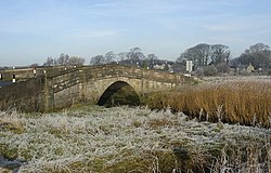
Conder Bridge
Conder Bridge | |
|---|---|
 The bridge in 2008, looking northwest | |
| Coordinates | 53°59′42″N 2°49′33″W / 53.994863°N 2.82580797°W |
| Carries | A588 |
| Crosses | River Conder |
| Locale | Conder Green, Thurnham, Lancashire, England |
| History | |
| Opened | Early 19th century |
| Location | |
| <mapframe zoom="10" frameless="1" align="center" longitude="-2.82580797" latitude="53.994863" height="200" width="250">{"type":"Feature","geometry":{"coordinates":[-2.82580797,53.994863],"type":"Point"},"properties":{"marker-color":"#5E74F3","title":"Conder Bridge","marker-symbol":"bridge"}}</mapframe> | |
Conder Bridge is a Grade II listed single segmental arch bridge spanning the River Conder in the English village of Conder Green, Thurnham, Lancashire. The structure dates to the early 19th century.[1] The bridge carries the vehicular and pedestrian traffic of the A588.
The bridge is flanked by piers, with abutments also punctuated by piers. It has a solid parapet with a string course and weathered coping.[1]
See also
References
- ^ 1.0 1.1 "Conder Bridge". Historic England. Retrieved 15 November 2021.
Categories:
- Short description with empty Wikidata description
- Use dmy dates from November 2021
- Use British English from November 2021
- Coordinates not on Wikidata
- Infobox mapframe without OSM relation ID on Wikidata
- Grade II listed buildings in Lancashire
- Bridges in Lancashire
- Stone bridges in England
- Road bridges in England
- Bridges completed in the 19th century
- 19th-century establishments in England
- United Kingdom bridge (structure) stubs
