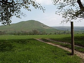
Dufton Pike
| Dufton Pike | |
|---|---|
 Dufton Pike from the West | |
<mapframe zoom="10" frameless="1" align="center" longitude="-2.4663" latitude="54.6339" height="200" width="250">{"type":"Feature","geometry":{"coordinates":[-2.4663,54.6339],"type":"Point"},"properties":{"marker-color":"#5E74F3","title":"Dufton Pike","marker-symbol":"mountain"}}</mapframe> <mapframe zoom="5" frameless="1" align="center" longitude="-2.4663" latitude="54.6339" height="200" width="250">{"type":"Feature","geometry":{"coordinates":[-2.4663,54.6339],"type":"Point"},"properties":{"marker-color":"#5E74F3","title":"Dufton Pike","marker-symbol":"mountain"}}</mapframe> <mapframe zoom="1" frameless="1" align="center" longitude="-2.4663" latitude="54.6339" height="200" width="250">{"type":"Feature","geometry":{"coordinates":[-2.4663,54.6339],"type":"Point"},"properties":{"marker-color":"#5E74F3","title":"Dufton Pike","marker-symbol":"mountain"}}</mapframe> | |
| Highest point | |
| Elevation | 481 m (1,578 ft) |
| Prominence | 163 m (535 ft) |
| Parent peak | Cross Fell |
| Listing | Marilyn |
| Coordinates | 54°38′02″N 2°27′59″W / 54.6339°N 2.4663°W |
| Geography | |
| Location | Pennines, England |
| OS grid | NY699266 |
Dufton Pike is a hill in the northern Pennines, in Cumbria, England. It is classed as a Marilyn (a hill with topographic prominence of at least 150m). It rises above the village of Dufton. Dufton Fell lies between the pike and Cow Green Reservoir.