
File:China-Historic macro areas.svg

Original file (SVG file, nominally 1,438 × 1,047 pixels, file size: 3.61 MB)
| This is a file from the Wikimedia Commons. Information from its description page there is shown below. Commons is a freely licensed media file repository. You can help. |
Summary
| Description |
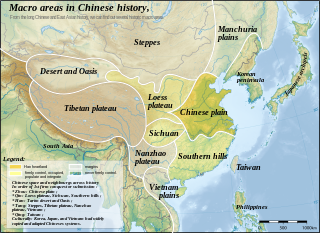
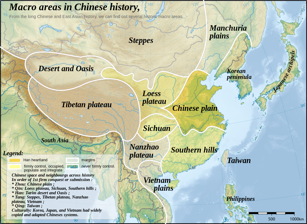
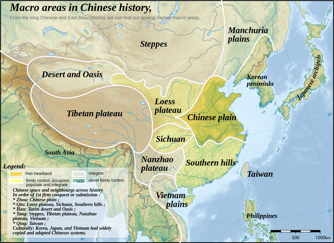
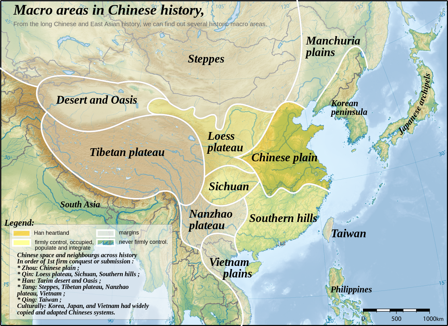
English: Topographic map of East Asia, with historical areas and macro-regions of China depicted.
中文(简体):东亚地形图。
中文(繁體):東亞地形圖。
日本語: 東アジアの地形図。
한국어: 동아시아의 지형도.
Tiếng Việt: Bản đồ địa hình khu vực Đông Á.
Català: Mapa topogràfic de l'Àsia Oriental, amb les macroàrees històriques de la Xina descrites. |
||
| Date | |||
| Source | East Asia topographic map.png by Ksiom | ||
| Author | Yug | ||
| Other versions |
File:China-Historic macro areas.svg has 2 translations.
|
||
| SVG development |
|


see also: http://uk.wikipedia.org/wiki/%D0%A4%D0%B0%D0%B9%D0%BB:China-Historic_macro_areas-uk.png
The map has been created with the Generic Mapping Tools: https://www.generic-mapping-tools.org/ using one or more of these public-domain datasets for the relief:
|

|
Permission is granted to copy, distribute and/or modify this document under the terms of the GNU Free Documentation License, Version 1.2 or any later version published by the Free Software Foundation; with no Invariant Sections, no Front-Cover Texts, and no Back-Cover Texts. A copy of the license is included in the section entitled GNU Free Documentation License. |
| This file is licensed under the Creative Commons Attribution-Share Alike 3.0 Unported license. | ||
| ||
| This licensing tag was added to this file as part of the GFDL licensing update. |
| This SVG file contains embedded text that can be translated into your language, using any capable SVG editor, text editor or the SVG Translate tool. For more information see: About translating SVG files. |
This file is translated using SVG <switch> elements. All translations are stored in the same file! Learn more.
For most Wikipedia projects, you can embed the file normally (without a To translate the text into your language, you can use the SVG Translate tool. Alternatively, you can download the file to your computer, add your translations using whatever software you're familiar with, and re-upload it with the same name. You will find help in Graphics Lab if you're not sure how to do this. |
Original upload log
This image is a derivative work of the following images:
- East Asia topographic map.png licensed with GFDL-GMT
- 2008-08-17T05:11:19Z Ksiom 2876x2094 (9245630 Bytes) {{Information |Description={{en|1=Topographic map of East Asia.}} {{ko|1=동아시아의 지형도.}} |Source=Own work by uploader |Author=[[User:Ksiom|Ksiom]] |Date=2008-08-17 |Permission={{GFDL-GMT}} |other_versions= }} [
Uploaded with derivativeFX
File history
Click on a date/time to view the file as it appeared at that time.
| Date/Time | Thumbnail | Dimensions | User | Comment | |
|---|---|---|---|---|---|
| current | 14:48, 18 September 2023 | | 1,438 × 1,047 (3.61 MB) | wikimediacommons>JoanSMF | File uploaded using svgtranslate tool (https://svgtranslate.toolforge.org/). Added translation for ca. |
File usage
The following page uses this file: