
Golßen
Golßen | |
|---|---|
 Market square and town hall | |
 Coat of arms | |
Location of Golßen within Dahme-Spreewald district <imagemap>File: Golßen in LDS.png | 240x240px poly 197 227 199 224 196 219 195 205 191 202 183 206 173 210 174 221 Alt Zauche-Wußwerk poly 110 222 120 219 128 210 126 201 113 193 108 185 100 191 103 204 107 203 114 201 116 205 Bersteland poly 78 91 71 77 75 64 81 72 94 66 94 82 93 88 93 90 Bestensee poly 225 237 237 229 239 218 236 204 223 203 221 213 212 222 206 232 Byhleguhre-Byhlen poly 61 222 58 212 50 211 51 205 68 198 72 202 77 219 Drahnsdorf poly 76 19 86 18 80 13 71 14 Eichwalde poly 81 208 78 207 73 199 50 193 45 193 65 180 83 169 93 190 104 199 Golßen poly 85 122 90 116 82 109 68 110 69 105 69 95 86 91 96 96 104 94 117 99 116 119 110 125 104 116 98 130 Groß Köris poly 99 166 89 153 85 155 83 146 77 144 80 132 81 131 87 120 99 125 103 122 103 139 121 145 118 163 108 168 Halbe poly 101 288 107 275 115 266 112 259 105 257 105 246 89 252 89 238 65 248 65 240 71 240 71 227 61 222 57 242 57 250 63 260 47 269 58 285 89 286 95 296 Heideblick poly 122 100 103 92 99 98 91 92 100 81 90 65 102 59 112 52 110 40 138 43 134 53 140 66 133 75 137 79 139 93 131 94 Heidesee poly 276 183 276 169 289 168 296 163 290 159 281 159 281 149 265 141 268 157 265 163 258 159 256 176 Jamlitz poly 110 214 113 207 114 200 105 205 92 203 81 210 74 212 74 220 Kasel-Golzig poly 84 68 102 59 107 56 110 39 116 28 105 18 108 12 100 8 94 26 83 32 83 47 78 47 69 42 63 54 73 56 Königs Wusterhausen poly 135 185 140 163 143 161 144 154 135 150 120 153 117 159 104 168 106 174 122 172 Krausnick-Groß Wasserburg poly 262 201 259 185 252 190 241 174 233 171 235 161 242 159 251 154 264 141 268 153 262 162 259 157 254 179 264 176 277 186 284 203 Lieberose poly 173 220 181 205 171 201 165 189 159 189 140 185 130 183 124 193 127 210 139 227 162 220 Lübben poly 137 288 144 276 132 275 132 266 139 242 136 238 142 226 131 211 117 221 109 221 109 216 98 215 67 222 75 239 65 239 66 246 84 238 92 247 106 245 110 259 117 270 107 277 119 289 Luckau poly 132 138 118 115 114 120 107 117 105 141 121 145 124 153 141 147 Märkisch Buchholz poly 172 197 165 187 161 185 162 157 157 148 149 141 151 134 160 122 163 117 178 125 201 130 216 147 206 159 206 172 208 180 204 182 203 195 194 189 179 185 Märkische Heide poly 59 116 66 115 72 104 69 98 77 91 71 71 75 65 80 65 76 56 64 51 68 42 51 45 56 37 44 29 38 52 44 48 40 53 52 57 36 64 38 74 56 77 66 83 67 92 61 93 Mittenwalde poly 137 143 142 137 147 128 137 122 143 116 142 103 148 103 148 99 134 93 123 98 117 103 119 120 Münchehofe poly 197 226 207 209 213 204 202 191 180 186 167 199 176 206 188 202 198 206 Neu Zauche poly 88 180 81 168 83 157 86 155 103 165 109 173 95 172 Rietzneuendorf-Staakow poly 156 186 159 165 163 155 149 164 139 163 137 173 137 184 Schlepzig poly 67 43 62 29 74 12 56 11 49 6 33 8 37 0 28 3 26 21 39 30 Schönefeld poly 124 196 124 190 132 182 121 171 93 180 84 186 98 197 99 184 107 185 115 197 Schönwald poly 68 33 74 27 74 22 78 15 75 11 64 16 59 30 Schulzendorf poly 83 125 90 113 86 108 68 107 67 113 Schwerin poly 238 214 261 206 267 203 260 188 250 190 239 174 231 168 244 160 232 154 226 146 214 149 214 141 206 156 205 175 211 183 Schwielochsee poly 224 206 209 205 206 196 201 190 203 183 210 181 220 193 229 203 Spreewaldheide poly 48 207 37 207 22 205 24 198 24 186 42 192 60 195 65 198 Steinreich poly 209 229 212 220 222 207 212 207 197 227 Straupitz (Spreewald) poly 77 143 82 130 84 122 72 112 60 114 58 134 Teupitz poly 147 167 163 154 162 145 148 141 154 134 162 120 145 125 142 137 136 151 Unterspreewald poly 82 45 85 42 83 35 72 36 68 43 Wildau poly 82 35 84 28 85 15 73 23 75 31 58 33 68 41 Zeuthen poly 195 99 196 0 297 0 297 97 297 99 Brandenburg desc bottom-right </imagemap> | |
 Golßen  Golßen | |
| Coordinates: 51°58′N 13°36′E / 51.967°N 13.600°E | |
| Country | Germany |
| State | Brandenburg |
| District | Dahme-Spreewald |
| Municipal assoc. | Unterspreewald |
| Subdivisions | 8 Ortsteile |
| Government | |
| • Mayor (2024–29) | Andrea Schulz[1] |
| Area | |
| • Total | 63.29 km2 (24.44 sq mi) |
| Elevation | 58 m (190 ft) |
| Population (2022-12-31)[2] | |
| • Total | 2,505 |
| • Density | 40/km2 (100/sq mi) |
| Time zone | UTC+01:00 (CET) |
| • Summer (DST) | UTC+02:00 (CEST) |
| Postal codes | 15938 |
| Dialling codes | 035452 |
| Vehicle registration | LDS |
Golßen (German pronunciation: [ˈɡɔlsn̩] ; Lower Sorbian: Gólišyn) or Golssen is a town in the district of Dahme-Spreewald, in Brandenburg, Germany. It is the administrative seat of the Amt ("collective municipality") Unterspreewald.
Geography
Golßen is in the northwest of Lower Lusatia, close to the border with the Brandenburgian Mittelmark core territory. The municipal area stretches from the eastern (Lower) Fläming Heath down to the Glogau-Baruth Urstromtal (glacial valley), traversed by the Dahme River. It also comprises the villages of Mahlsdorf and Zützen.
Golßen station is a stop on the Berlin–Dresden railway line. The area around the town is known for the cultivation of Spreewald gherkins.
History


The settlement arose in the course of the German Ostsiedlung eastward migration during the 11th century, possibly at the site of an earlier Slavic village of fortress. Golsyn in the March of Lusatia was first mentioned in a 1276 deed issued by the Wettin margraves. With the former march, Golßen was purchased by the Luxembourg emperor Charles IV in 1367 and incorporated into the Lands of the Bohemian Crown. The Bohemian kings temporarily put the estates around Golßen Castle in pawn to several holders, such as Margrave William I of Meissen (in 1395).
During the Thirty Years' War, the Lusatias again passed to the Wettin electors of Saxony by the 1635 Peace of Prague. Golßen Castle was built about 1723, it passed to the Counts of Solms-Baruth in the 19th century. Surrounded by extended gardens, parts of the buildings were refurbished in a Neoclassical style by Eduard Knoblauch in 1852. The neighbouring estates of Zützen were held by the Kleist noble family. A Baroque palace in Zützen, erected according to plans designed by Georg Wenzeslaus von Knobelsdorff, burnt down completely in the late days of World War II.
After the Napoleonic Wars, Golßen was incorporated into the Prussian province of Brandenburg in 1816.
Demography
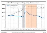
|
|
|
Politics
Seats in the municipal assembly (Stadtverordnetenversammlung) as of the 2019 local elections:
- Independent Citizen's List Golßen : 5
- Social Democratic Party of Germany (SPD): 5
- Alternative for Germany: 4
- Christian Democratic Union: 2
The mayor in Golßen is Daniela Maurer (SPD).
Notable people
- Johann Eberhard von Droste zu Zützen (1662-1726), Saxon general, commander of the fortress Königstein, and landlord
- Knut Hickethier (born 1945), media scientist
- Alfred Hoffmann (born 1958), Catholic clergyman
References
- ^ Landkreis Dahme-Spreewald Wahl der Bürgermeisterin / des Bürgermeisters. Retrieved 10 July 2024.
- ^ "Bevölkerungsentwicklung und Bevölkerungsstandim Land Brandenburg Dezember 2022" (PDF). Amt für Statistik Berlin-Brandenburg (in German). June 2023.
{{cite web}}: CS1 maint: unrecognized language (link) - ^ Detailed data sources are to be found in the Wikimedia Commons.Population Projection Brandenburg at Wikimedia Commons
