Golovinsky District
Golovinsky District
Головинский район | |
|---|---|
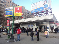
 Metro station entrance, Golovinsky District | |
| <mapframe zoom="8" frameless="1" align="center" height="320" latitude="55.55" longitude="37.45" width="270">{ "type": "ExternalData", "service": "geoshape", "properties": { "stroke-width": 1 }, "query": " SELECT ?id (if(?id = wd:, '#C12838', '#07c63e') as ?fill) (if(BOUND(?link), concat('', ?idLabel, ''), ?idLabel) as ?title) WHERE { { ?id p:P31/ps:P31/wdt:P279* wd:Q4373614 . hint:Prior hint:gearing 'forward' } UNION { ?id p:P31/ps:P31/wdt:P279* wd:Q4389092 . hint:Prior hint:gearing 'forward' } ?id p:P131 ?locst . ?locst ps:P131/wdt:P131* wd:Q649. hint:Prior hint:gearing 'forward' MINUS { ?locst pq:P582 [] } SERVICE wikibase:label { bd:serviceParam wikibase:language 'en' . ?id rdfs:label ?idLabel . } OPTIONAL {?link schema:about ?id . ?link schema:isPartOf <https://en.wikipedia.org/> . } } GROUP BY ?id ?link ?idLabel "}</mapframe> Location of Golovinsky District on the map of Moscow | |
| Country | Russia |
| Federal subject | Moscow |
| Area | |
| • Total | 8.806 km2 (3.400 sq mi) |
| Website | https://golovinskiy.mos.ru/ |
Golovinsky District (‹See Tfd›Russian: Головинский райо́н) is an administrative district (raion) of Northern Administrative Okrug, and one of the 125 raions of Moscow, Russia.[2] The area of the district is 8.806 square kilometers (3.400 sq mi). According to a 2018 estimate, the population of the district is 103,148.[1]
See also
Wikimedia Commons has media related to Golovinsky.
References
Notes
- ^ 1.0 1.1 "General Information" (in russian). Golovinsky District. Retrieved February 5, 2018.
{{cite web}}: CS1 maint: unrecognized language (link) - ^ Государственный комитет Российской Федерации по статистике. Комитет Российской Федерации по стандартизации, метрологии и сертификации. №ОК 019-95 1 января 1997 г. «Общероссийский классификатор объектов административно-территориального деления. Код 45», в ред. изменения №278/2015 от 1 января 2016 г.. (State Statistics Committee of the Russian Federation. Committee of the Russian Federation on Standardization, Metrology, and Certification. #OK 019-95 January 1, 1997 Russian Classification of Objects of Administrative Division (OKATO). Code 45, as amended by the Amendment #278/2015 of January 1, 2016. ).
Sources
Categories:
- CS1 maint: unrecognized language
- Articles containing Russian-language text
- Short description with empty Wikidata description
- Pages using infobox settlement with no coordinates
- Pages using Lang-xx templates
- Commons category link is locally defined
- Coordinates not on Wikidata
- Districts of Moscow
- Northern Administrative Okrug

