
Hermaville
Hermaville | |
|---|---|
 An aerial view of Hermaville | |
 Coat of arms | |
 Hermaville  Hermaville | |
| Coordinates: 50°19′24″N 2°35′14″E / 50.3233°N 2.5872°E | |
| Country | France |
| Region | Hauts-de-France |
| Department | Pas-de-Calais |
| Arrondissement | Arras |
| Canton | Avesnes-le-Comte |
| Intercommunality | CC Campagnes de l'Artois |
| Government | |
| • Mayor (2020–2026) | Michel Accart[1] |
| Area 1 | 6.32 km2 (2.44 sq mi) |
| Time zone | UTC+01:00 (CET) |
| • Summer (DST) | UTC+02:00 (CEST) |
| INSEE/Postal code | 62438 /62690 |
| Elevation | 85–142 m (279–466 ft) (avg. 94 m or 308 ft) |
| 1 French Land Register data, which excludes lakes, ponds, glaciers > 1 km2 (0.386 sq mi or 247 acres) and river estuaries. | |
Hermaville (French pronunciation: [ɛʁmavil]) is a commune in the Pas-de-Calais department in the Hauts-de-France region of France.[2]
Geography
A farming village situated 8 miles (13 km) west of Arras, at the junction of the D54 and the D74 roads.
Population
| Year | Pop. | ±% p.a. |
|---|---|---|
| 1968 | 329 | — |
| 1975 | 313 | −0.71% |
| 1982 | 402 | +3.64% |
| 1990 | 456 | +1.59% |
| 1999 | 455 | −0.02% |
| 2007 | 527 | +1.85% |
| 2012 | 535 | +0.30% |
| 2017 | 540 | +0.19% |
| Source: INSEE[3] | ||
Places of interest
- The church of St. Georges, dating from the seventeenth century.
- The chateau, dating from the eighteenth century.
- Traces of an old castle, destroyed in 1640 by the French.
See also
References
- ^ "Répertoire national des élus: les maires". data.gouv.fr, Plateforme ouverte des données publiques françaises (in français). 2 December 2020.
- ^ INSEE commune file
- ^ Population en historique depuis 1968, INSEE
External links
Wikimedia Commons has media related to Hermaville.
-
 Saint Georges church in winter
 -
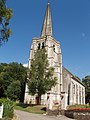 The church in summer
 -
 A niche over the church porch
 -
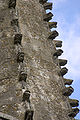 Unusual features on the spire
 -
 The Salignac-Fénelon family crypt
 -
 The farm of Saint Georges
 -

-
 The village hall


This Arras arrondissement, Pas-de-Calais geographical article is a stub. You can help Wikipedia by expanding it. |
Categories:
- CS1 français-language sources (fr)
- Use dmy dates from August 2023
- Articles with invalid date parameter in template
- Short description with empty Wikidata description
- Coordinates not on Wikidata
- Pages with French IPA
- Commons category link is defined as the pagename
- Communes of Pas-de-Calais
- Arras arrondissement geography stubs