
Kajlagarh
Kajlagarh | |
|---|---|
Village | |
 Kajlagarh Location in West Bengal, India  Kajlagarh Kajlagarh (India) | |
| Coordinates: 22°02′03″N 87°47′55″E / 22.0343°N 87.7986°E | |
| Country | |
| State | West Bengal |
| District | Purba Medinipur |
| Languages | |
| • Official | Bengali, English |
| Time zone | UTC+5:30 (IST) |
| PIN | 721626 |
| Lok Sabha constituency | Kanthi |
| Vidhan Sabha constituency | Bhagabanpur |
| Website | purbamedinipur |
Kajlagarh is a village and a gram panchayat in Bhagabanpur I CD block in Egra subdivision of Purba Medinipur district in the state of West Bengal, India.
Geography
5miles
[
{"type": "FeatureCollection",
"features": [
{ "type": "Feature",
  "properties": {
   "title": "Egra (M)",
   "description": " 21.90000,87.53000",
   "marker-symbol": "-number-F2196667876166732190000", "marker-size": "medium", "marker-color": "#800000" },
  "geometry": {"type": "Point", "coordinates": [87.53000,21.90000] }
}
, { "type": "Feature",
  "properties": {
   "title": "Amarshi Kasba (CT)",
   "description": " 22.06306,87.60222",
   "marker-symbol": "-number-F2196667876166732190000", "marker-size": "medium", "marker-color": "#C40000" },
  "geometry": {"type": "Point", "coordinates": [87.60222,22.06306] }
}
, { "type": "Feature",
  "properties": {
   "title": "Benudia (CT)",
   "description": " 22.09722,87.74444",
   "marker-symbol": "-number-F2196667876166732190000", "marker-size": "medium", "marker-color": "#A40000" },
  "geometry": {"type": "Point", "coordinates": [87.74444,22.09722] }
}
, { "type": "Feature",
  "properties": {
   "title": "Hincha Gerya (CT)",
   "description": " 22.06028,87.79944",
   "marker-symbol": "-number-F2196667876166732190000", "marker-size": "medium", "marker-color": "#C40000" },
  "geometry": {"type": "Point", "coordinates": [87.79944,22.06028] }
}
, { "type": "Feature",
  "properties": {
   "title": "Patashpur (R)",
   "description": " 22.02139,87.54500",
   "marker-symbol": "-number-F2196667876166732190000", "marker-size": "medium", "marker-color": "#C40000" },
  "geometry": {"type": "Point", "coordinates": [87.54500,22.02139] }
}
, { "type": "Feature",
  "properties": {
   "title": "Bhagabanpur (R)",
   "description": " 22.10556,87.75944",
   "marker-symbol": "-number-F2196667876166732190000", "marker-size": "medium", "marker-color": "#C40000" },
  "geometry": {"type": "Point", "coordinates": [87.75944,22.10556] }
}
, { "type": "Feature",
  "properties": {
   "title": "Pratapdighi (R)",
   "description": " 21.98639,87.60222",
   "marker-symbol": "-number-F2196667876166732190000", "marker-size": "medium", "marker-color": "#C40000" },
  "geometry": {"type": "Point", "coordinates": [87.60222,21.98639] }
}
, { "type": "Feature",
  "properties": {
   "title": "Madhabpur, Purba Medinipur (R)",
   "description": " 21.87556,87.58444",
   "marker-symbol": "-number-F2196667876166732190000", "marker-size": "medium", "marker-color": "#C40000" },
  "geometry": {"type": "Point", "coordinates": [87.58444,21.87556] }
}
, { "type": "Feature",
  "properties": {
   "title": "Tethi Bari (R)",
   "description": " 22.04444,87.80000",
   "marker-symbol": "-number-F2196667876166732190000", "marker-size": "medium", "marker-color": "#C40000" },
  "geometry": {"type": "Point", "coordinates": [87.80000,22.04444] }
}
, { "type": "Feature",
  "properties": {
   "title": "Kismat Bajkul (R)",
   "description": " 22.01389,87.81139",
   "marker-symbol": "-number-F2196667876166732190000", "marker-size": "medium", "marker-color": "#C40000" },
  "geometry": {"type": "Point", "coordinates": [87.81139,22.01389] }
}
, { "type": "Feature",
  "properties": {
   "title": "Palpara, Purba Medinipur (R)",
   "description": " 22.08306,87.66528",
   "marker-symbol": "-number-F2196667876166732190000", "marker-size": "medium", "marker-color": "#C40000" },
  "geometry": {"type": "Point", "coordinates": [87.66528,22.08306] }
}
, { "type": "Feature",
  "properties": {
   "title": "Golara Nij (R)",
   "description": " 22.07806,87.64611",
   "marker-symbol": "-number-F2196667876166732190000", "marker-size": "medium", "marker-color": "#C40000" },
  "geometry": {"type": "Point", "coordinates": [87.64611,22.07806] }
}
, { "type": "Feature",
  "properties": {
   "title": "Gangadharbar (R)",
   "description": " 21.89139,87.64056",
   "marker-symbol": "-number-F2196667876166732190000", "marker-size": "medium", "marker-color": "#C40000" },
  "geometry": {"type": "Point", "coordinates": [87.64056,21.89139] }
}
, { "type": "Feature",
  "properties": {
   "title": "Ramchandrapur, Purba Medinipur (R)",
   "description": " 21.80833,87.49806",
   "marker-symbol": "-number-F2196667876166732190000", "marker-size": "medium", "marker-color": "#C40000" },
  "geometry": {"type": "Point", "coordinates": [87.49806,21.80833] }
}
, { "type": "Feature",
  "properties": {
   "title": "Kajlagarh (R)",
   "description": " 22.03056,87.81111",
   "marker-symbol": "-number-F2196667876166732190000", "marker-size": "medium", "marker-color": "#000000" },
  "geometry": {"type": "Point", "coordinates": [87.81111,22.03056] }
}
, { "type": "Feature",
  "properties": {
   "title": "Paikbheri (H)",
   "description": " 22.11083,87.72333",
   "marker-symbol": "-number-F2196667876166732190000", "marker-size": "medium", "marker-color": "#AA6666" },
  "geometry": {"type": "Point", "coordinates": [87.72333,22.11083] }
}
, { "type": "Feature",
  "properties": {
   "title": "Panchrol (H)",
   "description": " 21.83306,87.45250",
   "marker-symbol": "-number-F2196667876166732190000", "marker-size": "medium", "marker-color": "#AA6666" },
  "geometry": {"type": "Point", "coordinates": [87.45250,21.83306] }
}
, { "type": "Feature",
  "properties": {
   "title": "Alangiri (H)",
   "description": " 21.85333,87.46750",
   "marker-symbol": "-number-F2196667876166732190000", "marker-size": "medium", "marker-color": "#AA6666" },
  "geometry": {"type": "Point", "coordinates": [87.46750,21.85333] }
}
]
}
M: municipal city/ town, CT: census town, R: rural/ urban centre, H: historical/ religious centre.
Owing to space constraints in the small map, the actual locations in a larger map may vary slightly
Location
Kajlagarh is located at 22°02′03″N 87°47′55″E / 22.0343°N 87.7986°E.
Urbanisation
96.96% of the population of Egra subdivision live in the rural areas. Only 3.04% of the population live in the urban areas, and that is the lowest proportion of urban population amongst the four subdivisions in Purba Medinipur district.[1]
Civic administration
CD block HQ
The headquarters of Bhagabanpur I CD block are located at Kajlagarh.[2]
Transport
Kajlagarh is on Egra-Bajkul Road.[3]
The nearest railway station, Deshapran railway station, is on the Tamluk-Digha line, constructed in 2003–04.[4][5]
Education
Bajkul Milani Mahavidyalaya was established at Tethi Bari mouza, PO Kismat Bajkul, in 1964. It is affiliated to Vidyasagar University.[6]
Culture
David J. McCutchion mentions the Gopala temple as an 18th-century West Bengal Navaratna, measuring 35' 3" square, having slight terracotta.[7]
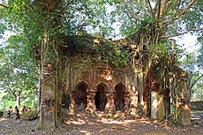
Kajlagarh picture gallery
-
 Rajbari temple
 -
 Gopala temple of Chowdhury family


Healthcare
There is a primary health centre at Kajlagarh (with 6 beds).[8]
References
- ^ "District Statistical Handbook 2014 Purba Medinipur". Table 2.2. Department of Planning and Statistics, Government of West Bengal. Retrieved 17 April 2019.
- ^ "BDO Offices under Purba Medinipur district". West Bengal Public Library Network, Government of West Bengal. Retrieved 23 April 2019.
- ^ Google maps
- ^ "68689 Santragachi-Digha EMU". Time Table. indiarailinfo. Retrieved 30 March 2017.
- ^ "Year of construction of important BG lines" (PDF). History. South Eastern Railway. Archived from the original (PDF) on 13 May 2015. Retrieved 1 July 2016.
- ^ "Bajkul Milani Mahavidyalaya". BMM. Retrieved 30 March 2017.
- ^ McCutchion, David J., Late Mediaeval Temples of Bengal, first published 1972, reprinted 2017, pages 51. The Asiatic Society, Kolkata, ISBN 978-93-81574-65-2
- ^ "Health & Family Welfare Department". Health Statistics. Government of West Bengal. Retrieved 27 March 2019.
External links
| External videos | |
|---|---|
Cities, towns, locations and neighbourhoods in Purba Medinipur District, Medinipur division | ||||||||||
|---|---|---|---|---|---|---|---|---|---|---|
| Cities, municipal and census towns |
|  | ||||||||
| Locations other than cities and towns |
| |||||||||
| Neighbourhoods |
| |||||||||
| Related topics | ||||||||||
Lua error in mw.title.lua at line 346: bad argument #2 to 'title.new' (unrecognized namespace name 'Portal'). | ||||||||||
This article about a location in the Purba Medinipur district of West Bengal is a stub. You can help Wikipedia by expanding it. |