
Liebenwalde
Liebenwalde | |
|---|---|
 Kreuzbruch church | |
 Coat of arms | |
Location of Liebenwalde within Oberhavel district <imagemap>File: Liebenwalde in OHV.png | 240x240px poly 242 77 236 77 229 83 221 85 219 84 212 88 206 85 206 80 201 77 201 75 201 69 209 62 203 58 206 53 203 56 205 53 201 53 201 41 199 39 196 52 193 53 186 51 181 46 175 44 173 41 169 41 168 44 163 44 160 38 156 33 156 30 161 29 163 25 169 25 171 18 176 17 177 9 184 7 189 4 192 5 196 5 201 16 209 17 212 12 213 16 211 22 223 23 224 31 228 34 224 42 225 44 223 51 225 54 225 59 232 65 233 68 243 73 243 78 Fürstenberg/Havel poly 281 123 278 124 275 125 264 127 260 134 253 136 251 134 247 135 241 134 237 135 236 144 233 147 229 140 226 141 222 144 218 145 211 150 207 143 215 139 212 135 213 131 204 125 204 110 214 103 205 102 210 89 215 88 221 85 230 85 238 79 246 78 248 88 253 87 253 100 261 103 264 101 266 103 267 108 274 110 278 114 276 119 280 120 273 126 280 120 Zehdenick poly 286 190 279 190 277 189 276 195 272 194 256 197 243 200 234 194 233 188 218 187 217 186 213 187 212 184 220 175 227 170 232 169 232 166 234 162 239 157 237 153 246 137 251 136 253 142 261 142 254 145 254 150 259 154 260 148 268 151 269 148 272 153 268 161 277 166 271 167 271 175 284 185 281 188 285 190 279 190 Liebenwalde poly 256 196 242 199 235 195 229 188 215 186 213 191 207 193 201 192 188 198 188 204 181 207 184 208 173 215 170 220 181 223 182 230 188 228 192 233 192 229 194 228 193 224 197 224 198 230 199 236 201 236 211 239 212 233 215 230 215 226 216 224 233 231 238 236 246 237 246 242 254 243 255 237 256 235 252 226 256 217 252 213 253 208 261 205 257 202 257 198 Oranienburg poly 256 256 253 252 255 243 246 242 244 237 243 246 238 248 238 255 232 254 229 260 229 266 233 264 234 269 241 270 240 274 244 274 250 270 249 266 255 259 Mühlenbecker Land poly 239 276 238 273 239 270 236 269 233 270 232 265 229 267 229 272 224 273 226 276 Glienicke/Nordbahn poly 242 237 236 235 232 231 229 232 229 238 221 238 223 237 217 240 218 248 216 253 228 248 229 242 242 245 244 238 Birkenwerder poly 230 230 229 237 221 236 215 240 208 244 205 241 209 238 211 237 213 231 215 230 215 226 216 224 229 231 Hohen Neuendorf poly 242 243 230 242 229 247 215 252 218 246 212 247 208 248 214 254 211 267 215 271 218 268 221 268 222 261 229 260 233 255 239 256 237 248 243 246 243 243 Hohen Neuendorf poly 217 272 214 274 211 275 207 272 204 278 202 279 201 282 204 287 201 289 190 286 185 280 192 280 193 278 198 277 193 274 192 270 195 265 195 260 197 259 201 261 205 255 211 256 209 251 212 251 213 254 212 262 Hennigsdorf poly 198 223 192 223 194 226 192 229 192 240 199 239 199 231 198 227 198 224 Leegebruch poly 213 241 209 244 204 242 206 238 201 236 198 239 192 239 192 235 184 240 188 243 189 253 193 256 196 256 197 260 202 261 210 256 209 252 210 248 215 245 212 242 Velten poly 154 254 161 255 167 252 174 252 174 257 171 258 174 262 178 271 190 272 190 277 186 279 189 284 192 282 193 279 196 277 192 274 194 269 195 256 190 249 189 241 185 239 192 235 190 228 186 228 182 231 181 224 178 222 169 222 160 228 161 234 154 234 152 238 147 239 147 246 154 247 154 254 Oberkrämer poly 104 246 114 239 119 239 121 234 127 234 127 231 134 231 136 233 141 235 141 240 145 238 153 238 155 232 162 231 160 229 167 223 170 220 170 215 176 212 184 210 181 207 188 204 188 197 182 192 181 196 178 196 173 199 169 197 169 182 171 180 176 182 174 175 176 166 170 158 165 160 164 164 161 164 160 173 159 176 154 175 151 171 149 171 148 174 146 175 142 173 143 178 144 184 140 185 145 187 139 192 137 196 133 198 127 205 127 220 114 231 115 235 108 238 104 240 Kremmen poly 214 191 208 192 201 192 197 194 188 197 183 190 178 195 170 197 169 180 175 181 173 176 176 165 171 157 165 159 164 164 161 164 160 170 158 163 155 163 153 153 161 146 163 132 168 134 169 131 173 132 176 134 178 131 190 132 204 132 211 134 212 137 213 139 206 145 210 151 218 144 223 145 226 141 228 142 231 147 235 145 236 136 242 135 246 136 238 151 238 158 235 162 231 163 231 168 221 172 219 174 218 174 211 182 Löwenberger Land poly 184 68 183 70 180 71 182 75 186 73 Gransee poly 212 133 202 131 190 132 177 132 170 131 167 134 163 133 166 124 178 125 178 121 181 116 182 108 185 107 185 95 190 94 190 90 176 88 178 82 181 80 183 84 190 83 186 80 189 73 189 65 184 63 183 58 191 54 195 53 199 40 201 40 201 53 204 55 203 59 208 63 200 68 201 79 204 80 204 84 209 89 206 97 206 102 214 103 204 111 204 125 211 130 211 132 Gransee poly 181 116 173 117 171 114 167 111 174 102 180 101 185 102 184 107 180 108 180 116 Schönermark poly 177 118 177 124 167 125 158 127 160 116 153 116 152 112 150 111 156 105 154 89 160 89 164 87 164 93 170 96 175 91 185 95 184 101 182 100 176 101 168 111 172 113 172 117 178 116 176 122 Sonnenberg poly 187 94 174 91 171 97 165 94 166 88 161 89 154 88 156 86 163 86 163 80 168 77 165 75 168 70 169 66 169 57 177 54 181 56 186 53 191 55 184 62 187 67 183 68 182 70 181 74 187 73 189 76 186 79 187 83 184 81 181 79 176 86 189 91 Großwoltersdorf poly 162 86 156 85 156 79 144 78 139 75 138 73 136 74 133 68 135 68 136 61 138 56 144 56 148 54 152 50 154 48 149 46 146 46 146 43 143 39 151 38 153 33 156 36 160 40 160 44 167 44 168 41 172 41 173 44 179 46 183 51 184 53 179 54 177 53 169 55 170 61 166 68 164 72 168 78 162 79 Stechlin poly 186 76 189 75 188 67 185 68 Großwoltersdorf poly 298 297 298 293 289 291 285 289 279 288 278 277 285 268 276 263 274 257 270 258 270 263 264 264 257 270 252 262 249 265 247 274 225 274 229 272 227 261 222 261 221 270 217 268 215 272 211 275 207 272 204 277 201 281 205 287 189 286 185 291 187 297 Berlin poly 224 0 213 2 208 18 205 16 201 15 197 9 197 5 187 4 181 8 177 7 175 17 170 18 167 23 162 23 158 28 155 29 154 34 148 37 143 38 140 32 134 34 139 31 143 31 140 25 132 24 130 28 128 25 118 27 116 32 106 23 88 27 80 22 84 16 81 13 64 10 59 7 61 3 60 0 Mecklenburg-Vorpommern poly 52 0 44 2 42 4 34 0 Mecklenburg-Vorpommern desc bottom-right </imagemap> | |
 Liebenwalde  Liebenwalde | |
| Coordinates: 52°52′N 13°24′E / 52.867°N 13.400°E | |
| Country | Germany |
| State | Brandenburg |
| District | Oberhavel |
| Subdivisions | 6 districts |
| Government | |
| • Mayor (2019–27) | Jörn Lehmann[1] |
| Area | |
| • Total | 138.84 km2 (53.61 sq mi) |
| Elevation | 41 m (135 ft) |
| Population (2022-12-31)[2] | |
| • Total | 4,481 |
| • Density | 32/km2 (84/sq mi) |
| Time zone | UTC+01:00 (CET) |
| • Summer (DST) | UTC+02:00 (CEST) |
| Postal codes | 16559 |
| Dialling codes | 033054 |
| Vehicle registration | OHV |
| Website | www.liebenwalde.de |
Liebenwalde is a town in the Oberhavel district, in Brandenburg, in north-eastern Germany. It is situated 16 km (10 mi) northeast of Oranienburg, and 39 km (24 mi) north of Berlin (centre).
History
In 1319, the town was captured by Henry II, Lord of Mecklenburg, then in mid-1320 it was captured by Wartislaw IV, Duke of Pomerania, and recaptured by Henry II by the end of 1320.[3] Afterwards it passed to the Margraviate of Brandenburg, and from 1373 to 1415 it was part of the Lands of the Bohemian (Czech) Crown.
In 2003, the administrative boundaries were expanded to include Freienhagen, Hammer, Kreuzbruch, Liebenthal and Neuholland.
Demography
-
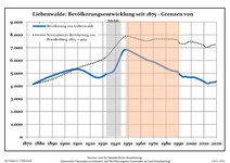 Development of Population since 1875 within the Current Boundaries (Blue Line: Population; Dotted Line: Comparison to Population Development of Brandenburg state; Grey Background: Time of Nazi rule; Red Background: Time of Communist rule)
 -
 Recent Population Development and Projections (Population Development before Census 2011 (blue line); Recent Population Development according to the Census in Germany in 2011 (blue bordered line); Official projections for 2005-2030 (yellow line); for 2020-2030 (green line); for 2017-2030 (scarlet line)
|
|
|
References
- ^ Landkreis Oberhavel Wahl der Bürgermeisterin / des Bürgermeisters, accessed 2 July 2021.
- ^ "Bevölkerungsentwicklung und Bevölkerungsstandim Land Brandenburg Dezember 2022" (PDF). Amt für Statistik Berlin-Brandenburg (in German). June 2023.
{{cite web}}: CS1 maint: unrecognized language (link) - ^ Rymar, Edward (1979). "Rywalizacja o ziemię lubuską i kasztelanię międzyrzecką w latach 1319–1326, ze szczególnym uwzględnieniem stosunków pomorsko-śląskch". Śląski Kwartalnik Historyczny Sobótka (in polski). XXXIV (4). Wrocław: Zakład Narodowy im. Ossolińskich, Wydawnictwo Polskiej Akademii Nauk: 477, 485–486.
- ^ Detailed data sources are to be found in the Wikimedia Commons.Population Projection Brandenburg at Wikimedia Commons

Towns and municipalities in Oberhavel | ||
|---|---|---|
 | ||
This Brandenburg location article is a stub. You can help Wikipedia by expanding it. |