
Marckolsheim
You can help expand this article with text translated from the corresponding article in français. (December 2008) Click [show] for important translation instructions.
|
Marckolsheim
Màrkelse | |
|---|---|
 Barge in the lock beside the power station | |
 Coat of arms | |
 Marckolsheim  Marckolsheim | |
| Coordinates: 48°10′N 7°32′E / 48.16°N 7.54°E | |
| Country | France |
| Region | Grand Est |
| Department | Bas-Rhin |
| Arrondissement | Sélestat-Erstein |
| Canton | Sélestat |
| Intercommunality | Ried de Marckolsheim |
| Government | |
| • Mayor (2020–2026) | Frédéric Pfliegersdoerffer[1] |
| Area 1 | 33.36 km2 (12.88 sq mi) |
| Time zone | UTC+01:00 (CET) |
| • Summer (DST) | UTC+02:00 (CEST) |
| INSEE/Postal code | 67281 /67390 |
| Elevation | 170–184 m (558–604 ft) |
| 1 French Land Register data, which excludes lakes, ponds, glaciers > 1 km2 (0.386 sq mi or 247 acres) and river estuaries. | |
Marckolsheim (‹See Tfd›German: Markolsheim) is a commune in the Bas-Rhin department in Alsace in north-eastern France.[2]
On the eastern edge of the town the Casemate de Marckolsheim Sud, a Maginot Line fortification left over from the Second World War, has been converted into a small museum. Approximately 3 kilometres to the east the Rhine has been dammed and a hydro-electric power station installed.
Population
| Year | Pop. | ±% p.a. |
|---|---|---|
| 1968 | 3,328 | — |
| 1975 | 2,779 | −2.54% |
| 1982 | 3,124 | +1.69% |
| 1990 | 3,306 | +0.71% |
| 1999 | 3,614 | +0.99% |
| 2007 | 4,185 | +1.85% |
| 2012 | 4,171 | −0.07% |
| 2017 | 4,151 | −0.10% |
| Source: INSEE[3] | ||
Gallery
-
 Rue du Maréchal Foch near the townhall
 -
 Rue du Maréchal Foch near Rue Clemenceau
 -
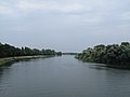 The Rhine near Marckolsheim


See also
References
- ^ "Répertoire national des élus: les maires" (in français). data.gouv.fr, Plateforme ouverte des données publiques françaises. 13 September 2022.
- ^ INSEE commune file
- ^ Population en historique depuis 1968, INSEE
Wikimedia Commons has media related to Marckolsheim.
This Bas-Rhin geographical article is a stub. You can help Wikipedia by expanding it. |