Marpingen
Marpingen | |
|---|---|
 | |
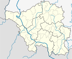
Location of Marpingen within Sankt Wendel district <imagemap>File: Marpingen in WND.svg | 240x240px poly 47 391 74 583 193 659 362 550 538 633 512 954 588 1037 548 1097 585 1246 538 1369 542 1641 628 1687 644 1621 790 1621 989 1459 979 1309 860 1250 820 1140 863 1090 814 1017 837 881 986 878 1029 765 933 742 910 643 996 682 1145 656 1158 440 1082 440 996 391 963 248 880 148 751 291 717 235 784 82 681 82 538 225 469 225 472 109 356 158 402 291 333 397 177 341 Nonnweiler poly 887 145 966 235 993 381 1082 437 1149 420 1152 659 999 682 906 649 933 739 1026 762 979 881 863 888 814 1021 857 1070 827 1137 863 1243 973 1303 983 1462 1112 1495 1212 1465 1314 1465 1364 1336 1520 1286 1487 1170 1537 1120 1722 1107 1775 1153 1848 1143 1898 1084 1954 1253 2051 1246 2117 1163 2163 1027 2240 1017 2409 885 2412 769 2260 802 2144 679 2124 483 1961 490 1925 556 1596 424 1507 553 1291 135 Nohfelden poly 2406 878 2246 1021 2173 1024 2110 1157 2177 1180 2193 1250 2359 1256 2379 1664 2449 1707 2508 1595 2823 1737 2847 1667 2946 1641 3012 1551 3036 1435 3155 1435 3082 1326 3085 1233 3042 1303 2880 1256 2890 1034 2794 838 2830 696 2797 676 2764 775 2601 891 2419 911 2406 868 Freisen poly 558 1648 362 1724 260 1714 220 1797 326 1913 299 1993 230 1986 240 2062 362 2192 508 2105 585 1953 664 1943 668 2105 727 2165 717 2361 777 2387 847 2566 923 2520 943 2410 1076 2404 1079 2321 1208 2215 1248 1983 1334 1873 1288 1674 1324 1585 1225 1465 1109 1502 993 1459 804 1614 651 1618 641 1684 Tholey poly 1228 1465 1331 1578 1285 1674 1318 1803 1404 1721 1457 1737 1812 1618 1769 1399 1918 1206 1898 1097 1855 1150 1782 1150 1736 1107 1563 1114 1493 1167 1530 1279 1371 1329 1321 1468 Oberthal poly 1321 1794 1341 1870 1245 1996 1215 2218 1082 2318 1076 2407 943 2400 930 2530 847 2570 1029 2639 1046 2722 1192 2742 1238 2699 1328 2888 1497 2888 1659 2732 1629 2573 1570 2530 1576 2361 1706 2271 1560 2231 1527 1976 1464 1910 1457 1730 1414 1704 Marpingen poly 1918 1193 1775 1412 1812 1614 1911 1658 1968 1760 1984 1936 2097 1916 2104 1843 2180 1760 2266 1760 2389 1671 2356 1538 2352 1253 2203 1253 2173 1187 2120 1163 2057 1256 1964 1253 Namborn poly 1666 2732 1696 2659 1815 2659 1882 2789 2041 2815 2439 2493 2648 2653 2747 2596 2770 2477 2694 2397 3003 2245 3142 2062 3062 1923 2933 1939 2979 1734 2956 1651 2860 1658 2813 1730 2754 1727 2505 1588 2442 1697 2389 1664 2270 1764 2197 1760 2100 1830 2097 1916 1991 1926 1991 1780 1915 1658 1809 1621 1470 1737 1457 1903 1527 1986 1563 2221 1702 2274 1580 2357 1573 2536 1636 2576 Sankt Wendel poly 8 2 8 429 41 380 160 340 329 396 409 297 356 147 475 104 465 210 532 214 671 88 787 78 727 220 744 290 880 131 1291 137 1510 552 1606 423 1918 552 1958 489 2120 479 2134 662 2253 791 2422 761 2425 907 2588 894 2797 685 2830 695 2804 827 2903 1026 2916 1245 3036 1295 3089 1229 3092 1302 3162 1444 3049 1441 3019 1560 2963 1637 2989 1716 2946 1925 3079 1912 3152 2061 3022 2241 2724 2400 2777 2480 2764 2606 2800 2669 2936 2692 3056 2878 3085 2934 3228 2931 3228 3 Rhineland-Palatinate poly 47 401 4 437 4 2022 51 1966 144 1939 280 1707 369 1717 545 1634 528 1349 568 1253 548 1087 575 1031 498 944 532 649 362 550 200 672 87 600 Merzig-Wadern poly 226 1813 147 1939 57 1966 1 2029 14 2938 319 2934 290 2891 409 2699 469 2755 545 2752 644 2653 734 2649 840 2570 777 2394 717 2354 717 2165 668 2122 651 1946 595 1946 522 2095 362 2188 240 2079 226 1976 290 1993 319 1913 Saarlouis (district) poly 323 2938 296 2895 416 2706 475 2742 542 2742 638 2639 724 2639 847 2570 1039 2653 1032 2729 1198 2745 1241 2686 1338 2895 1484 2895 1600 2848 1666 2739 1706 2653 1802 2659 1868 2785 2034 2815 2329 2626 2425 2503 2644 2659 2747 2619 2797 2692 2923 2702 3052 2895 3062 2938 Neunkirchen (German district) desc bottom-right </imagemap> | |
| Coordinates: 49°27′N 7°3′E / 49.450°N 7.050°E | |
| Country | Germany |
| State | Saarland |
| District | Sankt Wendel |
| Subdivisions | 4 |
| Government | |
| • Mayor (2016–26) | Volker Weber[1] (SPD) |
| Area | |
| • Total | 39.68 km2 (15.32 sq mi) |
| Elevation | 301 m (988 ft) |
| Population (2022-12-31)[2] | |
| • Total | 9,935 |
| • Density | 250/km2 (650/sq mi) |
| Time zone | UTC+01:00 (CET) |
| • Summer (DST) | UTC+02:00 (CEST) |
| Postal codes | 66646 |
| Dialling codes | 06827, 06853 |
| Vehicle registration | WND |
| Website | www.marpingen.de |
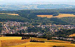
Marpingen is a municipality in the district of Sankt Wendel, in Saarland, Germany. It is situated approximately 8 km west of Sankt Wendel, and 25 km north of Saarbrücken.
The municipality contains the urban areas Marpingen, Urexweiler, Alsweiler und Berschweiler, which have the status of Ortschaft, and Rheinstraße, which is in the administrative area of Marpingen, and Habenichts, which is in the administrative area of Urexweiler.
History
In 1876, at the height of the Kulturkampf, Marpingen was claimed to be the site of an apparition of the Virgin Mary, leading to a major conflict between the Prussian Government and the believers who flocked to Marpingen as a result.[3]
See also
References
- ^ Gewählte Ober-/Bürgermeister*innen, Landrät*innen und Regionalverbandsdirektor*in im Saarland, Statistisches Amt des Saarlandes, 27 March 2022.
- ^ "Fläche und Bevölkerung - Stand: 31.12.2022 (Basis Zensus 2011)" (PDF) (in German). Statistisches Amt des Saarlandes. June 2023.
{{cite web}}: CS1 maint: unrecognized language (link) - ^ Blackbourn, David (1994). Marpingen: Apparitions of the Virgin Mary in Nineteenth-Century Germany. New York: Alfred A Knopf. ISBN 0-679-41843-1.
External links
- "The Marian apparitions at Marpingen" – multi-part summary and commentary on Blackbourn's book on the Marpingen visions
- Marpingen pilgrimage


