
Oberaargletscher
| Oberaargletscher | |
|---|---|
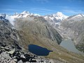
 Oberaarsee and Oberaargletscher | |
 Oberaargletscher  Oberaargletscher | |
| Location | Bern, Switzerland |
| Coordinates | 46°31′59″N 8°12′37″E / 46.53306°N 8.21028°E |
| Length | 4 km |
| Lua error in Module:Mapframe at line 384: attempt to perform arithmetic on local 'lat_d' (a nil value). | |
The Oberaargletscher (German: [ˈoːbəraːrˌglɛtʃər]), literally "Upper Aare-Glacier", is a 4 km (2.5 mi) long glacier (2005) situated in the Bernese Alps in the canton of Bern in Switzerland. In 1973 it had an area of 5.82 km2 (2.25 sq mi). The lower end of this glacier lies almost 400 m higher than the (original) lower end of neighbouring Unteraargletscher.
Gallery
-
 Oberaargletscher (left hand in the background) and Unteraargletscher (on the right). The small blue lake left hand in front is the Triebtenseewli.
 -
 Upper Aargletscher as seen from the bank of the reserve lake Oberaarsee in July, 2010


See also
- List of glaciers in Switzerland
- List of glaciers
- Retreat of glaciers since 1850
- Swiss Alps
- Rhône Glacier
External links
- Swiss glacier monitoring network
- Ober- and Unteraargletscher in the Topografic Atlas of Switzerland from 1870–1922
- "Before/after comparison of Oberaar glacier (Bernese Alps)", SwissGlaciers.org, Simon Oberli
This article about a glacier in the canton of Bern is a stub. You can help Wikipedia by expanding it. |