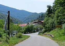
Podbela
Podbela | |
|---|---|
 | |
| Coordinates: 46°14′49.59″N 13°27′22.36″E / 46.2471083°N 13.4562111°E | |
| Country | |
| Traditional region | Slovenian Littoral |
| Statistical region | Gorizia |
| Municipality | Kobarid |
| Area | |
| • Total | 5.87 km2 (2.27 sq mi) |
| Elevation | 312.6 m (1,025.6 ft) |
| Population (2002) | |
| • Total | 85 |
| [1] | |
Podbela (pronounced [pɔdˈbeːla]; Italian: Sant'Elena al Natisone, before 1927 Podibela[2]) is a small village on the left bank of the Nadiža River in the Municipality of Kobarid in the Littoral region of Slovenia. It is located in the Breginj Combe.
Church

The church southwest of the settlement is dedicated to Saint Helen. It dates from the 16th century. It was greatly damaged in the 1976 Friuli earthquake and then restored.[3]
References
- ^ Statistical Office of the Republic of Slovenia
- ^ "Amministrazione". Archived from the original on 2011-07-19. Retrieved 2010-06-09. Podbela during Italian rule (1918-1947)
- ^ Slovenian Ministry of Culture register of national heritage reference number ešd 3986
External links
 Media related to Podbela at Wikimedia Commons
- Podbela on Geopedia
Categories:
- Short description with empty Wikidata description
- Coordinates not on Wikidata
- Pages with Slovene IPA
- Articles containing Italian-language text
- Pages using Lang-xx templates
- Commons category link is defined as the pagename
- Populated places in the Municipality of Kobarid
- Goriška statistical region geography stubs

