Storehorn
| Storehorn | |
|---|---|
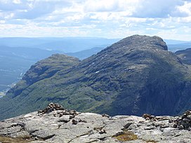
 Storehorn (right summit) in the summer as seen from Totten. | |
<mapframe zoom="10" frameless="1" align="center" longitude="8.5933333333333" latitude="60.816944444444" height="200" width="250">{"type":"Feature","geometry":{"coordinates":[8.593333333333334,60.816944444444445],"type":"Point"},"properties":{"marker-color":"#5E74F3","title":"Storehorn","marker-symbol":"mountain"}}</mapframe> <mapframe zoom="5" frameless="1" align="center" longitude="8.5933333333333" latitude="60.816944444444" height="200" width="250">{"type":"Feature","geometry":{"coordinates":[8.593333333333334,60.816944444444445],"type":"Point"},"properties":{"marker-color":"#5E74F3","title":"Storehorn","marker-symbol":"mountain"}}</mapframe> <mapframe zoom="1" frameless="1" align="center" longitude="8.5933333333333" latitude="60.816944444444" height="200" width="250">{"type":"Feature","geometry":{"coordinates":[8.593333333333334,60.816944444444445],"type":"Point"},"properties":{"marker-color":"#5E74F3","title":"Storehorn","marker-symbol":"mountain"}}</mapframe> | |
| Highest point | |
| Elevation | 1,482 m (4,862 ft) |
| Coordinates | 60°49′1″N 8°35′36″E / 60.81694°N 8.59333°E |
| Geography | |
| Location | Hemsedal (Buskerud) |
| Topo map | 1616 IV Hemsedal |
Storehorn, also written Storehødn, is a mountain located in the Hemsedal municipality. It is a part of Hemsedal Top 20.