Tagalaht
| Tagalaht | |
|---|---|
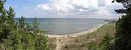
| Tagga Bay, Taggaviken | |
 Tagalaht Bay Panorama | |
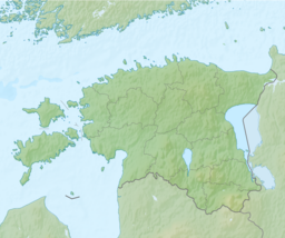
| Location | Saare County, Estonia |
| Coordinates | 58°31′N 22°4′E / 58.517°N 22.067°E |
| Type | Bay |
| Part of | Baltic Sea |
Tagalaht (Swedish: Taggaviken) is a bay in the Baltic Sea, on the north-west coast of Saaremaa Island in Estonia, situated between the Tagamõisa Peninsula (‹See Tfd›German: Hundsort) and Ninase (Cape Ninnast). During World War I, the bay, guarded by Russian beach forts at Hundsort and Ninnast, was the main landing point for German troops during Operation Albion in October 1917, when Saaremaa was occupied.[1]
References
- ^ Barrett, Michael B. Operation Albion: The German Conquest of the Baltic Islands. Indiana University Press: Bloomington, IN. ISBN 978-0-253-34969-9
Categories:
- Short description with empty Wikidata description
- Coordinates not on Wikidata
- Articles using infobox body of water without alt
- Articles using infobox body of water without pushpin map alt
- Articles using infobox body of water without image bathymetry
- Articles containing Swedish-language text
- Pages using Lang-xx templates
- Articles containing German-language text
- Bays of Estonia
- Saaremaa Parish
- Bays of the Baltic Sea
- Landforms of Saare County
- Estonia geography stubs
