
Telkibánya
Coordinates: Coordinates: Missing latitude
Telkibánya | |
|---|---|
Village | |
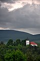
 Aerial photography of Telkibánya | |
 Flag  Coat of arms | |
| Lua error in Module:Location_map at line 411: Malformed coordinates value. | |
| Coordinates: Coordinates: Missing latitude Invalid arguments have been passed to the {{#coordinates:}} function | |
| Country | Hungary |
| Region | Northern Hungary |
| County | Borsod-Abaúj-Zemplén |
| Government | |
| • Mayor | Lászlóné Mester |
| Area | |
| • Total | 46.82 km2 (18.08 sq mi) |
| Population (2015)[2] | |
| • Total | 549 |
| • Density | 12/km2 (30/sq mi) |
| Time zone | UTC+1 (CET) |
| • Summer (DST) | UTC+2 (CEST) |
| Postal code | 3896 |
| Area code | +36 46 |
Telkibánya is a village in Borsod-Abaúj-Zemplén county, in the Northern Hungary region of northeastern Hungary.
Telkibánya was a notable mining town during the 15th century, known for its gold and silver. Its prosperity declined after a mining accident in the 17th century, but the area's natural beauty and hiking trails make it a great spot for recreation.
Geography
It covers an area of 46.82 km2 (18 sq mi) and has a population of 549 people (2015).[2]
Main Sights
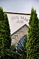
- Protestant cemetery and church
- St. Catherine zion
- Mining Museum
- Ruins of Koncfalva
- Ice cave
- Mining pits and former gold washing claims
- Surface minerals
- Surface perlite flow
Gallery
- Photos of Telkibánya
-
 Protestant cemetery
 -
 Protestant church
 -
 runes and St. Catherine zion
 -
 Altar of St. Catherine painted by Zoltán Joó
 -
 Cemetery at the Protestant church
 -
 Protestant church from the Bizsóka
 -
 Unitarist church front


References
- ^ Telkibánya at the Hungarian Central Statistical Office (Hungarian).
- ^ 2.0 2.1 Gazetteer of Hungary, 1st January 2015. Hungarian Central Statistical Office. 3 September 2015
External links
Wikimedia Commons has media related to Telkibánya.


This Borsod-Abaúj-Zemplén location article is a stub. You can help Wikipedia by expanding it. |