
Template:Canada provinces map
Usage
Add {{Canada provinces map}} in articles pertaining provinces and territories of Canada.
Simple syntax: <syntaxhighlight lang="wikitext">
</syntaxhighlight> A Canada provinces map with linked labels will be rendered.
Complete syntax: <syntaxhighlight lang="wikitext">

</syntaxhighlight>
Parameters
The prefix and XY parameters are used to adjust the wikilinks for the provinces and territories.
| Parameter | Default | Usage |
|---|---|---|
align |
right |
Possible values are left, right, center, and none
|
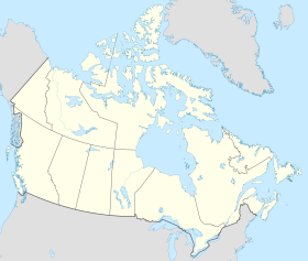
map |
Canada-provinces layout.png |
Any image can be used, but be careful to make sure the labels are aligned with the provinces and territories |
prefix |
blank | text to use to prefix each link (for example, Geography of)
|
BC |
British Columbia |
name of an article (overrides the prefix parameter)
|
SK |
Saskatchewan |
name of an article (overrides the prefix parameter)
|
MB |
Manitoba |
name of an article (overrides the prefix parameter)
|
NB |
New Brunswick |
name of an article (overrides the prefix parameter)
|
PE |
Prince Edward Island |
name of an article (overrides the prefix parameter)
|
NS |
Nova Scotia |
name of an article (overrides the prefix parameter)
|
NL |
Newfoundland and Labrador |
name of an article (overrides the prefix parameter)
|
width |
280px |
|
border |
blank | set to none to remove the border (which is useful when there is no image, and the map is embedded in a table or sidebar)
|
caption |
blank | use to add a caption to the image |