
Templin
Templin | |
|---|---|
 Town hall | |
 Coat of arms | |
Location of Templin within Uckermark district <imagemap>File: Templin in UM.png | 240x240px poly 193 295 186 282 176 278 159 283 152 272 154 260 166 246 147 242 141 237 155 228 166 220 175 208 183 208 190 205 198 216 194 222 200 231 210 233 207 247 215 256 228 267 233 275 Angermünde poly 57 194 54 189 36 189 40 175 52 151 55 161 65 151 69 133 73 133 80 150 93 149 98 155 107 157 105 172 119 178 117 188 109 189 94 187 79 196 68 199 60 199 Boitzenburger Land poly 228 135 234 128 246 118 246 105 248 98 234 102 218 93 201 108 207 121 211 130 Brüssow poly 214 136 214 126 206 115 200 108 189 116 184 131 194 129 Carmzow-Wallmow poly 249 197 253 184 245 176 252 170 259 164 251 157 228 160 211 163 213 192 227 189 236 187 Casekow poly 139 236 152 232 156 228 167 215 172 210 159 215 157 203 152 198 145 203 133 206 132 215 147 215 148 224 Flieth-Stegelitz poly 286 203 289 187 291 176 292 169 288 155 282 154 276 159 261 166 263 176 278 184 268 199 Gartz poly 119 239 129 229 135 229 142 229 148 217 145 214 133 216 135 206 138 200 147 204 153 199 153 190 141 194 139 192 139 183 134 182 126 183 121 182 113 192 125 194 119 202 103 212 111 221 111 226 117 221 126 221 125 226 115 231 Gerswalde poly 153 118 147 108 159 102 172 100 175 113 174 116 165 109 Göritz poly 184 210 199 183 216 185 213 163 197 160 189 172 190 179 177 181 176 195 170 202 Gramzow poly 179 155 195 148 194 141 183 137 183 133 169 137 166 148 Grünow poly 263 199 262 191 268 198 273 185 267 178 266 184 266 174 255 168 245 175 248 191 248 201 Hohenselchow-Groß Pinnow poly 28 236 27 216 31 208 37 207 40 198 50 191 38 185 33 173 32 166 19 165 10 166 1 178 16 206 Lychen poly 291 164 296 161 296 149 289 143 288 132 265 136 263 143 280 143 Mescherin poly 99 252 102 241 115 242 135 242 132 233 123 236 113 228 122 229 127 222 124 219 107 228 110 216 96 216 90 223 84 237 Milmersdorf poly 105 210 113 203 126 197 123 190 113 193 105 188 96 188 93 202 Mittenwalde poly 137 185 146 172 157 171 149 154 136 159 123 134 130 118 135 108 118 114 109 108 93 107 83 106 70 108 70 121 65 130 78 134 79 149 91 150 98 159 103 152 111 157 108 168 104 179 Nordwestuckermark poly 162 213 178 208 173 198 177 186 178 179 164 173 143 171 137 185 137 192 155 192 Oberuckersee poly 213 250 222 248 225 238 210 231 207 244 Pinnow poly 154 171 147 155 140 155 135 159 125 137 131 126 130 123 138 112 147 110 154 117 159 111 167 109 175 116 171 121 167 118 159 132 163 131 166 137 164 144 171 153 170 158 164 159 164 172 Prenzlau poly 211 162 213 149 226 133 218 126 202 137 186 127 181 140 192 140 195 161 Randowtal poly 160 129 167 121 179 120 189 114 193 118 183 128 185 131 179 131 168 135 166 131 Schenkenberg poly 175 116 193 116 200 109 202 106 193 95 173 97 Schönfeld poly 236 280 261 264 281 242 286 211 276 199 270 202 265 190 261 194 265 203 262 205 259 201 245 198 236 195 233 189 229 191 220 192 206 197 204 202 204 206 210 216 199 223 204 230 208 229 214 233 221 238 229 240 212 253 217 257 222 257 223 265 232 270 Schwedt poly 256 168 249 152 267 144 278 141 283 153 Tantow poly 111 261 114 254 146 250 138 228 135 241 101 243 Temmen-Ringenwalde poly 70 279 46 259 34 244 20 228 27 211 41 202 50 191 60 197 76 197 91 188 98 202 105 211 93 217 84 235 88 249 102 249 112 270 Templin poly 181 178 191 175 189 168 196 161 194 155 176 156 173 155 167 161 165 172 177 180 Uckerfelde poly 90 104 105 91 115 76 126 81 135 73 138 66 130 56 136 46 145 59 153 66 151 77 161 87 157 98 151 109 145 112 134 111 122 110 113 111 Uckerland poly 206 220 186 204 199 181 217 186 214 191 202 195 204 209 Zichow poly 297 93 296 0 205 0 204 95 Brandenburg desc bottom-right </imagemap> | |
 Templin  Templin | |
| Coordinates: 53°07′N 13°30′E / 53.117°N 13.500°E | |
| Country | Germany |
| State | Brandenburg |
| District | Uckermark |
| Subdivisions | 24 Ortsteile |
| Government | |
| • Mayor (2018–26) | Detlef Tabbert[1] (Left) |
| Area | |
| • Total | 377.01 km2 (145.56 sq mi) |
| Elevation | 60 m (200 ft) |
| Population (2022-12-31)[2] | |
| • Total | 15,599 |
| • Density | 41/km2 (110/sq mi) |
| Time zone | UTC+01:00 (CET) |
| • Summer (DST) | UTC+02:00 (CEST) |
| Postal codes | 17268 |
| Dialling codes | 03987, 039882, 039883 |
| Vehicle registration | UM |
| Website | www.templin.de |
Templin (German: [tɛmˈpliːn] ) is a small town in the Uckermark district of Brandenburg, Germany. Though it has a population of only 17,127 (2006), in terms of area it is, with 377.01 km2 (145.56 sq mi), the second largest town in Brandenburg (after Wittstock) and the seventh largest town in Germany. The town is located in the south of the rural Uckermark region and its capital Prenzlau, north of the Schorfheide-Chorin Biosphere Reserve. The municipality comprises the villages of Ahrensdorf, Bebersee, Beutel, Densow, Gandenitz, Gollin, Gross Dölln, Gross Väter, Grunewald, Hammelspring, Herzfelde, Hindenburg, Klosterwalde, Petznick, Röddelin, Storkow and Vietmannsdorf.
History
The town was first mentioned in a 1270 deed issued by Henry of Ostheeren, Bishop of Brandenburg. Then a possession of the Ascanian margraves of Brandenburg, it appeared as a town in 1314 under Margrave Waldemar, who in 1317 concluded the Treaty of Templin here, ending the war against Denmark, Mecklenburg and the Duchy of Pomerania. Heavily devastated by Danish troops in the Thirty Years' War, Templin from 1816 on belonged to the Prussian province of Brandenburg near the border with Mecklenburg-Strelitz.

From 1912 on, Templin was the seat of the Electoral Brandenburgian boarding school (Joachimsthalsches Gymnasium) established in 1601 by Elector Joachim III Frederick of Hohenzollern at nearby Joachimsthal. The school was finally dissolved in 1953. Today, Templin has a modern grammar school built in 1997.
Mayors
- 1990 - 2010 Ulrich Schoeneich (SPD, later independent)
- 2010 - today Detlef Tabbert (The Left)
Detlef Tabbert was elected in 2010 with 63.4% of the vote,[3] and re-elected in 2018.[1]
Demography
-
 Development of population since 1875 within the current Boundaries (Blue Line: Population; Dotted Line: Comparison to Population development in Brandenburg state; Grey Background: Time of Nazi Germany; Red Background: Time of communist East Germany)
 -
 Recent Population Development and Projections (Population Development before Census 2011 (blue line); Recent Population Development according to the Census in Germany in 2011 (blue bordered line); Official projections for 2005-2030 (yellow line); for 2017-2030 (scarlet line); for 2020-2030 (green line)
|
|
|

Points of interest
-
 Historic City Hall
 -
 Gate tower-Berliner Tor
 -
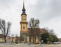 St.-Maria-Magdalena-Church
 -
 Marketplace
 -
 Akzisehaus
 -
 City Wall at the Akzisehaus
 -
 Seehotel Templin


Templin's city walls are small, but complete. There are 3 main gate towers and several modern entrances, where parts of the wall were torn down. The main Protestant church is the St.-Maria-Magdalenen-Kirche. The town has many eastern era Plattenbau houses (highrise apartments) and smaller neighborhoods.
The Lehmann-Garten, a botanical garden was recreated in 1988 in the park of the former Joachimsthalsches Gymnasium.
Hermann Göring from 1933 on had his country residence Carinhall erected in the forest south of Gollin. The building designed by Werner March was destroyed by Luftwaffe personnel in April 1945, just days before the Red Army reached the area.

North of Groß Dölln is an airfield built in the 1950s as a military airbase of the 16th Air Army of the Soviet Forces
Templin has recently built a spa and mainly relies on tourism. It is a popular destination for day-trippers from Berlin to enjoy the many glacial lakes and extended forests. There is no discothèque in Templin, the closest is in Milmersdorf. The town square with the old town hall building is surrounded by an active downtown. There are many shops and restaurants in the area and an outdoor market every week. Many neighbouring municipalities like Milmersdorf and several other villages rely on Templin for many services.
There is an old powder tower in the town wall known as the Pulverturm.
Twin towns
 Bad Lippspringe, Germany
 Połczyn-Zdrój, Poland
Notable people
- Friederike Krüger, (1789–1848), female Prussian soldier, died at Templin.
- Walter Ulbricht, politician (SED), (1893–1973), head of East German state 1960–1973, died at Groß Dölln.
- Herlind Kasner, (1928–2019), mother of Angela Merkel, born in Danzig (now Gdańsk, Poland), died at Templin.
- Angela Winkler, actress, born 1944 at Templin.
- Manfred Kokot, (born 1948), Olympic athlete.
- Angela Merkel, (born 1954), politician (CDU), German chancellor from 2005 to 2021 grew up from 1957 in Templin. Merkel was made an honorary citizen of Templin in 2019.[5]
- Christa Wiese (born 1967), athlete.
See also
References
- ^ 1.0 1.1 Landkreis Uckermark Wahl der Bürgermeisterin / des Bürgermeisters, accessed 4 July 2021.
- ^ "Bevölkerungsentwicklung und Bevölkerungsstandim Land Brandenburg Dezember 2022" (PDF). Amt für Statistik Berlin-Brandenburg (in German). June 2023.
{{cite web}}: CS1 maint: unrecognized language (link) - ^ "Templin | Landkreis Uckermark | Ergebnisse der Bürgermeisterwahlen | Wahlen". www.wahlen.brandenburg.de. Archived from the original on 2008-10-07.
- ^ Detailed data sources are to be found in the Wikimedia Commons.Population Projection Brandenburg at Wikimedia Commons
- ^ "Merkel made honorary citizen of Templin". DW.com. Feb 8, 2019. Retrieved 2023-08-02.
External links
![]() Media related to Templin at Wikimedia Commons
Media related to Templin at Wikimedia Commons
Towns and municipalities in Uckermark | ||
|---|---|---|
|  | |