Utopia Planitia
Utopia Planitia (Greek and Latin: "Utopia Land Plain") is a large plain[2] within Utopia, the largest recognized impact basin on Mars[a] and in the Solar System with an estimated diameter of 3,300 km (2,100 mi).[1] It is the Martian region where the Viking 2 lander touched down and began exploring on September 3, 1976, and the Zhurong rover touched down on May 14, 2021, as a part of the Tianwen-1 mission.[4][5] It is located at the antipode of Argyre Planitia, centered at 46°42′N 117°30′E / 46.7°N 117.5°E.[2] It is also in the Casius quadrangle, Amenthes quadrangle, and the Cebrenia quadrangle of Mars. The region is in the broader North Polar/Borealis Basin that covers most of the Northern Hemisphere of Mars.
 Map of the lower and mid-latitudes of Mars, with Utopia visible in dark blue in the top right | |
| Feature type | Impact basin |
|---|---|
| Location | Northeast of Isidis Planitia, northwest of Aetheria |
| Coordinates | 46°42′N 117°30′E / 46.7°N 117.5°E |
| Diameter | 3,300 km (2,100 mi).[1] |
.jpg)
The Utopia basin is estimated to have formed around 4.3-4.1 billion years ago.[6][7] The impactor was likely around 400–700 kilometres (250–430 mi) in diameter.[8][9][10] The basin was subsequently mostly filled in, resulting in a mascon (a strong positive gravity anomaly) detectable by orbiting satellites.[11][12]
Many rocks at Utopia Planitia appear perched, as if wind removed much of the soil at their bases.[13][14] A hard surface crust is formed by solutions of minerals moving up through soil and evaporating at the surface.[15] Some areas of the surface exhibit scalloped topography, a surface that looks like it was carved out by an ice cream scoop. This surface is thought to have formed by the degradation of an ice-rich permafrost.[16] Many features that look like pingos on the Earth are found in Utopia Planitia (~35–50° N; ~80–115° E).[17]
On November 22, 2016, NASA reported finding a large amount of underground ice in the Utopia Planitia region. The volume of water detected has been estimated to be equivalent to the volume of water in Lake Superior.[18][19][20]
Scalloped topography


Scalloped topography is common in the mid-latitudes of Mars, between 45° and 60° north and south. It is particularly prominent in the region of Utopia Planitia[21][22] in the northern hemisphere and in the region of Peneus and Amphitrites Patera[23][24] in the southern hemisphere. Such topography consists of shallow, rimless depressions with scalloped edges, commonly referred to as scalloped depressions or simply scallops. Scalloped depressions can be isolated or clustered and sometimes seem to coalesce. A typical scalloped depression displays a gentle equator-facing slope and a steeper pole-facing scarp. This topographic asymmetry is probably due to differences in insolation. Scalloped depressions are believed to form from the removal of subsurface material, possibly interstitial ice, by sublimation. This process may still be happening at present.[25]
-
![Scalloped ground, as seen by HiRISE under HiWish program. A study published in Icarus found that the landforms of scalloped topography can be made by the subsurface loss of water ice by sublimation under current Martian climate conditions. Their model predicts similar shapes when the ground has large amounts of pure ice, up to many tens of meters in depth.[26]](https://upload.wikimedia.org/wikipedia/commons/thumb/9/95/ESP_037461_2255scallopstop.jpg/190px-ESP_037461_2255scallopstop.jpg) Scalloped ground, as seen by HiRISE under HiWish program. A study published in Icarus found that the landforms of scalloped topography can be made by the subsurface loss of water ice by sublimation under current Martian climate conditions. Their model predicts similar shapes when the ground has large amounts of pure ice, up to many tens of meters in depth.[26]
Scalloped ground, as seen by HiRISE under HiWish program. A study published in Icarus found that the landforms of scalloped topography can be made by the subsurface loss of water ice by sublimation under current Martian climate conditions. Their model predicts similar shapes when the ground has large amounts of pure ice, up to many tens of meters in depth.[26] -
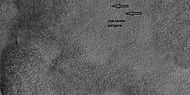
 Close up of scalloped ground, as seen by HiRISE under HiWish program. Surface is divided into polygons; these forms are common where ground freezes and thaws. Note: this is an enlargement of a previous image.
 -
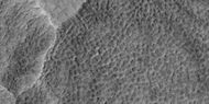
 Scalloped ground, as seen by HiRISE under HiWish program.
 -
 Close-up of scalloped ground, as seen by HiRISE under HiWish program. Surface is divided into polygons; these forms are common where ground freezes and thaws. Note: this is an enlargement of a previous image.
![Scalloped ground, as seen by HiRISE under HiWish program. A study published in Icarus found that the landforms of scalloped topography can be made by the subsurface loss of water ice by sublimation under current Martian climate conditions. Their model predicts similar shapes when the ground has large amounts of pure ice, up to many tens of meters in depth.[26]](/wiki/File:ESP_037461_2255scallopstop.jpg)


Pedestal craters
-
 Pedestal crater, as seen by HiRISE under HiWish program The ejecta is not symmetrical around crater because the asteroid came at a low angle out of the North East. The ejecta protected the underlying material from erosion; hence the crater looks elevated. The location is Casius quadrangle.
 -
 Close-up of East side (right side) of previous image of pedestal crater showing polygons on lobe. Since the margin of the crater has lobes and polygons, it is believed there is ice under the protective top. Picture taken with HiRISE under HiWish program. Note: this is an enlargement of the previous image.


Polygonal patterned ground
Polygonal, patterned ground is quite common in some regions of Mars.[27][28][29][30][31][32] It is commonly believed to be caused by the sublimation of ice from the ground. Sublimation is the direct change of solid ice to a gas. This is similar to what happens to dry ice on the Earth. Places on Mars that display polygonal ground may indicate where future colonists can find water ice. Patterned ground forms in a mantle layer, called latitude dependent mantle, that fell from the sky when the climate was different.[33][34][35][36]
-
 Low center polygons, shown with arrows, as seen by HiRISE under HiWish program Location is Casius quadrangle. Image was enlarged with HiView.
 -
 High center polygons, shown with arrows, as seen by HiRISE under HiWish program. Location is Casius quadrangle. Image enlarged with HiView.
 -
 Scalloped terrain labeled with both low center polygons and high center polygons, as seen by HiRISE under HiWish program. Location is Casius quadrangle. Image enlarged with HiView.
 -
 Low center polygons, as seen by HiRISE under HiWish program. Location is Casius quadrangle. Image enlarged with HiView.
 -
 High and low center polygons, as seen by HiRISE under HiWish program. Location is Casius quadrangle. Image enlarged with HiView.


Other features in Utopia Planitia
-
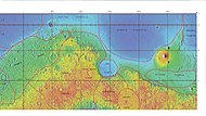 MOLA map showing boundaries for Utopia Planitia and other regions
 -
 Holes and hollows on crater floor in Utopia Planitia, as seen by HiRISE under HiWIsh program. These shapes may have resulted from ice leaving the ground.
 -
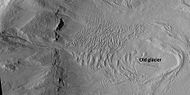 Glacier on a crater floor, as seen by HiRISE under HiWish program. The cracks in the glacier may be crevasses. There is also a gully system on the crater wall.
 -
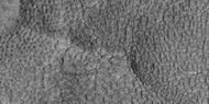
 Layered mesa, as seen by HiRISE under HiWish program
 -
 Context for next image of layers along Hrad Vallis, as seen by CTX. Photo labeled with layers, streamlined forms, and arrow indicating direction water flowed.
 -
 Layers exposed along Hrad Vallis, as seen by HiRISE under HiWish program


Gallery

In popular culture
In the Star Trek media franchise, Utopia Planitia—both on Mars' surface and a space station in areosynchronous orbit above it—is the site of a major United Federation of Planets shipyard, the Utopia Planitia Fleet Yards. Ships such as the USS Enterprise-D, USS Defiant, USS Voyager and USS Sao Paulo were built there.[37]
Interactive Mars map
<imagemap>
Image:Mars Map.JPG|thumb|center|620px|alt=Map of Mars|poly 377 357 423 380 407 405 369 389 Acheron Fossae poly 1316 75 1305 231 992 408 677 224 651 71 1069 169 Acidalia Planitia poly 564 320 555 402 464 416 449 348 489 317 Alba Mons poly 160 408 355 401 311 594 156 594 Amazonis Planitia poly 832 741 903 744 897 793 749 880 776 950 831 1052 829 1121 510 1126 653 854 Aonia Planitia poly 1186 320 1477 394 1040 732 960 635 952 525 Arabia Terra poly 155 70 578 72 580 258 156 429 377 238 284 224 308 283 158 408 Arcadia Planitia poly 875 1108 872 1128 956 1131 957 1041 906 1047 904 1084 Argentea Planum poly 871 871 935 887 926 942 884 967 837 918 Argyre Planitia poly 880 356 962 441 889 505 824 412 Chryse Planitia poly 515 777 575 751 671 792 684 835 580 854 Claritas Fossae poly 981 456 992 493 1076 412 1044 386 Cydonia Mensae poly 346 685 514 740 526 838 363 797 Daedalia Planum poly 1858 405 1968 412 1954 514 1860 505 Elysium Mons poly 1692 500 1945 509 2009 342 2092 588 2085 671 2007 689 Elysium Planitia poly 1848 617 1870 616 1882 638 1878 637 1848 639 Gale crater poly 1645 865 1675 858 1645 782 1600 789 Hadriaca Patera poly 1378 766 1418 783 1392 882 1356 874 Hellas Montes poly 1410 772 1515 769 1618 869 1493 943 1387 894 Hellas Planitia poly 1599 731 1610 599 1711 593 1750 717 Hesperia Planum poly 928 703 919 746 960 761 959 726 Holden crater poly 524 827 588 867 564 900 511 881 Icaria Planum poly 1587 447 1672 520 1619 575 1555 568 1538 500 Isidis Planitia poly 1531 475 1518 514 1547 516 1552 484 Jezero crater poly 1032 72 1030 87 1112 94 1124 166 1032 170 Lomonosov crater poly 153 569 280 579 293 650 156 651 Lucus Planum poly 356 411 400 451 357 486 329 465 Lycus Sulci poly 1243 254 1311 258 1309 310 1244 304 Lyot crater poly 738 489 823 493 792 597 704 573 Lunae Planum poly 1367 964 1552 989 1531 1099 1361 1078 Malea Planum poly 832 1047 920 1048 916 1124 839 1125 Maraldi crater poly 572 326 612 356 676 303 658 276 Mareotis Fossae poly 664 301 752 369 700 454 628 400 Mareotis Tempe poly 872 491 976 477 1054 609 953 635 Margaritifer Terra poly 1853 283 1857 333 1903 330 1899 281 Mie crater poly 309 233 346 235 344 265 303 267 Milankovič crater poly 1694 508 1665 562 1767 637 1798 575 Nepenthes Mensae poly 801 855 931 819 941 861 871 857 848 883 Nereidum Montes poly 1529 438 1446 412 1462 371 1525 404 Nilosyrtis Mensae poly 1197 672 994 834 978 1072 1276 1086 1365 785 Noachis Terra poly 471 410 547 418 532 488 479 470 Olympica Fossae poly 390 417 481 505 373 547 353 483 Olympus Mons poly 137 1061 139 1144 2102 1143 2103 1063 Planum Australe poly 1804 1124 1844 649 1663 650 1592 1129 Promethei Terra poly 1276 219 1262 253 1373 329 1383 302 Protonilus Mensae poly 151 729 314 737 323 852 156 885 Sirenum poly 1370 899 1432 952 1373 972 1339 933 Sisyphi Planum poly 585 631 784 692 697 823 574 807 Solis Planum poly 570 638 608 673 574 707 531 670 Syria Planum poly 602 232 645 243 595 314 561 306 Tantalus Fossae poly 727 306 790 260 840 392 731 497 693 567 Tempe Terra poly 1850 652 2080 675 2086 1128 1799 1125 Terra Cimmeria poly 1403 483 1547 596 1476 690 1350 749 1242 696 1214 642 Terra Sabaea poly 158 816 589 900 655 1124 171 1123 Terra Sirenum poly 547 484 611 530 488 714 413 656 Tharsis Montes poly 576 385 604 401 585 445 564 428 Tractus Catena poly 1583 607 1782 679 1762 800 1604 771 1531 738 Tyrrhena Terra poly 452 529 505 568 475 583 445 570 Ulysses Patera poly 608 432 641 439 633 467 605 456 Uranius Patera poly 1413 79 1421 296 1627 447 1820 471 1853 364 1832 277 1894 254 1918 311 1829 476 2079 214 2078 80 Utopia Planitia poly 589 582 907 651 865 716 572 655 Valles Marineris poly 139 51 142 132 2103 133 2104 53 Vastitas Borealis poly 824 475 915 593 889 632 789 604 Xanthe Terra
desc bottom-left</imagemap>
See also
Notes
References
- ^ 1.0 1.1 McGill, G. E. (1989-03-10). "Buried topography of Utopia, Mars: Persistence of a giant impact depression". Journal of Geophysical Research. 94: 2753–2759. Bibcode:1989JGR....94.2753M. doi:10.1029/JB094iB03p02753.
- ^ 2.0 2.1 "Utopia Planitia". Gazetteer of Planetary Nomenclature. USGS Astrogeology Science Center. Retrieved 2015-03-10.
- ^ "Utopia". Gazetteer of Planetary Nomenclature. USGS Astrogeology Science Center.
- ^ "China succeeds on country's first Mars landing attempt with Tianwen-1". nasaspaceglight.com. 15 May 2021. Retrieved May 15, 2021.
- ^ "China's first Mars rover Tianwen-1 launches this week. Here's what it will do". Space.com. 21 July 2020.
- ^ Robbins, Stuart J. (2022-12-01). "Inconsistency between the Ancient Mars and Moon Impact Records of Megameter-scale Craters". The Planetary Science Journal. 3 (12): 274. doi:10.3847/PSJ/aca282. ISSN 2632-3338.
- ^ Frey, Herbert (July 2008). "Ages of very large impact basins on Mars: Implications for the late heavy bombardment in the inner solar system". Geophysical Research Letters. 35 (13). doi:10.1029/2008GL033515. ISSN 0094-8276.
- ^ Arkani-Hamed, Jafar (April 2005). "Giant impact basins trace the ancient equator of Mars". Journal of Geophysical Research: Planets. 110 (E4). doi:10.1029/2004JE002343. ISSN 0148-0227.
- ^ Ruedas, Thomas; Breuer, Doris (May 2018). ""Isocrater" impacts: Conditions and mantle dynamical responses for different impactor types". Icarus. 306: 94–115. doi:10.1016/j.icarus.2018.02.005.
- ^ Branco, Hely C.; Miljkovic, Katarina; Plesa, Ana‐Catalina (April 2024). "New Numerically Derived Scaling Relationships for Impact Basins on Mars". Journal of Geophysical Research: Planets. 129 (4). doi:10.1029/2023JE008217. ISSN 2169-9097.
- ^ Klokočník, Jaroslav; Kletetschka, Gunther; Kostelecký, Jan; Bezděk, Aleš (December 2023). "Gravity aspects for Mars". Icarus. 406: 115729. doi:10.1016/j.icarus.2023.115729.
- ^ Searls, Mindi L.; Banerdt, W. Bruce; Phillips, Roger J. (August 2006). "Utopia and Hellas basins, Mars: Twins separated at birth". Journal of Geophysical Research: Planets. 111 (E8). doi:10.1029/2005JE002666. ISSN 0148-0227.
- ^ Mutch, T. et al. 1976. "The Surface of Mars: The View from the Viking 2 Lander". Science: 194. 1277–1283.
- ^ Hartmann, W. 2003. A Traveler's Guide to Mars. Workman Publishing. New York.
- ^ Arvidson, R. A. Binder, and K. Jones. 1976. "The Surface of Mars". Scientific American: 238. 76–89.
- ^ Sejourne, A. et al. 2012. Evidence of an eolian ice-rich and stratified permafrost in Utopia Planitia, Mars. Icarus. 60:248–254.
- ^ Soare, E., et al. 2019. Possible (closed system) pingo and ice-wedge/thermokarst complexes at the mid latitudes of Utopia Planitia, Mars. Icarus. doi:10.1016/j.icarus.2019.03.010
- ^ 18.0 18.1 Staff (November 22, 2016). "Scalloped Terrain Led to Finding of Buried Ice on Mars". NASA. Retrieved November 23, 2016.
- ^ 19.0 19.1 "Lake of frozen water the size of New Mexico found on Mars – NASA". The Register. November 22, 2016. Retrieved November 23, 2016.
- ^ 20.0 20.1 "Mars Ice Deposit Holds as Much Water as Lake Superior". NASA. November 22, 2016. Retrieved November 23, 2016.
- ^ Lefort, A.; Russell, P. S.; Thomas, N.; McEwen, A. S.; Dundas, C. M.; Kirk, R. L. (2009). "Observations of periglacial landforms in Utopia Planitia with the High Resolution Imaging Science Experiment (HiRISE)". Journal of Geophysical Research. 114 (E4): E04005. Bibcode:2009JGRE..114.4005L. doi:10.1029/2008JE003264.
- ^ Morgenstern, A; Hauber, E; Reiss, D; van Gasselt, S; Grosse, G; Schirrmeister, L (2007). "Deposition and degradation of a volatile-rich layer in Utopia Planitia, and implications for climate history on Mars" (PDF). Journal of Geophysical Research: Planets. 112 (E6): E06010. Bibcode:2007JGRE..112.6010M. doi:10.1029/2006JE002869.
- ^ Lefort, A.; Russell, P.S.; Thomas, N. (2010). "Scalloped terrains in the Peneus and Amphitrites Paterae region of Mars as observed by HiRISE". Icarus. 205 (1): 259. Bibcode:2010Icar..205..259L. doi:10.1016/j.icarus.2009.06.005.
- ^ Zanetti, M.; Hiesinger, H.; Reiss, D.; Hauber, E.; Neukum, G. (2009). "Scalloped Depression Development on Malea Planum and the Southern Wall of the Hellas Basin, Mars" (PDF). Lunar and Planetary Science. 40. p. 2178, abstract 2178. Bibcode:2009LPI....40.2178Z.
- ^ "HiRISE | Scallops and Polygons in the Utopia Planitia (PSP_007173_2245)". hirise.lpl.arizona.edu.
- ^ Dundas, C., S. Bryrne, A. McEwen. 2015. Modeling the development of martian sublimation thermokarst landforms. Icarus: 262, 154-169.
- ^ Kostama, V.-P., M. Kreslavsky, Head, J. 2006. Recent high-latitude icy mantle in the northern plains of Mars: Characteristics and ages of emplacement. Geophys. Res. Lett. 33 (L11201). doi:10.1029/2006GL025946.
- ^ Malin, M., Edgett, K. 2001. Mars Global Surveyor Mars Orbiter Camera: Interplanetary cruise through primary mission. J. Geophys. Res. 106 (E10), 23429–23540.
- ^ Milliken, R., et al. 2003. Viscous flow features on the surface of Mars: Observations from high-resolution Mars Orbiter Camera (MOC) images. J. Geophys. Res. 108 (E6). doi:10.1029/2002JE002005.
- ^ Mangold, N. 2005. High latitude patterned grounds on Mars: Classification, distribution and climatic control. Icarus 174, 336–359.
- ^ Kreslavsky, M., Head, J. 2000. Kilometer-scale roughness on Mars: Results from MOLA data analysis. J. Geophys. Res. 105 (E11), 26695–26712.
- ^ Seibert, N., J. Kargel. 2001. Small-scale martian polygonal terrain: Implications for liquid surface water. Geophys. Res. Lett. 28 (5), 899–902. S
- ^ Hecht, M. 2002. Metastability of water on Mars. Icarus 156, 373–386
- ^ Mustard, J., et al. 2001. Evidence for recent climate change on Mars from the identification of youthful near-surface ground ice. Nature 412 (6845), 411–414.
- ^ Kreslavsky, M.A., Head, J.W., 2002. High-latitude Recent Surface Mantle on Mars: New Results from MOLA and MOC. European Geophysical Society XXVII, Nice.
- ^ Head, J.W., Mustard, J.F., Kreslavsky, M.A., Milliken, R.E., Marchant, D.R., 2003. Recent ice ages on Mars. Nature 426 (6968), 797–802.
- ^ Okuda, Michael; Denise Okuda & Debbie Mirek (1999). The Star Trek Encyclopedia. Pocket Books. ISBN 0-671-53609-5.
External links
- Laser altimetry of the north pole of Mars Utopia Planitia located in upper right
- Google Mars scrollable map – centered on Utopia Planitia
- VL2 Site: Utopia Planitia (NASA)
- PIA00576: Martian Sunrise at Utopia Planitia (NASA Photojournal)
- PIA00530: Frost on Utopia Planitia (NASA Photojournal)
- PIA03796: Utopia Planitia (NASA Photojournal)
Lua error in mw.title.lua at line 346: bad argument #2 to 'title.new' (unrecognized namespace name 'Portal').